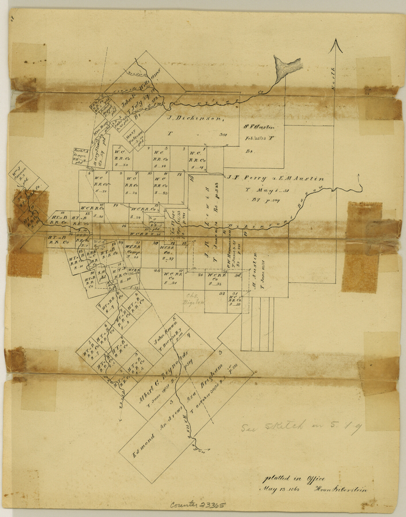
Galveston County Sketch File 8
[Office sketch of surveys on Dickinson Bayou]
-
Map/Doc
23365
-
Collection
General Map Collection
-
Object Dates
1862/5/13 (Creation Date)
-
People and Organizations
H. von Biberstein (Surveyor/Engineer)
-
Counties
Galveston Harris Brazoria
-
Subjects
Surveying Sketch File
-
Height x Width
11.2 x 8.8 inches
28.5 x 22.4 cm
-
Medium
paper, manuscript
-
Features
Seward's Creek
Bridge Creek
Clear Creek
Dickinson's Bayou
New Creek
Haus Bayou
Part of: General Map Collection
Souvenir - Opening and Dedication of the General Oil Company's New West Texas Oil Field

Souvenir - Opening and Dedication of the General Oil Company's New West Texas Oil Field
1920
Map/Doc 97263
Flight Mission No. DCL-7C, Frame 111, Kenedy County

Print $20.00
- Digital $50.00
Flight Mission No. DCL-7C, Frame 111, Kenedy County
1943
Size 18.5 x 22.3 inches
Map/Doc 86076
Flight Mission No. DQN-3K, Frame 7, Calhoun County

Print $20.00
- Digital $50.00
Flight Mission No. DQN-3K, Frame 7, Calhoun County
1953
Size 18.6 x 22.2 inches
Map/Doc 84339
Houston County Sketch File 25

Print $4.00
- Digital $50.00
Houston County Sketch File 25
Size 12.8 x 8.1 inches
Map/Doc 26798
Pecos County Rolled Sketch P

Print $20.00
- Digital $50.00
Pecos County Rolled Sketch P
1885
Size 39.0 x 46.1 inches
Map/Doc 9686
Maps of Gulf Intracoastal Waterway, Texas - Sabine River to the Rio Grande and connecting waterways including ship channels

Print $20.00
- Digital $50.00
Maps of Gulf Intracoastal Waterway, Texas - Sabine River to the Rio Grande and connecting waterways including ship channels
1966
Size 14.6 x 22.2 inches
Map/Doc 61966
Map of Harris District

Print $20.00
- Digital $50.00
Map of Harris District
1847
Size 25.4 x 34.4 inches
Map/Doc 1680
Milam County Sketch File 6

Print $4.00
- Digital $50.00
Milam County Sketch File 6
1902
Size 14.2 x 8.6 inches
Map/Doc 31634

Texas Gulf Coast Map from the Sabine River to the Rio Grande as subdivided for mineral development

Print $40.00
- Digital $50.00
Texas Gulf Coast Map from the Sabine River to the Rio Grande as subdivided for mineral development
1948
Size 44.0 x 69.2 inches
Map/Doc 2908
Flight Mission No. DAG-22K, Frame 77, Matagorda County

Print $20.00
- Digital $50.00
Flight Mission No. DAG-22K, Frame 77, Matagorda County
1953
Size 18.6 x 22.4 inches
Map/Doc 86464
Hall County Sketch File 32a

Print $56.00
- Digital $50.00
Hall County Sketch File 32a
1911
Size 14.4 x 8.6 inches
Map/Doc 24846
You may also like
[Report showing connections and corners made on ground in south part of Yoakum County and north part of Gaines County, Texas]

[Report showing connections and corners made on ground in south part of Yoakum County and north part of Gaines County, Texas]
1938
Size 8.1 x 10.9 inches
Map/Doc 93256
Brazoria County Sketch File 10

Print $40.00
- Digital $50.00
Brazoria County Sketch File 10
Size 16.4 x 12.7 inches
Map/Doc 14938
Flight Mission No. CGI-3N, Frame 103, Cameron County

Print $20.00
- Digital $50.00
Flight Mission No. CGI-3N, Frame 103, Cameron County
1954
Size 18.4 x 22.2 inches
Map/Doc 84583
Fort Bend County Sketch File 16 1/2

Print $16.00
- Digital $50.00
Fort Bend County Sketch File 16 1/2
Size 14.3 x 8.8 inches
Map/Doc 22927
Carte du Spits-Berg, et partie de la Côte de Galles hams-kes au nouveau Groenland

Print $20.00
- Digital $50.00
Carte du Spits-Berg, et partie de la Côte de Galles hams-kes au nouveau Groenland
1782
Size 13.8 x 19.8 inches
Map/Doc 97123
Map of the Panhandle Railway

Print $40.00
- Digital $50.00
Map of the Panhandle Railway
1888
Size 22.6 x 114.7 inches
Map/Doc 64461
Dimmit County Rolled Sketch 6
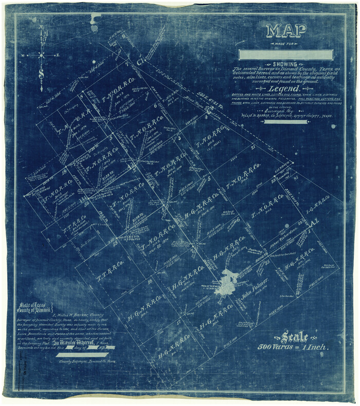
Print $20.00
- Digital $50.00
Dimmit County Rolled Sketch 6
Size 31.1 x 27.4 inches
Map/Doc 5716
Flight Mission No. DCL-6C, Frame 29, Kenedy County

Print $20.00
- Digital $50.00
Flight Mission No. DCL-6C, Frame 29, Kenedy County
1943
Size 18.6 x 22.4 inches
Map/Doc 85886
Wm. H. Bush Estate Resurveyed by W. D. Twichell May 1905

Print $40.00
- Digital $50.00
Wm. H. Bush Estate Resurveyed by W. D. Twichell May 1905
1905
Size 37.1 x 57.7 inches
Map/Doc 89788
Galveston County NRC Article 33.136 Location Key Sheet

Print $20.00
- Digital $50.00
Galveston County NRC Article 33.136 Location Key Sheet
1994
Size 27.0 x 21.8 inches
Map/Doc 77016
Map of Valley of Red River in Texas, Oklahoma, and Arkansas between Meridians 96 deg. 30 min. and 98 deg. West Longitude

Print $40.00
- Digital $50.00
Map of Valley of Red River in Texas, Oklahoma, and Arkansas between Meridians 96 deg. 30 min. and 98 deg. West Longitude
1920
Size 31.0 x 91.7 inches
Map/Doc 75252
Jefferson County Sketch File 55

Print $30.00
- Digital $50.00
Jefferson County Sketch File 55
1982
Size 11.1 x 8.5 inches
Map/Doc 28386