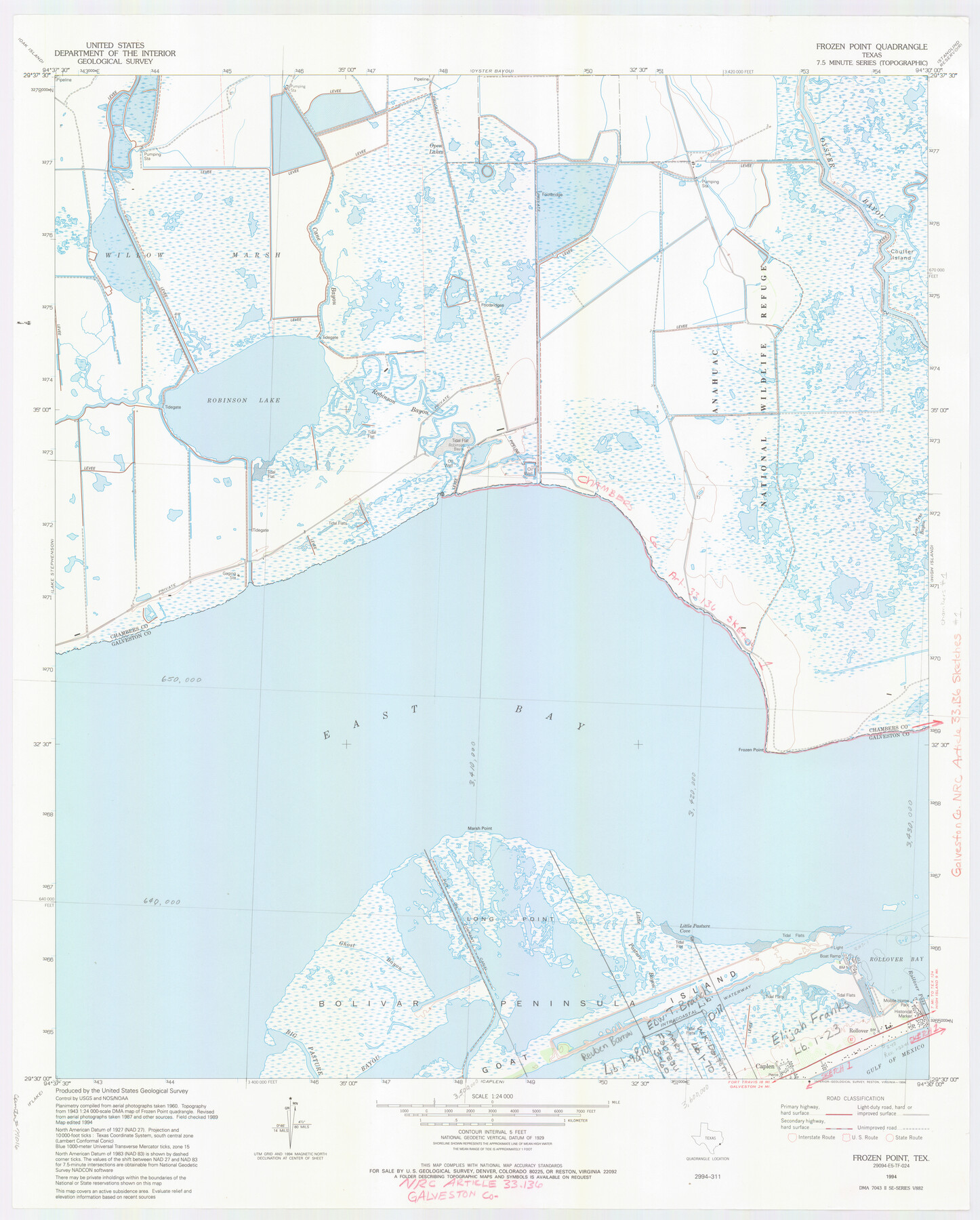
Galveston County NRC Article 33.136 Location Key Sheet
Smith Point Quadrangle
-
Map/Doc
77016
-
Collection
General Map Collection
-
Object Dates
1994 (Creation Date)
-
People and Organizations
U. S. Geological Survey (Publisher)
U. S. Geological Survey (Printer)
-
Counties
Galveston
-
Subjects
Surveying CBS
-
Height x Width
27.0 x 21.8 inches
68.6 x 55.2 cm
Part of: General Map Collection
Jefferson County Working Sketch 39

Print $20.00
- Digital $50.00
Jefferson County Working Sketch 39
1984
Size 39.3 x 28.2 inches
Map/Doc 66583
Hudspeth County Working Sketch 32a

Print $40.00
- Digital $50.00
Hudspeth County Working Sketch 32a
1975
Size 57.4 x 39.3 inches
Map/Doc 66317
Index sheet to accompany map of survey for connecting the inland waters along margin of the Gulf of Mexico from Donaldsonville in Louisiana to the Rio Grande River in Texas

Print $20.00
- Digital $50.00
Index sheet to accompany map of survey for connecting the inland waters along margin of the Gulf of Mexico from Donaldsonville in Louisiana to the Rio Grande River in Texas
1873
Size 18.2 x 28.1 inches
Map/Doc 72692
Township 11 South Range 13 West and 14 West, South Western District, Louisiana

Print $20.00
- Digital $50.00
Township 11 South Range 13 West and 14 West, South Western District, Louisiana
1838
Size 19.6 x 24.6 inches
Map/Doc 65854
Bell County Sketch File 31

Print $4.00
- Digital $50.00
Bell County Sketch File 31
1882
Size 8.0 x 8.9 inches
Map/Doc 14445
Culberson County Working Sketch 64

Print $20.00
- Digital $50.00
Culberson County Working Sketch 64
1975
Size 46.5 x 30.8 inches
Map/Doc 68518
[Texas & Pacific Railway through Callahan County]
![64233, [Texas & Pacific Railway through Callahan County], General Map Collection](https://historictexasmaps.com/wmedia_w700/maps/64233.tif.jpg)
Print $20.00
- Digital $50.00
[Texas & Pacific Railway through Callahan County]
1918
Size 20.5 x 9.4 inches
Map/Doc 64233
Frio County Rolled Sketch 7

Print $20.00
- Digital $50.00
Frio County Rolled Sketch 7
Size 21.0 x 17.4 inches
Map/Doc 5918
Erath County Working Sketch 47

Print $20.00
- Digital $50.00
Erath County Working Sketch 47
1984
Size 16.3 x 18.3 inches
Map/Doc 69128
Hemphill County Working Sketch 13

Print $20.00
- Digital $50.00
Hemphill County Working Sketch 13
1968
Size 26.2 x 24.0 inches
Map/Doc 66108
Hopkins County Sketch File 26

Print $4.00
- Digital $50.00
Hopkins County Sketch File 26
Size 8.4 x 6.1 inches
Map/Doc 26736
United States - Gulf Coast Texas - Southern part of Laguna Madre

Print $20.00
- Digital $50.00
United States - Gulf Coast Texas - Southern part of Laguna Madre
1933
Size 26.9 x 18.3 inches
Map/Doc 72952
You may also like
Cameron County Rolled Sketch 19

Print $2.00
- Digital $50.00
Cameron County Rolled Sketch 19
Size 7.1 x 5.7 inches
Map/Doc 5466
Red River, Water-Shed of Cypress Creek in Texas Drainage Area

Print $4.00
- Digital $50.00
Red River, Water-Shed of Cypress Creek in Texas Drainage Area
1925
Size 16.3 x 19.2 inches
Map/Doc 65057
Yoakum County Boundary File 1a

Print $20.00
- Digital $50.00
Yoakum County Boundary File 1a
Size 7.8 x 29.5 inches
Map/Doc 60196
Flight Mission No. BRA-16M, Frame 111, Jefferson County

Print $20.00
- Digital $50.00
Flight Mission No. BRA-16M, Frame 111, Jefferson County
1953
Size 18.5 x 22.2 inches
Map/Doc 85721
Surveys in Reeves and Culberson Counties, Texas and Pacific Railroad Company, Blocks 58, 59, 60, and 61

Print $20.00
- Digital $50.00
Surveys in Reeves and Culberson Counties, Texas and Pacific Railroad Company, Blocks 58, 59, 60, and 61
1937
Size 30.7 x 25.3 inches
Map/Doc 2250
San Patricio County Working Sketch 26

Print $20.00
- Digital $50.00
San Patricio County Working Sketch 26
1986
Size 29.0 x 34.4 inches
Map/Doc 63788
Map of the Southern part of Texas

Print $20.00
- Digital $50.00
Map of the Southern part of Texas
1831
Size 17.5 x 21.3 inches
Map/Doc 94442
Moore County Sketch File 14

Print $4.00
- Digital $50.00
Moore County Sketch File 14
Size 11.2 x 8.8 inches
Map/Doc 31961
[Upton County Sketch]
![5043, [Upton County Sketch], Maddox Collection](https://historictexasmaps.com/wmedia_w700/maps/5043-1.tif.jpg)
Print $40.00
- Digital $50.00
[Upton County Sketch]
Size 19.2 x 60.3 inches
Map/Doc 5043
Angelina County Working Sketch 58

Print $20.00
- Digital $50.00
Angelina County Working Sketch 58
2006
Size 24.1 x 36.0 inches
Map/Doc 83608
Williamson County Working Sketch 3

Print $20.00
- Digital $50.00
Williamson County Working Sketch 3
1915
Size 17.9 x 20.2 inches
Map/Doc 72563
[Galveston, Harrisburg & San Antonio Railroad from Cuero to Stockdale]
![64204, [Galveston, Harrisburg & San Antonio Railroad from Cuero to Stockdale], General Map Collection](https://historictexasmaps.com/wmedia_w700/maps/64204.tif.jpg)
Print $20.00
- Digital $50.00
[Galveston, Harrisburg & San Antonio Railroad from Cuero to Stockdale]
1907
Size 13.3 x 33.1 inches
Map/Doc 64204