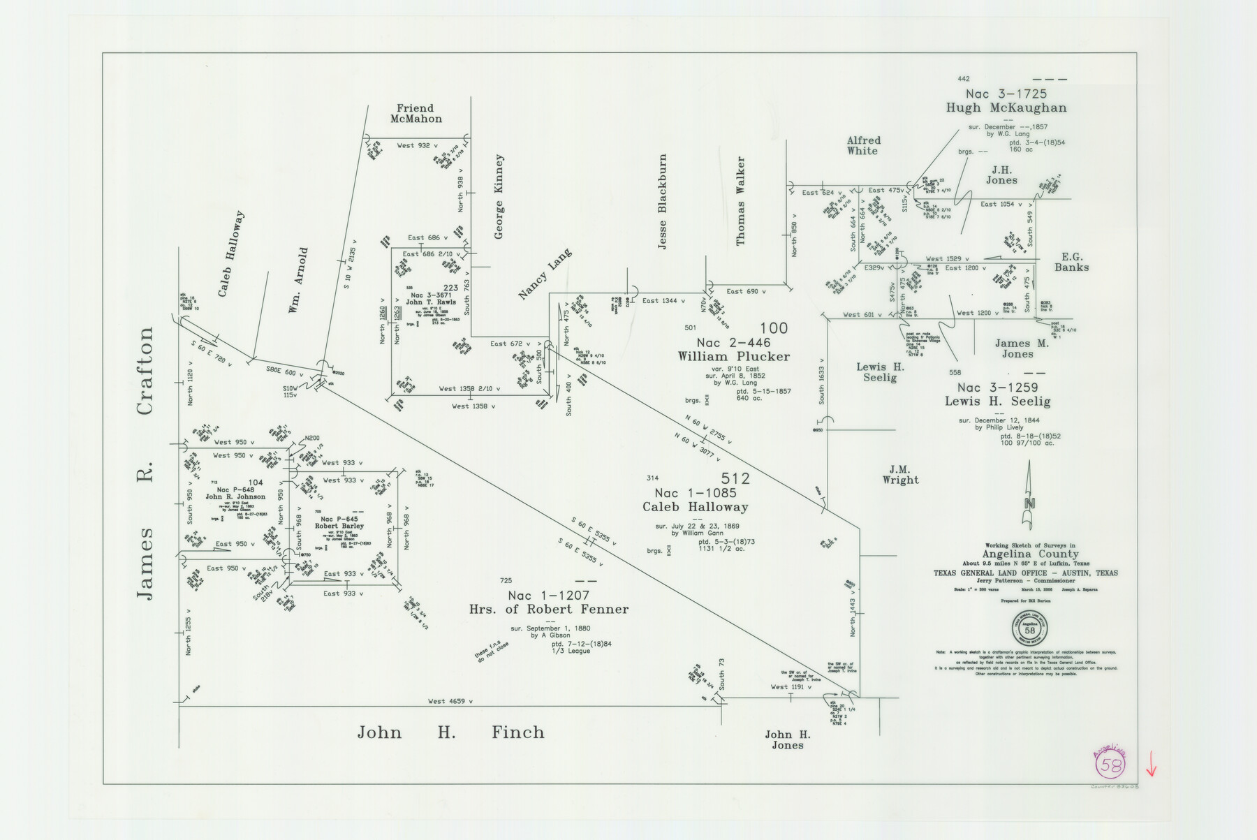
Angelina County Working Sketch 58
-
Map/Doc
83608
-
Collection
General Map Collection
-
Object Dates
3/15/2006 (Creation Date)
-
People and Organizations
Jerry E. Patterson (GLO Commissioner)
Joseph A. Esparza (Draftsman)
-
Counties
Angelina
-
Subjects
Surveying Working Sketch
-
Height x Width
24.1 x 36.0 inches
61.2 x 91.4 cm
-
Scale
1" = 300 varas
-
Comments
Surveys located about nine and one half miles North 65 degrees East of Lufkin, Texas.
Part of: General Map Collection
Taylor County Sketch File 9

Print $40.00
- Digital $50.00
Taylor County Sketch File 9
Size 14.6 x 15.8 inches
Map/Doc 37792

Zavala County Sketch File 39

Print $4.00
- Digital $50.00
Zavala County Sketch File 39
1884
Size 14.4 x 8.7 inches
Map/Doc 41404
Hunt County Working Sketch 8

Print $20.00
- Digital $50.00
Hunt County Working Sketch 8
1958
Size 24.5 x 24.4 inches
Map/Doc 66355
Maps of Gulf Intracoastal Waterway, Texas - Sabine River to the Rio Grande and connecting waterways including ship channels

Print $20.00
- Digital $50.00
Maps of Gulf Intracoastal Waterway, Texas - Sabine River to the Rio Grande and connecting waterways including ship channels
1966
Size 14.3 x 20.7 inches
Map/Doc 61998

Map of Port Bolivar

Print $20.00
- Digital $50.00
Map of Port Bolivar
1893
Size 24.9 x 18.5 inches
Map/Doc 2191
Hansford County

Print $20.00
- Digital $50.00
Hansford County
1889
Size 22.9 x 18.5 inches
Map/Doc 3624
Flight Mission No. CGI-4N, Frame 193, Cameron County

Print $20.00
- Digital $50.00
Flight Mission No. CGI-4N, Frame 193, Cameron County
1955
Size 18.6 x 22.3 inches
Map/Doc 84696
Map of Upton County

Print $20.00
- Digital $50.00
Map of Upton County
1889
Size 23.4 x 21.4 inches
Map/Doc 4104
Current Miscellaneous File 81

Print $14.00
- Digital $50.00
Current Miscellaneous File 81
1942
Size 14.2 x 8.9 inches
Map/Doc 74217

You may also like
Northeast Part Presidio County

Print $20.00
- Digital $50.00
Northeast Part Presidio County
1973
Size 39.6 x 31.3 inches
Map/Doc 77398
Galveston County Rolled Sketch WF

Print $20.00
- Digital $50.00
Galveston County Rolled Sketch WF
Size 25.2 x 34.1 inches
Map/Doc 5991
Crockett County Sketch File 39

Print $20.00
- Digital $50.00
Crockett County Sketch File 39
1889
Size 19.7 x 32.6 inches
Map/Doc 11221
Map of Parker County

Print $20.00
- Digital $50.00
Map of Parker County
1860
Size 24.1 x 19.0 inches
Map/Doc 3945
Sulphur River, Bassett Sheet

Print $20.00
- Digital $50.00
Sulphur River, Bassett Sheet
1939
Size 25.3 x 32.0 inches
Map/Doc 78320
Crockett County Sketch File 45

Print $14.00
- Digital $50.00
Crockett County Sketch File 45
Size 12.7 x 8.8 inches
Map/Doc 19772
Culberson County Sketch [showing PSL Blocks 109-111, 113-115 and University Block 46]
![90500, Culberson County Sketch [showing PSL Blocks 109-111, 113-115 and University Block 46], Twichell Survey Records](https://historictexasmaps.com/wmedia_w700/maps/90500-1.tif.jpg)
Print $20.00
- Digital $50.00
Culberson County Sketch [showing PSL Blocks 109-111, 113-115 and University Block 46]
Size 25.8 x 12.7 inches
Map/Doc 90500
Hemphill County Rolled Sketch 13

Print $20.00
- Digital $50.00
Hemphill County Rolled Sketch 13
1905
Size 20.7 x 28.9 inches
Map/Doc 6193
Flight Mission No. CRC-4R, Frame 185, Chambers County

Print $20.00
- Digital $50.00
Flight Mission No. CRC-4R, Frame 185, Chambers County
1956
Size 18.5 x 22.2 inches
Map/Doc 84936
Shelby County Sketch File 33

Print $8.00
- Digital $50.00
Shelby County Sketch File 33
1949
Size 11.5 x 9.0 inches
Map/Doc 36670
Flight Mission No. DQN-7K, Frame 36, Calhoun County

Print $20.00
- Digital $50.00
Flight Mission No. DQN-7K, Frame 36, Calhoun County
1953
Size 18.5 x 22.2 inches
Map/Doc 84474
Sterling County Sketch File 24

Print $6.00
- Digital $50.00
Sterling County Sketch File 24
1955
Size 11.1 x 8.5 inches
Map/Doc 37189