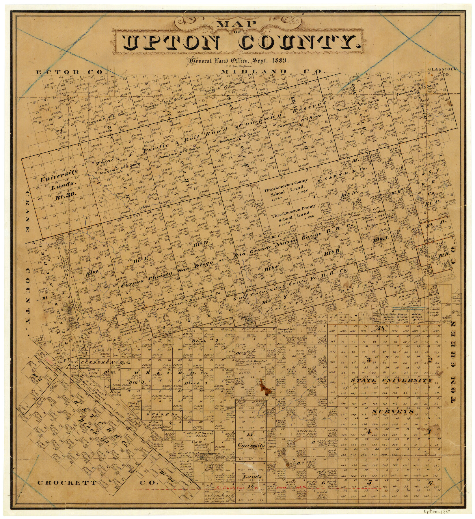
Map of Upton County
-
Map/Doc
4104
-
Collection
General Map Collection
-
Object Dates
9/1889 (Creation Date)
-
People and Organizations
Texas General Land Office (Publisher)
F.G. Blau (Compiler)
F.G. Blau (Draftsman)
-
Counties
Upton
-
Subjects
County
-
Height x Width
23.4 x 21.4 inches
59.4 x 54.4 cm
-
Features
Sugarloaf [sic] Mountains
Part of: General Map Collection
Right of Way & Track Map Houston & Brazos Valley Ry. operated by Houston & Brazos Valley Ry. Co., Hoskins Mound Branch

Print $40.00
- Digital $50.00
Right of Way & Track Map Houston & Brazos Valley Ry. operated by Houston & Brazos Valley Ry. Co., Hoskins Mound Branch
1924
Size 25.3 x 56.4 inches
Map/Doc 64611
Fisher County Sketch File 23

Print $12.00
- Digital $50.00
Fisher County Sketch File 23
1875
Size 10.8 x 8.2 inches
Map/Doc 22660
Sketch I: Showing the Progress of the Survey in Section No. 9 [Galveston Bay]
![97133, Sketch I: Showing the Progress of the Survey in Section No. 9 [Galveston Bay], General Map Collection](https://historictexasmaps.com/wmedia_w700/maps/97133.tif.jpg)
Print $20.00
- Digital $50.00
Sketch I: Showing the Progress of the Survey in Section No. 9 [Galveston Bay]
1852
Size 9.4 x 13.4 inches
Map/Doc 97133
Glasscock County Sketch File 2

Print $20.00
- Digital $50.00
Glasscock County Sketch File 2
1931
Size 35.1 x 16.2 inches
Map/Doc 11559
Frio County Sketch File 3

Print $4.00
- Digital $50.00
Frio County Sketch File 3
1854
Size 8.5 x 3.6 inches
Map/Doc 23109
Cherokee County Sketch File 14

Print $4.00
- Digital $50.00
Cherokee County Sketch File 14
1860
Size 8.0 x 5.9 inches
Map/Doc 18147
Hill County Sketch File 18

Print $26.00
- Digital $50.00
Hill County Sketch File 18
1852
Size 8.6 x 4.9 inches
Map/Doc 26486

McLennan County Working Sketch Graphic Index

Print $20.00
- Digital $50.00
McLennan County Working Sketch Graphic Index
1946
Size 41.8 x 44.8 inches
Map/Doc 76637
Howard County Sketch File 16

Print $40.00
- Digital $50.00
Howard County Sketch File 16
1947
Size 19.7 x 9.0 inches
Map/Doc 26878
East Part El Paso County

Print $20.00
- Digital $50.00
East Part El Paso County
1908
Size 47.6 x 40.9 inches
Map/Doc 66814
Mason County Working Sketch 4

Print $20.00
- Digital $50.00
Mason County Working Sketch 4
1932
Size 16.6 x 22.2 inches
Map/Doc 70840
You may also like
[Area Surrounding Lee County School Land]
![90887, [Area Surrounding Lee County School Land], Twichell Survey Records](https://historictexasmaps.com/wmedia_w700/maps/90887-1.tif.jpg)
Print $20.00
- Digital $50.00
[Area Surrounding Lee County School Land]
1907
Size 13.9 x 19.2 inches
Map/Doc 90887
El Paso County Rolled Sketch 47

Print $40.00
- Digital $50.00
El Paso County Rolled Sketch 47
1885
Size 41.3 x 90.4 inches
Map/Doc 8874
Frio County Working Sketch 8

Print $20.00
- Digital $50.00
Frio County Working Sketch 8
1948
Size 26.9 x 21.3 inches
Map/Doc 69282
[Panhandle Counties]
![92066, [Panhandle Counties], Twichell Survey Records](https://historictexasmaps.com/wmedia_w700/maps/92066-1.tif.jpg)
Print $2.00
- Digital $50.00
[Panhandle Counties]
1885
Size 12.6 x 8.9 inches
Map/Doc 92066
[Sketch of part of G. & M. Block 5]
![93072, [Sketch of part of G. & M. Block 5], Twichell Survey Records](https://historictexasmaps.com/wmedia_w700/maps/93072-1.tif.jpg)
Print $2.00
- Digital $50.00
[Sketch of part of G. & M. Block 5]
Size 3.9 x 6.6 inches
Map/Doc 93072
Map of Cass County

Print $20.00
- Digital $50.00
Map of Cass County
1847
Size 21.3 x 18.4 inches
Map/Doc 3368
Plats of the Resurvey of Clark's Texas-New Mexico Boundary by the U. S. Boundary Commission, 1911

Print $180.00
Plats of the Resurvey of Clark's Texas-New Mexico Boundary by the U. S. Boundary Commission, 1911
1911
Map/Doc 81690

Kimble County Sketch File 2

Print $2.00
- Digital $50.00
Kimble County Sketch File 2
Size 7.0 x 6.7 inches
Map/Doc 28909
Texas Gulf Coast Bay Index Map

Print $20.00
- Digital $50.00
Texas Gulf Coast Bay Index Map
Size 43.7 x 42.6 inches
Map/Doc 73599
[Southern Pacific Rail Road Co. Blocks 15 and 16 in Mitchell, Sterling and Coke Counties]
![91839, [Southern Pacific Rail Road Co. Blocks 15 and 16 in Mitchell, Sterling and Coke Counties], Twichell Survey Records](https://historictexasmaps.com/wmedia_w700/maps/91839-1.tif.jpg)
Print $20.00
- Digital $50.00
[Southern Pacific Rail Road Co. Blocks 15 and 16 in Mitchell, Sterling and Coke Counties]
Size 30.5 x 35.7 inches
Map/Doc 91839
Jones County Sketch File 9

Print $22.00
- Digital $50.00
Jones County Sketch File 9
Size 8.3 x 7.5 inches
Map/Doc 28495