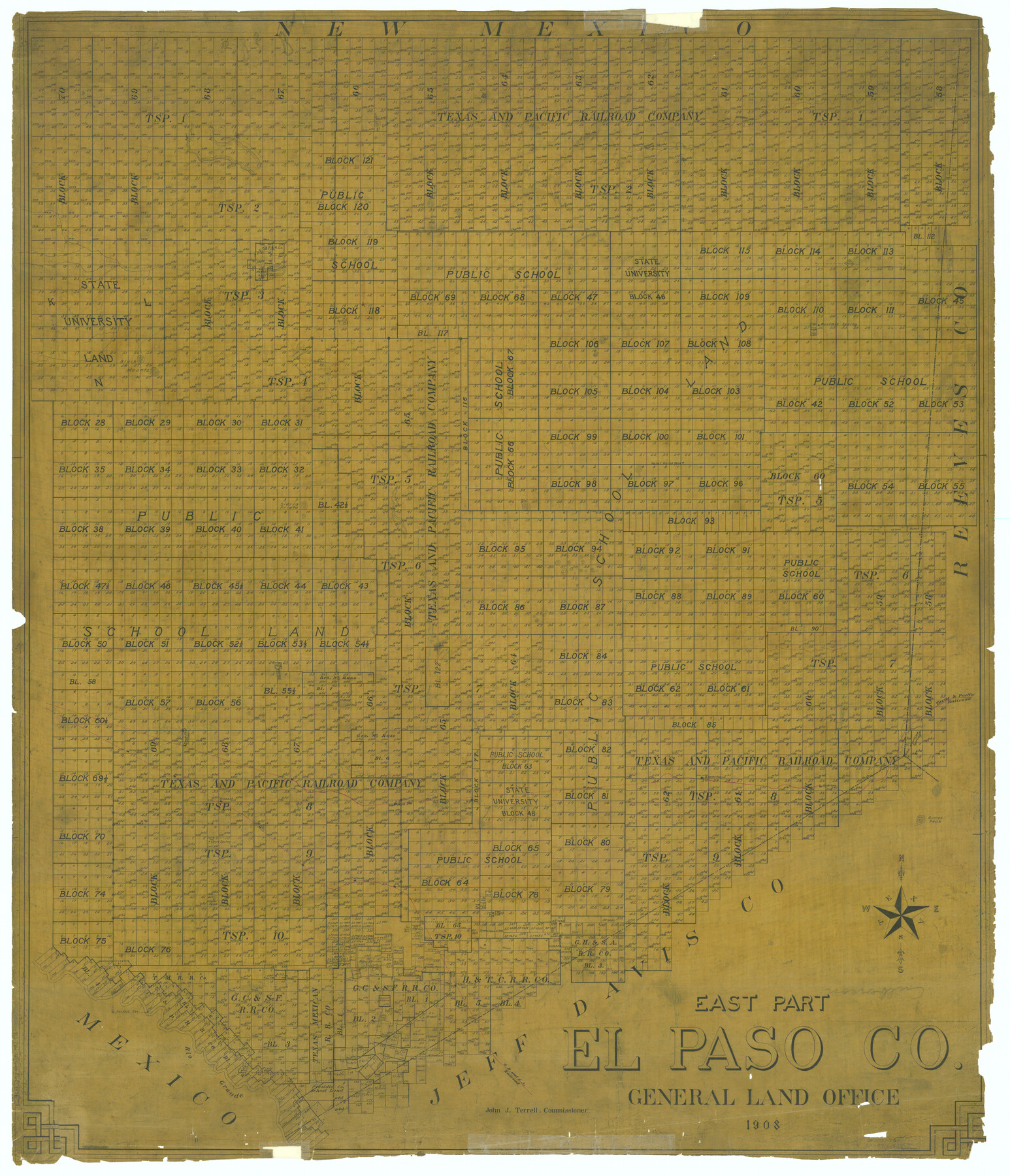
East Part El Paso County
-
Map/Doc
66814
-
Collection
General Map Collection
-
Object Dates
1908 (Creation Date)
-
People and Organizations
Texas General Land Office (Publisher)
Fred H. Simonds (Compiler)
John J. Terrell (GLO Commissioner)
Fred H. Simonds (Draftsman)
-
Counties
El Paso
-
Subjects
County
-
Height x Width
47.6 x 40.9 inches
120.9 x 103.9 cm
Part of: General Map Collection
Harris County Rolled Sketch 86

Print $40.00
- Digital $50.00
Harris County Rolled Sketch 86
Size 50.4 x 43.9 inches
Map/Doc 73581
[Sketch for Mineral Application 19560 - 19588 - San Bernard River]
![65579, [Sketch for Mineral Application 19560 - 19588 - San Bernard River], General Map Collection](https://historictexasmaps.com/wmedia_w700/maps/65579.tif.jpg)
Print $40.00
- Digital $50.00
[Sketch for Mineral Application 19560 - 19588 - San Bernard River]
1928
Size 33.0 x 98.6 inches
Map/Doc 65579
Brazos River, Fresno Sheet

Print $20.00
- Digital $50.00
Brazos River, Fresno Sheet
1938
Size 31.3 x 38.4 inches
Map/Doc 65289
Henderson County Working Sketch 11

Print $20.00
- Digital $50.00
Henderson County Working Sketch 11
1914
Size 20.7 x 22.5 inches
Map/Doc 66144
Webb County Working Sketch 71

Print $40.00
- Digital $50.00
Webb County Working Sketch 71
1973
Size 46.1 x 95.8 inches
Map/Doc 72438
Map of Leon County

Print $40.00
- Digital $50.00
Map of Leon County
1916
Size 49.3 x 42.5 inches
Map/Doc 66901
Grimes County Sketch File 3

Print $20.00
- Digital $50.00
Grimes County Sketch File 3
1871
Size 10.6 x 12.1 inches
Map/Doc 24626
[Cotton Belt, St. Louis Southwestern Railway of Texas, Alignment through Smith County]
![64387, [Cotton Belt, St. Louis Southwestern Railway of Texas, Alignment through Smith County], General Map Collection](https://historictexasmaps.com/wmedia_w700/maps/64387.tif.jpg)
Print $20.00
- Digital $50.00
[Cotton Belt, St. Louis Southwestern Railway of Texas, Alignment through Smith County]
1903
Size 21.7 x 29.5 inches
Map/Doc 64387
Uvalde County Working Sketch 6

Print $20.00
- Digital $50.00
Uvalde County Working Sketch 6
1940
Size 37.8 x 38.9 inches
Map/Doc 72076
Menard County Sketch File 29

Print $20.00
- Digital $50.00
Menard County Sketch File 29
1962
Size 21.0 x 41.1 inches
Map/Doc 10543
Hale County Sketch File 27

Print $20.00
- Digital $50.00
Hale County Sketch File 27
Size 12.1 x 28.5 inches
Map/Doc 11598
Flight Mission No. BRA-8M, Frame 82, Jefferson County

Print $20.00
- Digital $50.00
Flight Mission No. BRA-8M, Frame 82, Jefferson County
1953
Size 15.8 x 15.7 inches
Map/Doc 85602
You may also like
General Highway Map. Detail of Cities and Towns in Grimes County, Texas

Print $20.00
General Highway Map. Detail of Cities and Towns in Grimes County, Texas
1961
Size 18.2 x 24.8 inches
Map/Doc 79491
Hopkins County

Print $20.00
- Digital $50.00
Hopkins County
1942
Size 45.7 x 42.2 inches
Map/Doc 95533
General Highway Map, Hutchinson County, Texas

Print $20.00
General Highway Map, Hutchinson County, Texas
1961
Size 18.1 x 24.6 inches
Map/Doc 79529
La Salle County Sketch File 14

Print $4.00
- Digital $50.00
La Salle County Sketch File 14
Size 6.4 x 6.7 inches
Map/Doc 29483
Archer County

Print $20.00
- Digital $50.00
Archer County
1926
Size 43.8 x 38.7 inches
Map/Doc 77202

Mason County Working Sketch 23

Print $20.00
- Digital $50.00
Mason County Working Sketch 23
2004
Size 17.4 x 36.9 inches
Map/Doc 83577
[H. & O. B. Blocks 1, B9, 24, J]
![90345, [H. & O. B. Blocks 1, B9, 24, J], Twichell Survey Records](https://historictexasmaps.com/wmedia_w700/maps/90345-1.tif.jpg)
Print $20.00
- Digital $50.00
[H. & O. B. Blocks 1, B9, 24, J]
Size 25.2 x 23.6 inches
Map/Doc 90345
Map of Nacogdoches County

Print $40.00
- Digital $50.00
Map of Nacogdoches County
1839
Size 83.6 x 43.2 inches
Map/Doc 93370
1960 Texas Official Highway Travel Map

Digital $50.00
1960 Texas Official Highway Travel Map
Size 28.3 x 36.5 inches
Map/Doc 94330
Val Verde County Rolled Sketch 85

Print $20.00
- Digital $50.00
Val Verde County Rolled Sketch 85
2009
Size 25.4 x 38.0 inches
Map/Doc 89234
