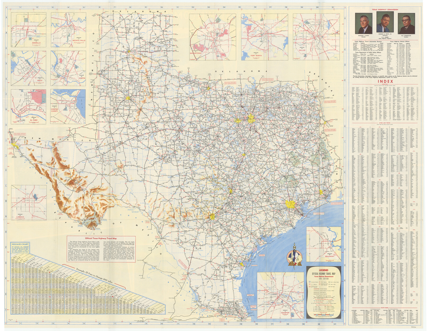
1960 Texas Official Highway Travel Map
[Verso - Map of Texas]
-
Map/Doc
94330
-
Collection
General Map Collection
-
Object Dates
1960 (Edition Date)
-
People and Organizations
Texas Highway Department (Publisher)
-
Subjects
State of Texas
-
Height x Width
28.3 x 36.5 inches
71.9 x 92.7 cm
-
Medium
paper, etching/engraving/lithograph
-
Comments
For photos of Texas scenes and attractions on recto see 94329. For reseach purposes only.
Related maps
1960 Texas Official Highway Travel Map

Digital $50.00
1960 Texas Official Highway Travel Map
Size 28.4 x 36.2 inches
Map/Doc 94329
Part of: General Map Collection
Galveston County NRC Article 33.136 Sketch 92

Print $62.00
Galveston County NRC Article 33.136 Sketch 92
2021
Map/Doc 97179
Trinity County Sketch File 22

Print $23.00
- Digital $50.00
Trinity County Sketch File 22
1877
Size 9.4 x 12.3 inches
Map/Doc 38550
Harris County Rolled Sketch 99

Print $20.00
- Digital $50.00
Harris County Rolled Sketch 99
1985
Size 16.2 x 20.2 inches
Map/Doc 6137
Duval County Working Sketch 37

Print $20.00
- Digital $50.00
Duval County Working Sketch 37
1958
Size 23.3 x 37.1 inches
Map/Doc 68761
[Right of Way & Track Map, The Texas & Pacific Ry. Co. Main Line]
![64668, [Right of Way & Track Map, The Texas & Pacific Ry. Co. Main Line], General Map Collection](https://historictexasmaps.com/wmedia_w700/maps/64668.tif.jpg)
Print $20.00
- Digital $50.00
[Right of Way & Track Map, The Texas & Pacific Ry. Co. Main Line]
Size 11.0 x 18.4 inches
Map/Doc 64668
Floyd County Sketch File 9a

Print $4.00
- Digital $50.00
Floyd County Sketch File 9a
1912
Size 14.5 x 8.9 inches
Map/Doc 22699
Mason County Sketch File 1

Print $6.00
- Digital $50.00
Mason County Sketch File 1
1857
Size 11.0 x 8.2 inches
Map/Doc 30677
Flight Mission No. CUG-1P, Frame 45, Kleberg County

Print $20.00
- Digital $50.00
Flight Mission No. CUG-1P, Frame 45, Kleberg County
1956
Size 18.5 x 22.2 inches
Map/Doc 86123
Nueces County Rolled Sketch 104A

Print $40.00
- Digital $50.00
Nueces County Rolled Sketch 104A
1975
Size 54.2 x 35.9 inches
Map/Doc 10293
Bosque County Working Sketch 8

Print $20.00
- Digital $50.00
Bosque County Working Sketch 8
1942
Size 23.1 x 33.4 inches
Map/Doc 67441
Calhoun County Working Sketch 8

Print $20.00
- Digital $50.00
Calhoun County Working Sketch 8
1943
Size 33.9 x 34.8 inches
Map/Doc 67824
Brewster County Working Sketch 8

Print $20.00
- Digital $50.00
Brewster County Working Sketch 8
1910
Size 42.3 x 30.3 inches
Map/Doc 67541
You may also like
[Blocks 341, G-5, G-12, TCRRCo.]
![60298, [Blocks 341, G-5, G-12, TCRRCo.], General Map Collection](https://historictexasmaps.com/wmedia_w700/maps/60298-1.tif.jpg)
Print $20.00
- Digital $50.00
[Blocks 341, G-5, G-12, TCRRCo.]
1954
Size 15.1 x 26.1 inches
Map/Doc 60298
Right of Way & Track Map, St. Louis, Brownsville & Mexico Ry. operated by St. Louis, Brownsville & Mexico Ry. Co.

Print $40.00
- Digital $50.00
Right of Way & Track Map, St. Louis, Brownsville & Mexico Ry. operated by St. Louis, Brownsville & Mexico Ry. Co.
1919
Size 25.7 x 57.6 inches
Map/Doc 64619
General Highway Map. Detail of Cities and Towns in Harris County, Texas

Print $20.00
General Highway Map. Detail of Cities and Towns in Harris County, Texas
1939
Size 18.2 x 24.9 inches
Map/Doc 79119
King County Sketch File 8

Print $46.00
- Digital $50.00
King County Sketch File 8
Size 8.8 x 8.9 inches
Map/Doc 29060
Bailey County, Texas

Print $20.00
- Digital $50.00
Bailey County, Texas
Size 30.1 x 41.8 inches
Map/Doc 92528
Schleicher County Rolled Sketch 6

Print $20.00
- Digital $50.00
Schleicher County Rolled Sketch 6
Size 28.1 x 21.1 inches
Map/Doc 7749
Flight Mission No. BRA-3M, Frame 199, Jefferson County

Print $20.00
- Digital $50.00
Flight Mission No. BRA-3M, Frame 199, Jefferson County
1953
Size 18.6 x 22.3 inches
Map/Doc 85414
[Surveys along the San Antonio Road and Cottonwood Creek]
![233, [Surveys along the San Antonio Road and Cottonwood Creek], General Map Collection](https://historictexasmaps.com/wmedia_w700/maps/233.tif.jpg)
Print $2.00
- Digital $50.00
[Surveys along the San Antonio Road and Cottonwood Creek]
1847
Size 9.1 x 8.3 inches
Map/Doc 233
Blanco County

Print $40.00
- Digital $50.00
Blanco County
1916
Size 48.7 x 35.7 inches
Map/Doc 66715
Reagan County Boundary File 1d

Print $36.00
- Digital $50.00
Reagan County Boundary File 1d
Size 9.2 x 8.3 inches
Map/Doc 58181
Matagorda County Working Sketch 28

Print $3.00
- Digital $50.00
Matagorda County Working Sketch 28
1980
Size 10.7 x 12.1 inches
Map/Doc 70886
Maverick County Working Sketch 15

Print $20.00
- Digital $50.00
Maverick County Working Sketch 15
1970
Size 34.6 x 24.7 inches
Map/Doc 70907