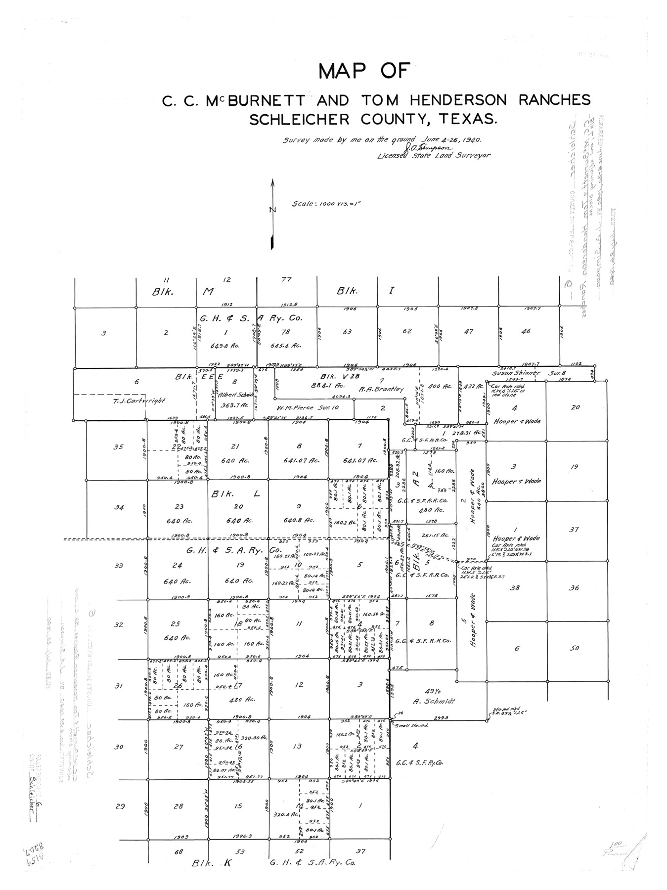
Schleicher County Rolled Sketch 6
Map of C.C. McBurnett and Tom Henderson Ranches
-
Map/Doc
7749
-
Collection
General Map Collection
-
Object Dates
1940/6/26 (Survey Date)
1940/7/26 (File Date)
-
People and Organizations
J.A. Simpson (Surveyor/Engineer)
-
Counties
Schleicher
-
Subjects
Surveying Rolled Sketch
-
Height x Width
28.1 x 21.1 inches
71.4 x 53.6 cm
-
Scale
1" = 1000 varas
Part of: General Map Collection
Liberty County Working Sketch 10

Print $40.00
- Digital $50.00
Liberty County Working Sketch 10
1909
Size 38.9 x 48.3 inches
Map/Doc 70469
Proceedings of The International (Water) Boundary Commission United States and Mexico Treaties of 1884 and 1889, Volume 2

Proceedings of The International (Water) Boundary Commission United States and Mexico Treaties of 1884 and 1889, Volume 2
Map/Doc 83145
Real County Working Sketch 4

Print $20.00
- Digital $50.00
Real County Working Sketch 4
1924
Size 17.1 x 15.5 inches
Map/Doc 71896
Johnson County Boundary File 51d

Print $6.00
- Digital $50.00
Johnson County Boundary File 51d
Size 7.9 x 17.8 inches
Map/Doc 55631
Pecos County Rolled Sketch 85

Print $20.00
- Digital $50.00
Pecos County Rolled Sketch 85
1931
Size 36.7 x 24.4 inches
Map/Doc 7243
Starr County Working Sketch 10

Print $20.00
- Digital $50.00
Starr County Working Sketch 10
1940
Size 38.1 x 32.4 inches
Map/Doc 63926
Crosby County Working Sketch 8

Print $20.00
- Digital $50.00
Crosby County Working Sketch 8
1938
Size 42.3 x 37.2 inches
Map/Doc 68442
Galveston County NRC Article 33.136 Sketch 30

Print $20.00
- Digital $50.00
Galveston County NRC Article 33.136 Sketch 30
2005
Size 12.1 x 15.5 inches
Map/Doc 82997
Burnet County Sketch File 23

Print $8.00
- Digital $50.00
Burnet County Sketch File 23
1853
Size 9.0 x 10.9 inches
Map/Doc 16718
[Sketch for Mineral Application 19560 - 19588 - San Bernard River]
![65662, [Sketch for Mineral Application 19560 - 19588 - San Bernard River], General Map Collection](https://historictexasmaps.com/wmedia_w700/maps/65662.tif.jpg)
Print $40.00
- Digital $50.00
[Sketch for Mineral Application 19560 - 19588 - San Bernard River]
Size 31.6 x 73.6 inches
Map/Doc 65662
Flight Mission No. BRA-7M, Frame 128, Jefferson County

Print $20.00
- Digital $50.00
Flight Mission No. BRA-7M, Frame 128, Jefferson County
1953
Size 18.8 x 22.5 inches
Map/Doc 85522

You may also like
Midland County Rolled Sketch 13

Print $20.00
- Digital $50.00
Midland County Rolled Sketch 13
Size 22.0 x 19.4 inches
Map/Doc 6768
Galveston County NRC Article 33.136 Sketch 79

Print $292.00
- Digital $50.00
Galveston County NRC Article 33.136 Sketch 79
2015
Size 22.0 x 34.0 inches
Map/Doc 94880
[Surveys in Milam District between the Bosque and Brazos Rivers]
![3, [Surveys in Milam District between the Bosque and Brazos Rivers], General Map Collection](https://historictexasmaps.com/wmedia_w700/maps/3.tif.jpg)
Print $20.00
- Digital $50.00
[Surveys in Milam District between the Bosque and Brazos Rivers]
1847
Size 15.8 x 12.2 inches
Map/Doc 3
Flight Mission No. DQO-7K, Frame 107, Galveston County

Print $20.00
- Digital $50.00
Flight Mission No. DQO-7K, Frame 107, Galveston County
1952
Size 18.6 x 22.6 inches
Map/Doc 85122
Ashburn's 1951 Austin City Map

Ashburn's 1951 Austin City Map
1951
Size 22.5 x 17.4 inches
Map/Doc 97142
Coleman County Sketch File 16

Print $4.00
- Digital $50.00
Coleman County Sketch File 16
1849
Size 9.6 x 8.3 inches
Map/Doc 18683
[Gulf Coast portion of] Map of the State of Texas
![72707, [Gulf Coast portion of] Map of the State of Texas, General Map Collection](https://historictexasmaps.com/wmedia_w700/maps/72707.tif.jpg)
Print $20.00
- Digital $50.00
[Gulf Coast portion of] Map of the State of Texas
1865
Size 27.4 x 18.1 inches
Map/Doc 72707
Menard County Sketch File 19

Print $4.00
- Digital $50.00
Menard County Sketch File 19
1905
Size 11.2 x 8.8 inches
Map/Doc 31546
Uvalde County Rolled Sketch 18

Print $20.00
- Digital $50.00
Uvalde County Rolled Sketch 18
Size 33.2 x 24.8 inches
Map/Doc 8102
Dickens County Sketch File 1a

Print $40.00
- Digital $50.00
Dickens County Sketch File 1a
1879
Size 16.8 x 13.8 inches
Map/Doc 20948
Denton County Rolled Sketch 8

Print $20.00
- Digital $50.00
Denton County Rolled Sketch 8
2007
Size 24.5 x 18.2 inches
Map/Doc 88762
[Part of Block GG and river sections 65-75]
![90469, [Part of Block GG and river sections 65-75], Twichell Survey Records](https://historictexasmaps.com/wmedia_w700/maps/90469-1.tif.jpg)
Print $20.00
- Digital $50.00
[Part of Block GG and river sections 65-75]
Size 21.9 x 20.2 inches
Map/Doc 90469