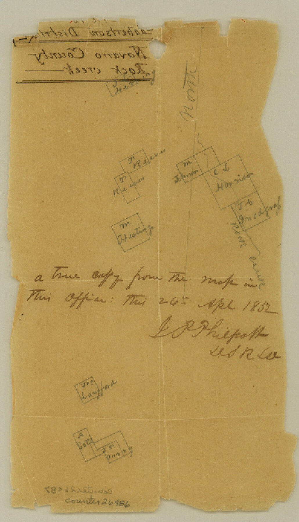
Hill County Sketch File 18
[Sketch on Rock Creek, east of Hillsboro]
-
Map/Doc
26486
-
Collection
General Map Collection
-
Object Dates
4/26/1852 (Creation Date)
-
People and Organizations
J.P. Philpott (Surveyor/Engineer)
-
Counties
Hill Johnson Ellis
-
Subjects
Surveying Sketch File
-
Height x Width
8.6 x 4.9 inches
21.8 x 12.5 cm
-
Medium
paper, manuscript
-
Features
Rock Creek
Trout Creek
Cotton Wood Branch
South Fork of Rock Creek
North Fork of Rock Creek
East Fork of Trout Creek
Part of: General Map Collection
Jackson County Boundary File 1a

Print $12.00
- Digital $50.00
Jackson County Boundary File 1a
Size 12.8 x 8.0 inches
Map/Doc 55431
Flight Mission No. CON-2R, Frame 173, Stonewall County

Print $20.00
- Digital $50.00
Flight Mission No. CON-2R, Frame 173, Stonewall County
1957
Size 18.3 x 22.1 inches
Map/Doc 86991
Jackson County Rolled Sketch 15

Print $40.00
- Digital $50.00
Jackson County Rolled Sketch 15
1945
Size 53.7 x 30.3 inches
Map/Doc 9261
Crane County Rolled Sketch 4

Print $40.00
- Digital $50.00
Crane County Rolled Sketch 4
Size 34.7 x 51.9 inches
Map/Doc 8337
Cochran County Boundary File 2

Print $59.00
- Digital $50.00
Cochran County Boundary File 2
Size 14.8 x 9.3 inches
Map/Doc 51466
Flight Mission No. DQO-8K, Frame 132, Galveston County

Print $20.00
- Digital $50.00
Flight Mission No. DQO-8K, Frame 132, Galveston County
1952
Size 18.8 x 22.6 inches
Map/Doc 85197
Flight Mission No. CGI-4N, Frame 176, Cameron County

Print $20.00
- Digital $50.00
Flight Mission No. CGI-4N, Frame 176, Cameron County
1955
Size 18.5 x 22.2 inches
Map/Doc 84679
Freestone County Rolled Sketch 7

Print $20.00
- Digital $50.00
Freestone County Rolled Sketch 7
1918
Size 41.4 x 36.9 inches
Map/Doc 8895
Young County Working Sketch 4

Print $20.00
- Digital $50.00
Young County Working Sketch 4
1919
Size 14.8 x 13.4 inches
Map/Doc 62027
Cameron County Rolled Sketch 19

Print $20.00
- Digital $50.00
Cameron County Rolled Sketch 19
1960
Size 27.0 x 20.5 inches
Map/Doc 5469
No. 3 Chart of Channel connecting Corpus Christi Bay with Aransas Bay, Texas

Print $20.00
- Digital $50.00
No. 3 Chart of Channel connecting Corpus Christi Bay with Aransas Bay, Texas
1878
Size 18.3 x 27.5 inches
Map/Doc 72784
[Surveys along the Trinity River, Bois d'Arc Creek and White Rock Lake]
![256, [Surveys along the Trinity River, Bois d'Arc Creek and White Rock Lake], General Map Collection](https://historictexasmaps.com/wmedia_w700/maps/256.tif.jpg)
Print $2.00
- Digital $50.00
[Surveys along the Trinity River, Bois d'Arc Creek and White Rock Lake]
Size 10.8 x 6.7 inches
Map/Doc 256
You may also like
[I. & G. N. Block 1]
![90343, [I. & G. N. Block 1], Twichell Survey Records](https://historictexasmaps.com/wmedia_w700/maps/90343-1.tif.jpg)
Print $20.00
- Digital $50.00
[I. & G. N. Block 1]
Size 13.1 x 18.1 inches
Map/Doc 90343
Falls County State Real Property Sketch 1

Print $40.00
- Digital $50.00
Falls County State Real Property Sketch 1
1999
Size 23.6 x 23.5 inches
Map/Doc 61669
Crockett County Sketch File H

Print $26.00
- Digital $50.00
Crockett County Sketch File H
1920
Size 14.4 x 9.0 inches
Map/Doc 19638
Sabine Pass and Lake

Print $20.00
- Digital $50.00
Sabine Pass and Lake
1971
Size 47.0 x 27.5 inches
Map/Doc 69825
Cass County Working Sketch 39

Print $20.00
- Digital $50.00
Cass County Working Sketch 39
1983
Size 26.3 x 34.6 inches
Map/Doc 67942
Stonewall County

Print $20.00
- Digital $50.00
Stonewall County
1897
Size 36.8 x 34.0 inches
Map/Doc 4057
Map of Austin Co.

Print $40.00
- Digital $50.00
Map of Austin Co.
1895
Size 49.3 x 43.6 inches
Map/Doc 4795
Colorado County Rolled Sketch 3

Print $20.00
- Digital $50.00
Colorado County Rolled Sketch 3
1943
Size 42.4 x 38.7 inches
Map/Doc 8641
Uvalde County Working Sketch 23

Print $20.00
- Digital $50.00
Uvalde County Working Sketch 23
1952
Size 32.0 x 26.6 inches
Map/Doc 72093
Harrison County Working Sketch 31

Print $40.00
- Digital $50.00
Harrison County Working Sketch 31
2006
Size 48.0 x 50.2 inches
Map/Doc 87148
Flight Mission No. BRE-2P, Frame 130, Nueces County

Print $20.00
- Digital $50.00
Flight Mission No. BRE-2P, Frame 130, Nueces County
1956
Size 18.6 x 22.3 inches
Map/Doc 86803
[Topographical Map showing part of Miller Day Ranch in Southwest Part of Coleman County]
![81515, [Topographical Map showing part of Miller Day Ranch in Southwest Part of Coleman County], General Map Collection](https://historictexasmaps.com/wmedia_w700/maps/81515.tif.jpg)
Print $3.00
- Digital $50.00
[Topographical Map showing part of Miller Day Ranch in Southwest Part of Coleman County]
Size 11.3 x 17.3 inches
Map/Doc 81515