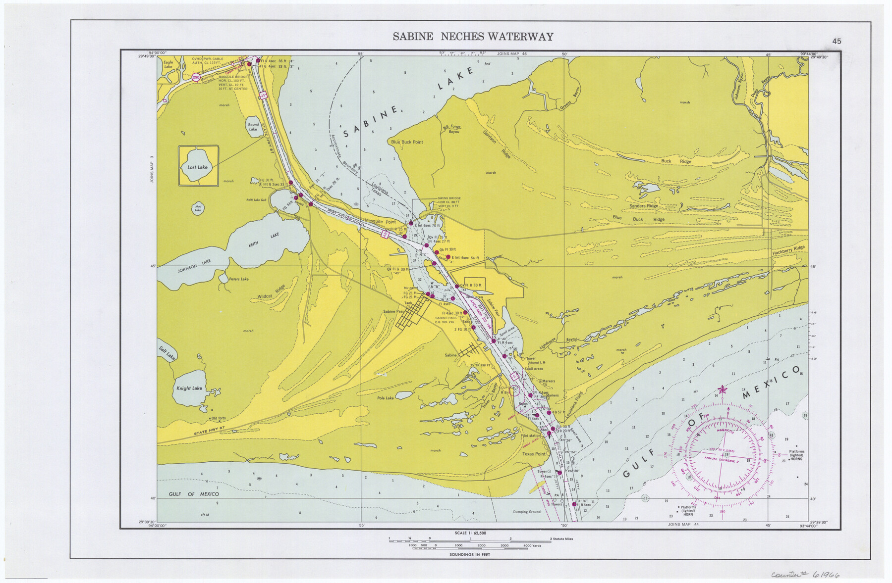
Maps of Gulf Intracoastal Waterway, Texas - Sabine River to the Rio Grande and connecting waterways including ship channels
-
Map/Doc
61966
-
Collection
General Map Collection
-
Object Dates
1966 (Creation Date)
-
Subjects
Intracoastal Waterways
-
Height x Width
14.6 x 22.2 inches
37.1 x 56.4 cm
Part of: General Map Collection
Real County Working Sketch 32

Print $20.00
- Digital $50.00
Real County Working Sketch 32
1948
Size 15.6 x 19.6 inches
Map/Doc 71924
Flight Mission No. DAH-17M, Frame 24, Orange County

Print $20.00
- Digital $50.00
Flight Mission No. DAH-17M, Frame 24, Orange County
1953
Size 18.5 x 22.4 inches
Map/Doc 86887
Flight Mission No. DQN-7K, Frame 3, Calhoun County

Print $20.00
- Digital $50.00
Flight Mission No. DQN-7K, Frame 3, Calhoun County
1953
Size 18.5 x 22.2 inches
Map/Doc 84454
Terrell County Working Sketch 70

Print $20.00
- Digital $50.00
Terrell County Working Sketch 70
1979
Size 39.0 x 36.5 inches
Map/Doc 69591
Jack County Working Sketch 17

Print $20.00
- Digital $50.00
Jack County Working Sketch 17
1982
Size 25.9 x 27.4 inches
Map/Doc 66443

Flight Mission No. BRA-16M, Frame 137, Jefferson County

Print $20.00
- Digital $50.00
Flight Mission No. BRA-16M, Frame 137, Jefferson County
1953
Size 18.7 x 22.3 inches
Map/Doc 85743
Cherokee County Working Sketch 17

Print $40.00
- Digital $50.00
Cherokee County Working Sketch 17
1958
Size 81.6 x 43.3 inches
Map/Doc 67972

No. 3 Chart of Channel connecting Corpus Christi Bay with Aransas Bay, Texas

Print $20.00
- Digital $50.00
No. 3 Chart of Channel connecting Corpus Christi Bay with Aransas Bay, Texas
1878
Size 18.3 x 27.9 inches
Map/Doc 72783
Gregg County Sketch File 1G

Print $2.00
- Digital $50.00
Gregg County Sketch File 1G
Size 6.2 x 7.0 inches
Map/Doc 24549
Rockwall County Boundary File 52a

Print $22.00
- Digital $50.00
Rockwall County Boundary File 52a
Size 12.9 x 8.3 inches
Map/Doc 58461
You may also like
Freestone County State of Texas

Print $20.00
- Digital $50.00
Freestone County State of Texas
1888
Size 27.2 x 21.6 inches
Map/Doc 3562
Culberson County Sketch File 43

Print $4.00
- Digital $50.00
Culberson County Sketch File 43
1931
Size 8.9 x 11.1 inches
Map/Doc 20329
Blucher's Directory Map of Corpus Christi and Road Map of Nueces County

Print $20.00
- Digital $50.00
Blucher's Directory Map of Corpus Christi and Road Map of Nueces County
1945
Size 22.7 x 34.4 inches
Map/Doc 94105
Flight Mission No. BRE-1P, Frame 97, Nueces County

Print $20.00
- Digital $50.00
Flight Mission No. BRE-1P, Frame 97, Nueces County
1956
Size 18.3 x 22.0 inches
Map/Doc 86668
General Highway Map, La Salle County, Texas

Print $20.00
General Highway Map, La Salle County, Texas
1961
Size 18.2 x 24.8 inches
Map/Doc 79565
Gaines County Rolled Sketch 15C

Print $20.00
- Digital $50.00
Gaines County Rolled Sketch 15C
Size 33.6 x 22.7 inches
Map/Doc 75929
Copano, St. Charles, Aransas and Red Fish Bays, in Aransas and Nueces Counties, showing Subdivision for Mineral Development

Print $40.00
- Digital $50.00
Copano, St. Charles, Aransas and Red Fish Bays, in Aransas and Nueces Counties, showing Subdivision for Mineral Development
1949
Size 55.9 x 40.0 inches
Map/Doc 1914
Culberson County Sketch File 33

Print $10.00
- Digital $50.00
Culberson County Sketch File 33
Size 11.2 x 8.8 inches
Map/Doc 20286
[G. B. & C. Blocks K3 and K4]
![90512, [G. B. & C. Blocks K3 and K4], Twichell Survey Records](https://historictexasmaps.com/wmedia_w700/maps/90512-1.tif.jpg)
Print $20.00
- Digital $50.00
[G. B. & C. Blocks K3 and K4]
Size 14.0 x 14.5 inches
Map/Doc 90512
Flight Mission No. CLL-1N, Frame 83, Willacy County

Print $20.00
- Digital $50.00
Flight Mission No. CLL-1N, Frame 83, Willacy County
1954
Size 18.3 x 22.0 inches
Map/Doc 87029
McMullen County Working Sketch 36

Print $20.00
- Digital $50.00
McMullen County Working Sketch 36
1963
Size 40.1 x 41.5 inches
Map/Doc 70737
Crockett County Sketch File 72

Print $14.00
- Digital $50.00
Crockett County Sketch File 72
Size 14.0 x 8.6 inches
Map/Doc 19862