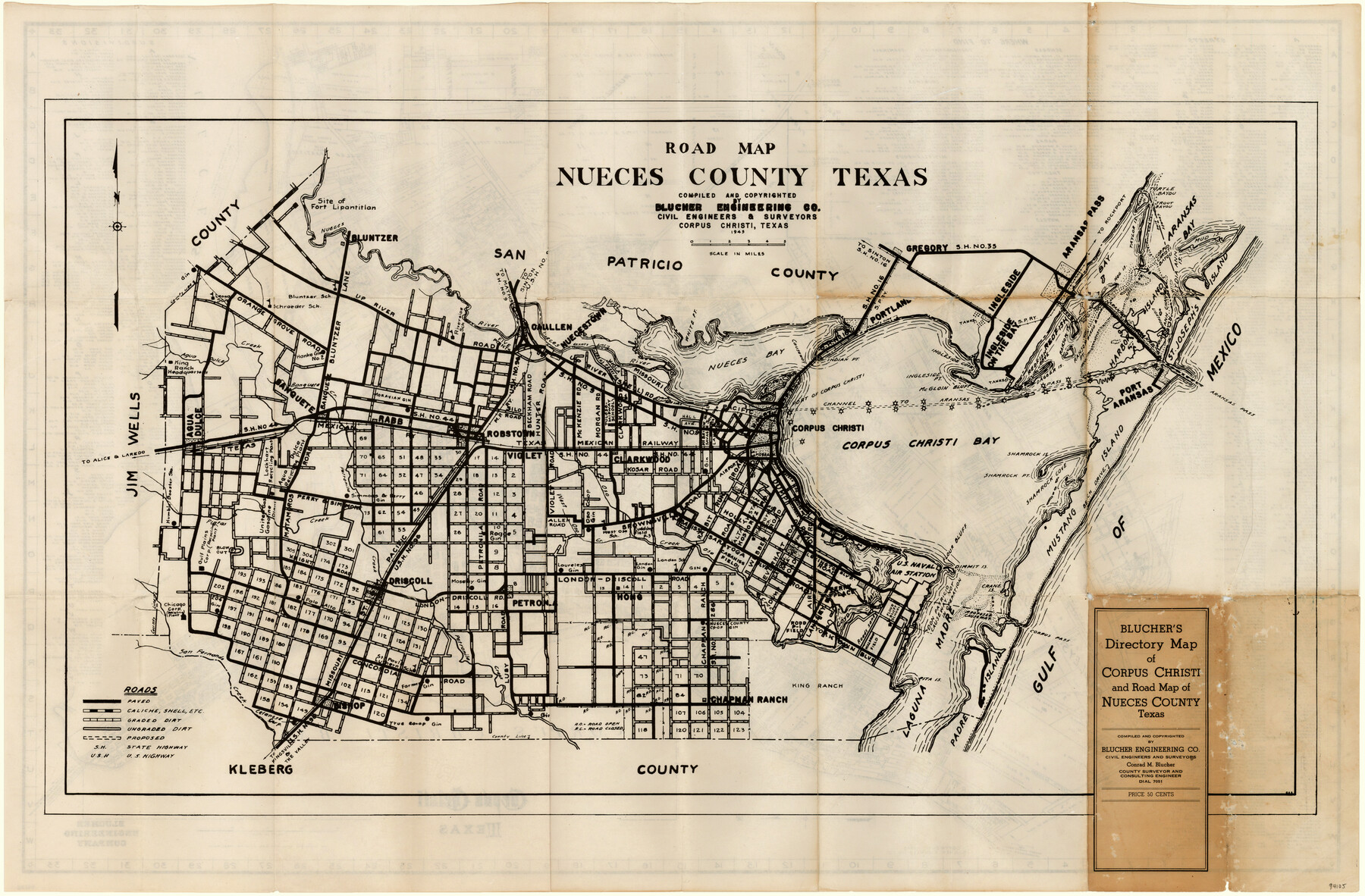
Blucher's Directory Map of Corpus Christi and Road Map of Nueces County
Road Map Nueces County, Texas
-
Map/Doc
94105
-
Collection
General Map Collection
-
Object Dates
1945 (Creation Date)
1945 (Copyright Date)
-
People and Organizations
Blucher Engineering Company (Publisher)
Conrad M. Blucher (Surveyor/Engineer)
-
Counties
Nueces
-
Subjects
County
-
Height x Width
22.7 x 34.4 inches
57.7 x 87.4 cm
-
Medium
paper, etching/engraving/lithograph
-
Comments
See 94106 for a map of Corpus Christi on verso.
-
Features
[Road] to Alice
Flour Bluff
U.S. Naval Air Station
London School
Brownsville Road
West Oso School
Oso Creek
West Oso Creek
Petranila Creek
Pintas Creek
[Road] to Laredo
Dimmit Island
King Ranch Headquarters
Agua Dulce Creek
Banquete
Banquete Creek
Robstown
Rabb
State Highway No. 44
MP
McGloin Bluff
Driscoll Road
Pita Island
King Ranch
Padre Island
Laguna Madre
Bichop
Kleberg
[Road] to the Valley
[Road] to Kingsville
[Road] to Kingsville & the Valley
San Fernando Creek
Ingleside Point
London Road
London-Driscoll Road
Flour Bluff School
Crane Island
Corpus Pass
Mustang Island
Shamrock Point
Shamrock Cove
Shamrock Island
Calallen
Southern Pacific Railroad Company
Gregory
Ingleside Cove
[Road] to Sinton
Portland
State Highway No. 16
Indian Point
Nueces Bay
White Point
Nuecestown
[Road] to Rockport
U.S. Highway No. 96
[Road] to Mathis
State Highway No. 9
Riverside School
Leona School
Schroeder School
Bluntzer School
Bluntzer
Nueces River
Lydia Ann Channel
Ingleside on the Bay
Ingleside
Lighthouse
Redfish Cove
Dagger Island
Harbor Island
Ransom Point
Ransom Island
St. Joseph's Island
Fort Lipantitlan
Lydia Ann Island
Mud Island
Aransas Bay
Corpus Christi Bayou
Trout Bayou
Turtle Bayou
Hog Island
Tally Island
Taylor Island
Related maps
Blucher's Directory Map of Corpus Christi and Road Map of Nueces County

Print $20.00
- Digital $50.00
Blucher's Directory Map of Corpus Christi and Road Map of Nueces County
1945
Size 22.6 x 34.3 inches
Map/Doc 94106
Part of: General Map Collection
Donley County Sketch File 30

Print $24.00
- Digital $50.00
Donley County Sketch File 30
1906
Size 11.3 x 8.7 inches
Map/Doc 21270
Wilson County Working Sketch Graphic Index

Print $20.00
- Digital $50.00
Wilson County Working Sketch Graphic Index
1921
Size 39.5 x 47.7 inches
Map/Doc 76743
Map of the Fort Worth & Denver City Ry., Dallam County, Texas

Print $40.00
- Digital $50.00
Map of the Fort Worth & Denver City Ry., Dallam County, Texas
1887
Size 21.3 x 111.8 inches
Map/Doc 64352
Brewster County Rolled Sketch 122

Print $20.00
- Digital $50.00
Brewster County Rolled Sketch 122
1974
Size 32.0 x 25.5 inches
Map/Doc 5297
United States - Gulf Coast - Galveston to Rio Grande

Print $20.00
- Digital $50.00
United States - Gulf Coast - Galveston to Rio Grande
1919
Size 27.1 x 18.3 inches
Map/Doc 72749
Lampasas County Sketch File 9a

Print $4.00
- Digital $50.00
Lampasas County Sketch File 9a
1872
Size 12.8 x 8.0 inches
Map/Doc 29410
[Surveys along the Colorado River]
![61, [Surveys along the Colorado River], General Map Collection](https://historictexasmaps.com/wmedia_w700/maps/61.tif.jpg)
Print $20.00
- Digital $50.00
[Surveys along the Colorado River]
1841
Size 14.4 x 16.1 inches
Map/Doc 61
Flight Mission No. DIX-5P, Frame 106, Aransas County

Print $20.00
- Digital $50.00
Flight Mission No. DIX-5P, Frame 106, Aransas County
1956
Size 17.8 x 18.0 inches
Map/Doc 83784
Tyler County Working Sketch Graphic Index

Print $20.00
- Digital $50.00
Tyler County Working Sketch Graphic Index
1944
Size 47.4 x 39.6 inches
Map/Doc 76719
Frio County Sketch File 23

Print $6.00
- Digital $50.00
Frio County Sketch File 23
2013
Size 11.0 x 8.5 inches
Map/Doc 93418
San Augustine County Sketch File 14

Print $22.00
San Augustine County Sketch File 14
1888
Size 13.2 x 12.6 inches
Map/Doc 35662
Cochran County Boundary File 1

Print $108.00
- Digital $50.00
Cochran County Boundary File 1
Size 15.4 x 8.7 inches
Map/Doc 51445
You may also like
Edwards County Working Sketch 48

Print $20.00
- Digital $50.00
Edwards County Working Sketch 48
1950
Size 46.3 x 38.2 inches
Map/Doc 68924

Map of Mexico, Guatimala and the West Indies (Inset: Map of the Country between the cities of Mexico and Vera Cruz)

Print $20.00
- Digital $50.00
Map of Mexico, Guatimala and the West Indies (Inset: Map of the Country between the cities of Mexico and Vera Cruz)
1849
Size 9.5 x 11.8 inches
Map/Doc 93500
Trinity River, East Fork of Trinity River Levee Improvement Districts/Widths of Floodways as Established by Approved Plans

Print $4.00
- Digital $50.00
Trinity River, East Fork of Trinity River Levee Improvement Districts/Widths of Floodways as Established by Approved Plans
1919
Size 28.4 x 18.5 inches
Map/Doc 65248
Map of Coleman County

Print $40.00
- Digital $50.00
Map of Coleman County
1897
Size 49.9 x 34.2 inches
Map/Doc 4741
Hidalgo County Sketch File 2

Print $14.00
- Digital $50.00
Hidalgo County Sketch File 2
1877
Size 10.1 x 8.1 inches
Map/Doc 26394
Bee County Sketch File 33

Print $56.00
- Digital $50.00
Bee County Sketch File 33
Size 11.3 x 8.9 inches
Map/Doc 14349

Moore County Rolled Sketch 16A

Print $20.00
- Digital $50.00
Moore County Rolled Sketch 16A
1982
Size 21.1 x 33.4 inches
Map/Doc 6834
Coast Chart No. 210 - Aransas Pass and Corpus Christi Bay with the coast to latitude 27° 12', Texas

Print $20.00
- Digital $50.00
Coast Chart No. 210 - Aransas Pass and Corpus Christi Bay with the coast to latitude 27° 12', Texas
1907
Size 18.4 x 24.1 inches
Map/Doc 73453
Red River County Working Sketch Graphic Index, Sheet 2 (Sketches 49 to Most Recent)

Print $20.00
- Digital $50.00
Red River County Working Sketch Graphic Index, Sheet 2 (Sketches 49 to Most Recent)
1934
Size 46.4 x 39.1 inches
Map/Doc 76681
Hudspeth County Sketch File 21a

Print $10.00
- Digital $50.00
Hudspeth County Sketch File 21a
Size 10.6 x 8.4 inches
Map/Doc 26969