Aransas County NRC Article 33.136 Sketch 8
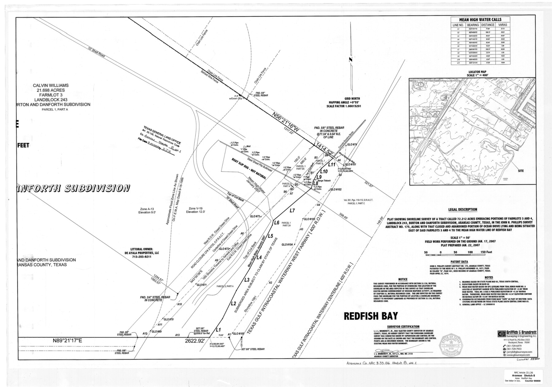
Plat Showing Mean High Water Line Between Called 72.212 Acres Embracing Portions of Farmlots 3 and 4, Landblock 243, Burton & Danforth Subdivision and State Submerged Area Tract 222, Redfish Bay
-
Map/Doc
88800
-
Collection
General Map Collection
-
Object Dates
2007/1/22 (Creation Date)
2008/3/20 (File Date)
-
People and Organizations
Griffith & Brundrett (Publisher)
Griffith & Brundrett (Printer)
Jerald L. Brundrett Jr. (Surveyor/Engineer)
-
Counties
Aransas
-
Subjects
Surveying CBS
-
Height x Width
24.0 x 36.0 inches
61.0 x 91.4 cm
-
Medium
multi-page, multi-format
-
Comments
Survey located about five and one half miles South 28 degrees West of Rockport, Texas.
Part of: General Map Collection
Map of the Texas & Pacific Ry. Reserve West of the Pecos River

Print $20.00
- Digital $50.00
Map of the Texas & Pacific Ry. Reserve West of the Pecos River
1879
Size 41.2 x 29.9 inches
Map/Doc 65334

Howard County Rolled Sketch 10

Print $20.00
- Digital $50.00
Howard County Rolled Sketch 10
Size 19.5 x 21.3 inches
Map/Doc 6240
Taylor County Sketch File 23

Print $19.00
- Digital $50.00
Taylor County Sketch File 23
2005
Size 11.0 x 8.5 inches
Map/Doc 87114
Cochran County Working Sketch 1

Print $20.00
- Digital $50.00
Cochran County Working Sketch 1
1940
Size 21.1 x 35.9 inches
Map/Doc 68012
Montgomery County Sketch File 28

Print $22.00
- Digital $50.00
Montgomery County Sketch File 28
Size 14.1 x 8.7 inches
Map/Doc 31873
Erath County Rolled Sketch 5

Print $20.00
- Digital $50.00
Erath County Rolled Sketch 5
Size 31.2 x 39.5 inches
Map/Doc 8883
Smith County Rolled Sketch 6E1

Print $20.00
- Digital $50.00
Smith County Rolled Sketch 6E1
1966
Size 27.4 x 22.7 inches
Map/Doc 10612
Wichita County Working Sketch 24

Print $20.00
- Digital $50.00
Wichita County Working Sketch 24
1971
Size 21.2 x 16.2 inches
Map/Doc 72534
[Surveys above the San Antonio Road]
![69758, [Surveys above the San Antonio Road], General Map Collection](https://historictexasmaps.com/wmedia_w700/maps/69758.tif.jpg)
Print $2.00
- Digital $50.00
[Surveys above the San Antonio Road]
1846
Size 8.5 x 7.6 inches
Map/Doc 69758
Hunt County Working Sketch 11

Print $20.00
- Digital $50.00
Hunt County Working Sketch 11
2002
Size 32.1 x 29.6 inches
Map/Doc 66358
Flight Mission No. DCL-6C, Frame 23, Kenedy County

Print $20.00
- Digital $50.00
Flight Mission No. DCL-6C, Frame 23, Kenedy County
1943
Size 18.7 x 22.3 inches
Map/Doc 85880
You may also like
Houston County Sketch File 42

Print $6.00
- Digital $50.00
Houston County Sketch File 42
1846
Size 11.5 x 9.5 inches
Map/Doc 26830
Flight Mission No. CRC-2R, Frame 58, Chambers County

Print $20.00
- Digital $50.00
Flight Mission No. CRC-2R, Frame 58, Chambers County
1956
Size 18.8 x 22.6 inches
Map/Doc 84729
Controlled Mosaic by Jack Amman Photogrammetric Engineers, Inc - Sheet 23

Print $20.00
- Digital $50.00
Controlled Mosaic by Jack Amman Photogrammetric Engineers, Inc - Sheet 23
1954
Size 20.0 x 24.0 inches
Map/Doc 83472
Duval County Working Sketch 45

Print $20.00
- Digital $50.00
Duval County Working Sketch 45
1979
Size 29.7 x 30.8 inches
Map/Doc 68769
General Highway Map, Harris County, Texas

Print $20.00
General Highway Map, Harris County, Texas
1961
Size 24.9 x 18.0 inches
Map/Doc 79502

Brazoria County Sketch File 36

Print $40.00
- Digital $50.00
Brazoria County Sketch File 36
1933
Size 34.6 x 45.6 inches
Map/Doc 10325
El Paso County Rolled Sketch 58

Print $20.00
- Digital $50.00
El Paso County Rolled Sketch 58
1987
Size 18.6 x 24.6 inches
Map/Doc 5851
Angelina County Working Sketch 27

Print $40.00
- Digital $50.00
Angelina County Working Sketch 27
1954
Size 31.0 x 56.6 inches
Map/Doc 67109
Harris County Sketch File F

Print $4.00
- Digital $50.00
Harris County Sketch File F
1860
Size 10.1 x 5.1 inches
Map/Doc 25317
Jackson County Sketch File 8

Print $20.00
- Digital $50.00
Jackson County Sketch File 8
Size 30.5 x 35.7 inches
Map/Doc 10503
Traveller's Map of the State of Texas

Print $20.00
- Digital $50.00
Traveller's Map of the State of Texas
1867
Size 40.7 x 38.7 inches
Map/Doc 2130