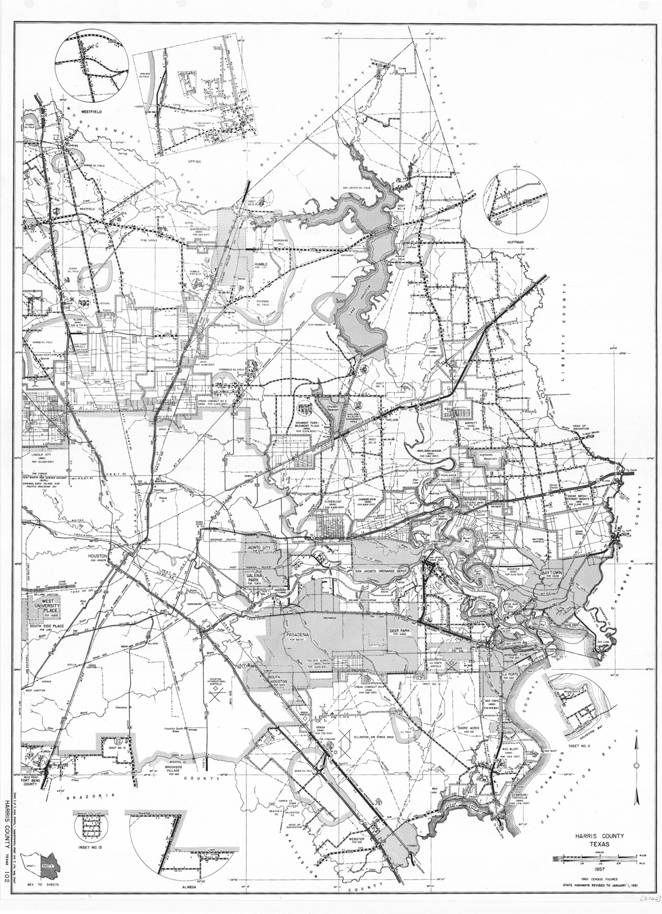
General Highway Map, Harris County, Texas
-
Map/Doc
79502
-
Collection
Texas State Library and Archives
-
Object Dates
1961 (Creation Date)
-
People and Organizations
Texas State Highway Department (Publisher)
-
Counties
Harris
-
Subjects
County
-
Height x Width
24.9 x 18.0 inches
63.3 x 45.7 cm
-
Comments
Prints available courtesy of the Texas State Library and Archives.
More info can be found here: TSLAC Map 05162
Part of: Texas State Library and Archives
Grandfield Bridge Sheet

Print $20.00
Grandfield Bridge Sheet
1920
Size 39.4 x 35.8 inches
Map/Doc 79751
General Highway Map, Andrews County, Texas

Print $20.00
General Highway Map, Andrews County, Texas
1961
Size 25.1 x 18.3 inches
Map/Doc 79347
General Highway Map, Harris County, Texas

Print $20.00
General Highway Map, Harris County, Texas
1939
Size 25.3 x 18.7 inches
Map/Doc 79116
Gulf Coast of the United States, Key West to Rio Grande

Print $40.00
Gulf Coast of the United States, Key West to Rio Grande
1863
Size 30.2 x 53.5 inches
Map/Doc 79335
General Highway Map. Detail of Cities and Towns in Lubbock County, Texas [Lubbock and vicinity]
![79181, General Highway Map. Detail of Cities and Towns in Lubbock County, Texas [Lubbock and vicinity], Texas State Library and Archives](https://historictexasmaps.com/wmedia_w700/maps/79181.tif.jpg)
Print $20.00
General Highway Map. Detail of Cities and Towns in Lubbock County, Texas [Lubbock and vicinity]
1940
Size 18.3 x 24.8 inches
Map/Doc 79181
[Reverse of] Plan of the City of Austin
![76228, [Reverse of] Plan of the City of Austin, Texas State Library and Archives](https://historictexasmaps.com/wmedia_w700/maps/76228.tif.jpg)
Print $20.00
[Reverse of] Plan of the City of Austin
1839
Size 19.2 x 24.3 inches
Map/Doc 76228
General Highway Map. Detail of Cities and Towns in McLennan County, Texas [Waco and vicinity]
![79192, General Highway Map. Detail of Cities and Towns in McLennan County, Texas [Waco and vicinity], Texas State Library and Archives](https://historictexasmaps.com/wmedia_w700/maps/79192.tif.jpg)
Print $20.00
General Highway Map. Detail of Cities and Towns in McLennan County, Texas [Waco and vicinity]
1940
Size 18.2 x 24.7 inches
Map/Doc 79192
General Highway Map, Milam County, Texas

Print $20.00
General Highway Map, Milam County, Texas
1961
Size 18.1 x 24.6 inches
Map/Doc 79597
Rand McNally Standard Map of Texas (reverse)

Print $20.00
Rand McNally Standard Map of Texas (reverse)
1923
Size 39.8 x 27.2 inches
Map/Doc 76229
General Highway Map, Harris County, Texas

Print $20.00
General Highway Map, Harris County, Texas
1961
Size 24.7 x 18.0 inches
Map/Doc 79501
General Highway Map, Victoria County, Texas

Print $20.00
General Highway Map, Victoria County, Texas
1961
Size 25.0 x 18.3 inches
Map/Doc 79697
General Highway Map, Tyler County, Texas

Print $20.00
General Highway Map, Tyler County, Texas
1940
Size 24.8 x 18.1 inches
Map/Doc 79264
You may also like
[Drawings of individual counties for Pressler and Langermann's 1879 Map of Texas]
![2140, [Drawings of individual counties for Pressler and Langermann's 1879 Map of Texas], General Map Collection](https://historictexasmaps.com/wmedia_w700/maps/2140-1.tif.jpg)
Print $20.00
- Digital $50.00
[Drawings of individual counties for Pressler and Langermann's 1879 Map of Texas]
1878
Size 28.5 x 42.0 inches
Map/Doc 2140

Wichita County

Print $20.00
- Digital $50.00
Wichita County
1892
Size 20.2 x 24.3 inches
Map/Doc 75804
Henderson County Working Sketch 29

Print $20.00
- Digital $50.00
Henderson County Working Sketch 29
1961
Size 39.3 x 41.9 inches
Map/Doc 66162
Val Verde County Sketch File Z13

Print $4.00
- Digital $50.00
Val Verde County Sketch File Z13
1898
Size 11.5 x 8.6 inches
Map/Doc 39142
Live Oak County Rolled Sketch 6

Print $20.00
- Digital $50.00
Live Oak County Rolled Sketch 6
1947
Size 43.6 x 25.9 inches
Map/Doc 6634
Travis County Rolled Sketch 22

Print $20.00
- Digital $50.00
Travis County Rolled Sketch 22
1937
Size 23.4 x 26.1 inches
Map/Doc 8023
Val Verde County Sketch File Z8

Print $20.00
- Digital $50.00
Val Verde County Sketch File Z8
1884
Size 25.2 x 19.9 inches
Map/Doc 12553
Flight Mission No. CLL-1N, Frame 35, Willacy County

Print $20.00
- Digital $50.00
Flight Mission No. CLL-1N, Frame 35, Willacy County
1954
Size 18.5 x 22.1 inches
Map/Doc 87016
St. L. S-W. Ry. of Texas Map of Lufkin Branch in Angelina County, Texas

Print $20.00
- Digital $50.00
St. L. S-W. Ry. of Texas Map of Lufkin Branch in Angelina County, Texas
1913
Size 24.0 x 12.1 inches
Map/Doc 64562
Map of the Passo Cavallo on the entrance into Matagorda Bay from the Gulf of Mexico

Print $20.00
- Digital $50.00
Map of the Passo Cavallo on the entrance into Matagorda Bay from the Gulf of Mexico
1839
Size 18.4 x 26.9 inches
Map/Doc 72764
[State Capitol Leagues and County School Leagues]
![92475, [State Capitol Leagues and County School Leagues], Twichell Survey Records](https://historictexasmaps.com/wmedia_w700/maps/92475-1.tif.jpg)
Print $20.00
- Digital $50.00
[State Capitol Leagues and County School Leagues]
Size 19.4 x 11.8 inches
Map/Doc 92475