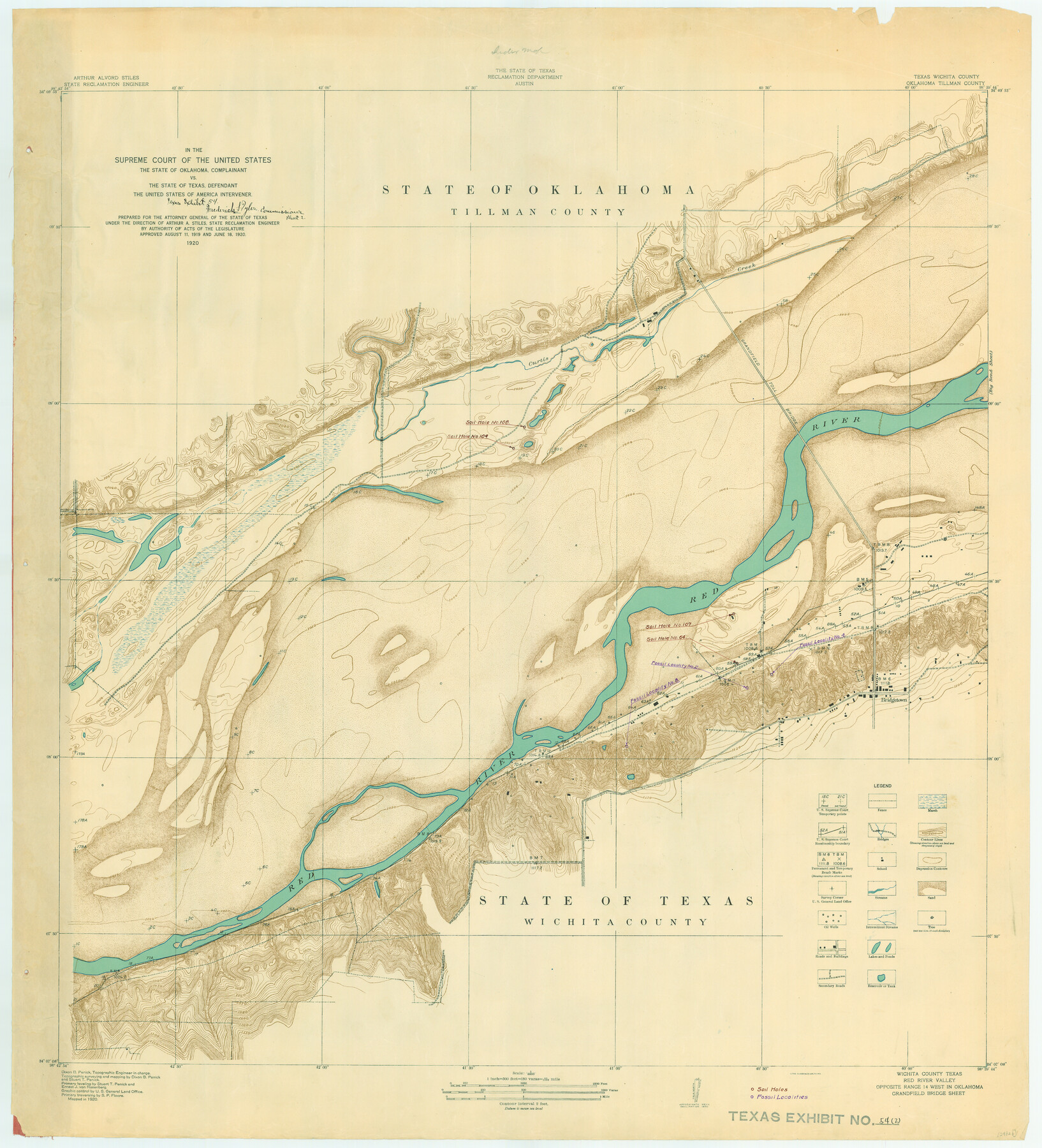
Grandfield Bridge Sheet
-
Map/Doc
79751
-
Collection
Texas State Library and Archives
-
Object Dates
1920 (Creation Date)
-
People and Organizations
State Reclamation Department (Publisher)
Arthur Alvord Stiles (Author)
Stuart T. Penick (Surveyor/Engineer)
Dixon B. Penick (Surveyor/Engineer)
-
Counties
Wichita
-
Subjects
Legal River Surveys Texas Boundaries Topographic
-
Height x Width
39.4 x 35.8 inches
100.1 x 90.9 cm
-
Comments
Prints available courtesy of the Texas State Library and Archives.
More info can be found here: TSLAC Map 02982b
Part of: Texas State Library and Archives
Texas Oil and Gas Fields and Truck Pipe Line Systems

Print $20.00
Texas Oil and Gas Fields and Truck Pipe Line Systems
1926
Size 21.7 x 30.8 inches
Map/Doc 79327
General Highway Map, Kendall County, Texas

Print $20.00
General Highway Map, Kendall County, Texas
1961
Size 18.3 x 24.6 inches
Map/Doc 79549
General Highway Map, Cameron County, Texas

Print $20.00
General Highway Map, Cameron County, Texas
1940
Size 18.4 x 25.3 inches
Map/Doc 79038
Mapa Original de Texas por El Ciudadano Estevan F. Austin Presentado al Exmo. Sr. Presidente por su autor 1829

Print $20.00
Mapa Original de Texas por El Ciudadano Estevan F. Austin Presentado al Exmo. Sr. Presidente por su autor 1829
1829
Size 33.4 x 28.1 inches
Map/Doc 76201
General Highway Map. Detail of Cities and Towns in Henderson County, Texas

Print $20.00
General Highway Map. Detail of Cities and Towns in Henderson County, Texas
1939
Size 18.6 x 25.0 inches
Map/Doc 79126
General Highway Map, Taylor County, Texas

Print $20.00
General Highway Map, Taylor County, Texas
1940
Size 18.6 x 25.0 inches
Map/Doc 79254
General Highway Map, San Patricio County, Texas

Print $20.00
General Highway Map, San Patricio County, Texas
1961
Size 18.1 x 24.5 inches
Map/Doc 79647
General Highway Map, Delta County, Hopkins County, Texas

Print $20.00
General Highway Map, Delta County, Hopkins County, Texas
1940
Size 25.2 x 18.5 inches
Map/Doc 79073
General Highway Map. Detail of Cities and Towns in Nacogdoches County, Texas [Nacogdoches and vicinity]
![79609, General Highway Map. Detail of Cities and Towns in Nacogdoches County, Texas [Nacogdoches and vicinity], Texas State Library and Archives](https://historictexasmaps.com/wmedia_w700/maps/79609.tif.jpg)
Print $20.00
General Highway Map. Detail of Cities and Towns in Nacogdoches County, Texas [Nacogdoches and vicinity]
1961
Size 19.3 x 25.0 inches
Map/Doc 79609
Preliminary Chart of the Entrance to Brazos River, Texas

Print $20.00
Preliminary Chart of the Entrance to Brazos River, Texas
1858
Size 17.9 x 21.3 inches
Map/Doc 76249
General Highway Map, Tom Green County, Texas

Print $20.00
General Highway Map, Tom Green County, Texas
1940
Size 24.9 x 18.3 inches
Map/Doc 79259
General Highway Map, Kimble County, Texas

Print $20.00
General Highway Map, Kimble County, Texas
1940
Size 24.9 x 18.3 inches
Map/Doc 79159
You may also like
Cherokee County Rolled Sketch 2

Print $20.00
- Digital $50.00
Cherokee County Rolled Sketch 2
1954
Size 44.6 x 36.0 inches
Map/Doc 8596
Cherokee County Working Sketch 21

Print $40.00
- Digital $50.00
Cherokee County Working Sketch 21
1969
Size 37.6 x 57.0 inches
Map/Doc 67976
Pecos County Rolled Sketch 64

Print $20.00
- Digital $50.00
Pecos County Rolled Sketch 64
Size 16.4 x 26.5 inches
Map/Doc 7235
Matagorda County Rolled Sketch PHL1

Print $20.00
- Digital $50.00
Matagorda County Rolled Sketch PHL1
Size 36.5 x 39.1 inches
Map/Doc 9477
Lampasas County Sketch File 6

Print $4.00
- Digital $50.00
Lampasas County Sketch File 6
1871
Size 8.0 x 6.8 inches
Map/Doc 29400
Grayson County Sketch File 25

Print $6.00
- Digital $50.00
Grayson County Sketch File 25
Size 8.4 x 7.1 inches
Map/Doc 24507
Pecos County Rolled Sketch 59

Print $20.00
- Digital $50.00
Pecos County Rolled Sketch 59
1922
Size 16.6 x 17.0 inches
Map/Doc 7231
Dallas County Sketch File 2

Print $8.00
- Digital $50.00
Dallas County Sketch File 2
1855
Size 5.6 x 4.5 inches
Map/Doc 20396
Packery Channel

Print $20.00
- Digital $50.00
Packery Channel
1974
Size 16.5 x 20.6 inches
Map/Doc 3003
Maps of Gulf Intracoastal Waterway, Texas - Sabine River to the Rio Grande and connecting waterways including ship channels

Print $20.00
- Digital $50.00
Maps of Gulf Intracoastal Waterway, Texas - Sabine River to the Rio Grande and connecting waterways including ship channels
1966
Size 14.5 x 22.3 inches
Map/Doc 61948
Medina County Rolled Sketch 11

Print $20.00
- Digital $50.00
Medina County Rolled Sketch 11
Size 27.4 x 25.6 inches
Map/Doc 6745
