Val Verde County Sketch File Z8
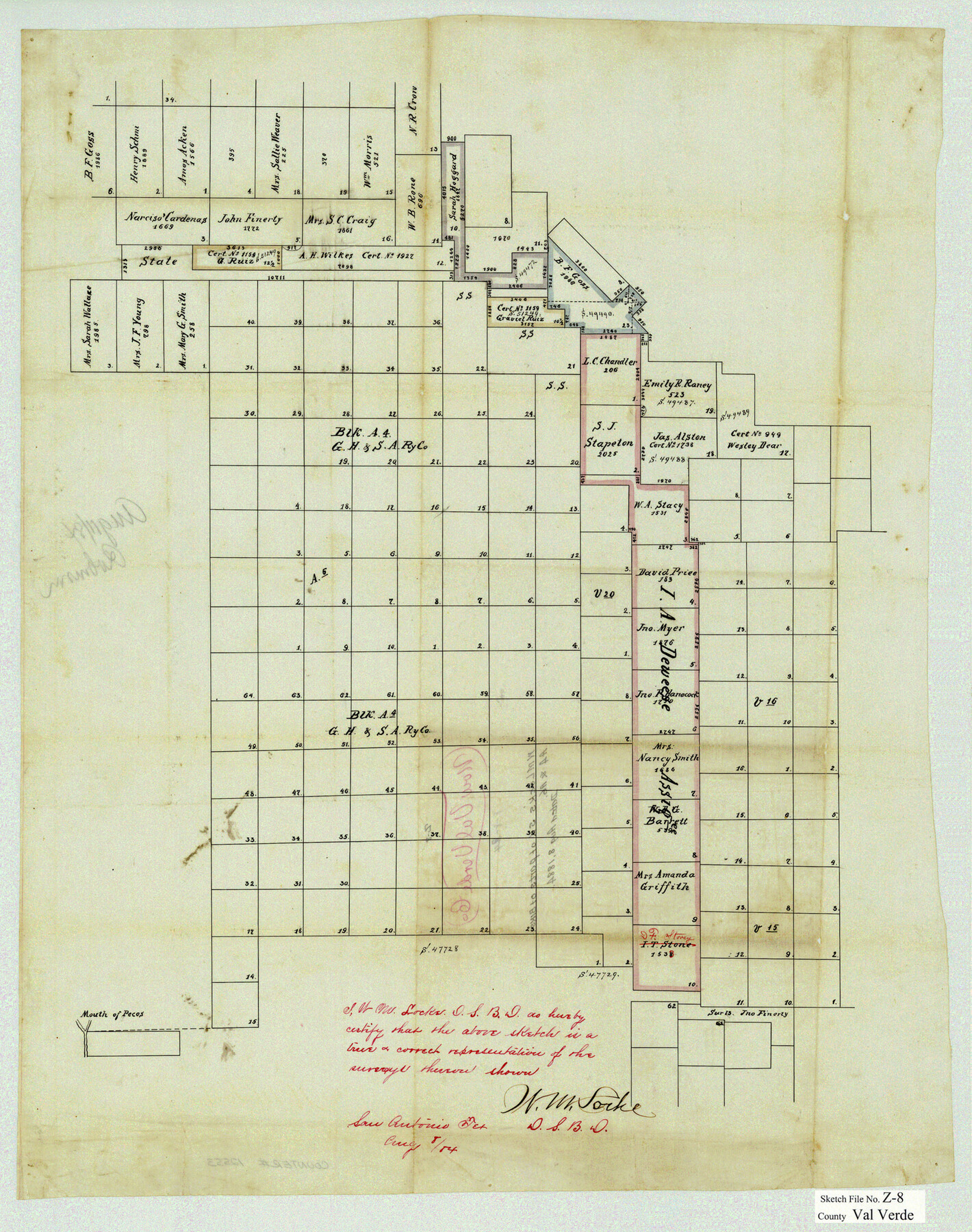
[Sketch of parts of Block A4 and surrounding area northwest from Del Rio]
-
Map/Doc
12553
-
Collection
General Map Collection
-
Object Dates
8/8/1884 (Creation Date)
-
People and Organizations
W.M. Locke (Surveyor/Engineer)
-
Counties
Val Verde
-
Subjects
Surveying Sketch File
-
Height x Width
25.2 x 19.9 inches
64.0 x 50.6 cm
-
Medium
paper, manuscript
-
Features
Pecos River
Part of: General Map Collection
Houston County Working Sketch 11

Print $20.00
- Digital $50.00
Houston County Working Sketch 11
1953
Size 28.5 x 24.5 inches
Map/Doc 66241
Real County Working Sketch 59

Print $20.00
- Digital $50.00
Real County Working Sketch 59
1962
Size 27.4 x 40.7 inches
Map/Doc 71951
Van Zandt County Sketch File 46

Print $2.00
- Digital $50.00
Van Zandt County Sketch File 46
Size 8.0 x 12.7 inches
Map/Doc 39503
Austin County Sketch File 1

Print $4.00
- Digital $50.00
Austin County Sketch File 1
Size 8.0 x 6.5 inches
Map/Doc 13853
J. De Cordova's Map of the State of Texas Compiled from the records of the General Land Office of the State

Print $20.00
- Digital $50.00
J. De Cordova's Map of the State of Texas Compiled from the records of the General Land Office of the State
1851
Size 34.9 x 32.0 inches
Map/Doc 442
Van Zandt County Sketch File 32

Print $4.00
- Digital $50.00
Van Zandt County Sketch File 32
1860
Size 12.2 x 7.9 inches
Map/Doc 39465
South Part Presidio County

Print $20.00
- Digital $50.00
South Part Presidio County
1975
Size 31.6 x 37.2 inches
Map/Doc 77400
Presidio County Working Sketch 47

Print $20.00
- Digital $50.00
Presidio County Working Sketch 47
1950
Size 30.2 x 39.5 inches
Map/Doc 71724
Galveston County Rolled Sketch 34

Print $20.00
- Digital $50.00
Galveston County Rolled Sketch 34
1979
Size 28.0 x 39.7 inches
Map/Doc 5966
Map of Anderson County

Print $20.00
- Digital $50.00
Map of Anderson County
1895
Size 46.7 x 37.5 inches
Map/Doc 4866
Crosby County Working Sketch 5

Print $20.00
- Digital $50.00
Crosby County Working Sketch 5
1911
Size 23.3 x 16.7 inches
Map/Doc 68439
Flight Mission No. DQO-2K, Frame 139, Galveston County

Print $20.00
- Digital $50.00
Flight Mission No. DQO-2K, Frame 139, Galveston County
1952
Size 18.8 x 22.5 inches
Map/Doc 85036
You may also like
Map of the Texas and Pacific Railway and connections

Print $20.00
- Digital $50.00
Map of the Texas and Pacific Railway and connections
1925
Size 8.2 x 9.3 inches
Map/Doc 95772
The Republic County of Fayette. May 3, 1838

Print $20.00
The Republic County of Fayette. May 3, 1838
2020
Size 14.7 x 21.7 inches
Map/Doc 96132
Brooks County Boundary File 1a

Print $40.00
- Digital $50.00
Brooks County Boundary File 1a
Size 63.8 x 7.1 inches
Map/Doc 50836
Upton County Working Sketch 43

Print $40.00
- Digital $50.00
Upton County Working Sketch 43
1962
Size 56.8 x 42.7 inches
Map/Doc 69539
[East line of Wheeler County along Oklahoma]
![89824, [East line of Wheeler County along Oklahoma], Twichell Survey Records](https://historictexasmaps.com/wmedia_w700/maps/89824-1.tif.jpg)
Print $40.00
- Digital $50.00
[East line of Wheeler County along Oklahoma]
Size 8.4 x 62.2 inches
Map/Doc 89824
Wheeler County Working Sketch 5

Print $40.00
- Digital $50.00
Wheeler County Working Sketch 5
1972
Size 55.3 x 45.9 inches
Map/Doc 72494
Stonewall County Working Sketch 8

Print $20.00
- Digital $50.00
Stonewall County Working Sketch 8
1950
Size 23.5 x 23.2 inches
Map/Doc 62315
Newton County Rolled Sketch 16

Print $20.00
- Digital $50.00
Newton County Rolled Sketch 16
Size 30.5 x 21.9 inches
Map/Doc 6846
Moore County Rolled Sketch 13

Print $20.00
- Digital $50.00
Moore County Rolled Sketch 13
1920
Size 25.8 x 33.3 inches
Map/Doc 6829
Approaches to Galveston Bay

Print $40.00
- Digital $50.00
Approaches to Galveston Bay
1989
Size 37.1 x 55.6 inches
Map/Doc 69887
Randall County Sketch File 12

Print $6.00
- Digital $50.00
Randall County Sketch File 12
1945
Size 11.3 x 8.9 inches
Map/Doc 34976
El Paso County Boundary File 22

Print $4.00
- Digital $50.00
El Paso County Boundary File 22
Size 13.6 x 8.6 inches
Map/Doc 53216