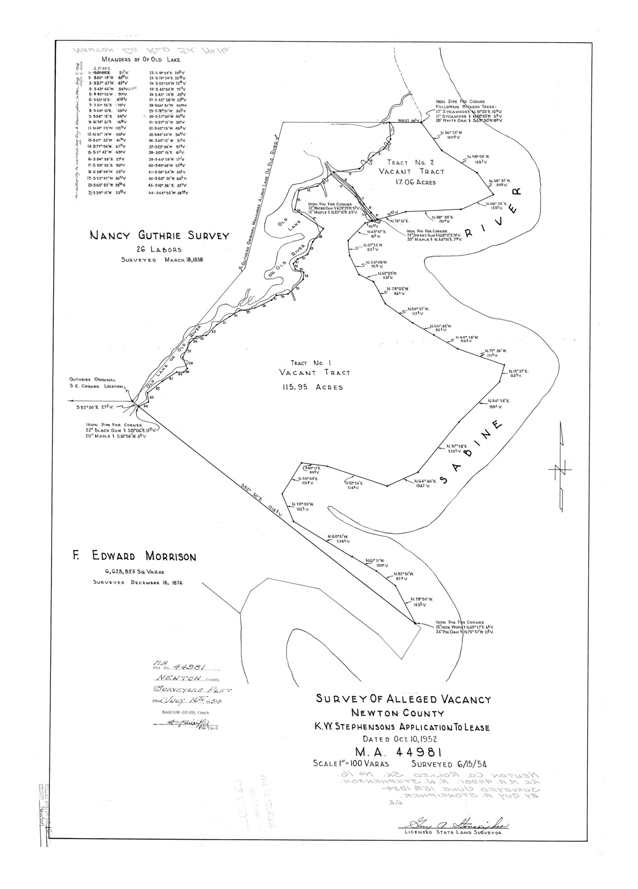
Newton County Rolled Sketch 16
Survey of alleged vacancy, Newton County, K.W. Stephensons application to lease dated Oct. 10, 1952, MA-44981
-
Map/Doc
6846
-
Collection
General Map Collection
-
Object Dates
1954/6/15 (Survey Date)
1954/7/16 (File Date)
-
People and Organizations
Guy A. Stonecipher (Surveyor/Engineer)
-
Counties
Newton
-
Subjects
Surveying Rolled Sketch
-
Height x Width
30.5 x 21.9 inches
77.5 x 55.6 cm
-
Scale
1" = 100 varas
Part of: General Map Collection
Jones County Boundary File 1b

Print $40.00
- Digital $50.00
Jones County Boundary File 1b
1882
Size 37.5 x 12.6 inches
Map/Doc 44359
Bee County Sketch File 33

Print $56.00
- Digital $50.00
Bee County Sketch File 33
Size 11.3 x 8.9 inches
Map/Doc 14349
Flight Mission No. DQN-2K, Frame 156, Calhoun County

Print $20.00
- Digital $50.00
Flight Mission No. DQN-2K, Frame 156, Calhoun County
1953
Size 18.5 x 22.3 inches
Map/Doc 84318
Deaf Smith County Sketch File 1 1/2

Print $20.00
- Digital $50.00
Deaf Smith County Sketch File 1 1/2
Size 20.7 x 17.1 inches
Map/Doc 11302
Deaf Smith County

Print $40.00
- Digital $50.00
Deaf Smith County
1926
Size 41.4 x 54.3 inches
Map/Doc 1816
Maps of Gulf Intracoastal Waterway, Texas - Sabine River to the Rio Grande and connecting waterways including ship channels

Print $20.00
- Digital $50.00
Maps of Gulf Intracoastal Waterway, Texas - Sabine River to the Rio Grande and connecting waterways including ship channels
1966
Size 14.5 x 22.3 inches
Map/Doc 61942
Kingston South Quadrangle

Print $20.00
- Digital $50.00
Kingston South Quadrangle
1999
Size 35.4 x 23.4 inches
Map/Doc 97364

Map of Maverick County

Print $20.00
- Digital $50.00
Map of Maverick County
1875
Size 36.3 x 23.7 inches
Map/Doc 3849

Palo Pinto County Rolled Sketch 13

Print $20.00
- Digital $50.00
Palo Pinto County Rolled Sketch 13
1986
Size 29.0 x 32.2 inches
Map/Doc 7193
Johnson's Military Map of the United States showing the Forts, Military Posts & all the Military Divisions with enlarged plans of southern harbors

Print $20.00
- Digital $50.00
Johnson's Military Map of the United States showing the Forts, Military Posts & all the Military Divisions with enlarged plans of southern harbors
1861
Map/Doc 93947
You may also like
Gillespie County

Print $40.00
- Digital $50.00
Gillespie County
1887
Size 44.1 x 59.7 inches
Map/Doc 16835
Culberson County Rolled Sketch 38A

Print $20.00
- Digital $50.00
Culberson County Rolled Sketch 38A
Size 27.2 x 30.0 inches
Map/Doc 5662
Flight Mission No. BRA-16M, Frame 172, Jefferson County

Print $20.00
- Digital $50.00
Flight Mission No. BRA-16M, Frame 172, Jefferson County
1953
Size 18.6 x 22.3 inches
Map/Doc 85770
![88925, Map of Duval Co[unty], Library of Congress](https://historictexasmaps.com/wmedia_w700/maps/88925-1.tif.jpg)
[Gulf Colorado & Santa Fe from 2178+36.0 to 3901+06.2]
![64698, [Gulf Colorado & Santa Fe from 2178+36.0 to 3901+06.2], General Map Collection](https://historictexasmaps.com/wmedia_w700/maps/64698.tif.jpg)
Print $40.00
- Digital $50.00
[Gulf Colorado & Santa Fe from 2178+36.0 to 3901+06.2]
Size 123.0 x 32.2 inches
Map/Doc 64698
Terrell County Working Sketch 65

Print $40.00
- Digital $50.00
Terrell County Working Sketch 65
1972
Size 49.0 x 44.8 inches
Map/Doc 69586
Live Oak County Sketch File 16

Print $4.00
- Digital $50.00
Live Oak County Sketch File 16
Size 4.6 x 7.1 inches
Map/Doc 30282
Presidio County Working Sketch 70

Print $20.00
- Digital $50.00
Presidio County Working Sketch 70
1961
Size 46.8 x 37.4 inches
Map/Doc 71747
Map of Spearman Lands

Print $20.00
- Digital $50.00
Map of Spearman Lands
Size 20.1 x 15.3 inches
Map/Doc 90791
Jasper County Rolled Sketch 5

Print $20.00
- Digital $50.00
Jasper County Rolled Sketch 5
1948
Size 29.0 x 24.4 inches
Map/Doc 6352
Flight Mission No. CUG-1P, Frame 166, Kleberg County

Print $20.00
- Digital $50.00
Flight Mission No. CUG-1P, Frame 166, Kleberg County
1956
Size 18.8 x 22.4 inches
Map/Doc 86173
Flight Mission No. BRA-3M, Frame 118, Jefferson County

Print $20.00
- Digital $50.00
Flight Mission No. BRA-3M, Frame 118, Jefferson County
1953
Size 18.6 x 22.3 inches
Map/Doc 85392