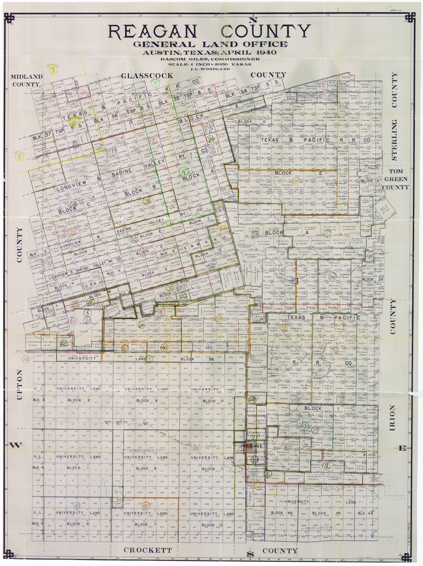
Reagan County Working Sketch Graphic Index
-
Map/Doc
76677
-
Collection
General Map Collection
-
Object Dates
4/1940 (Creation Date)
-
People and Organizations
J.L. Woodland (Draftsman)
-
Counties
Reagan
-
Subjects
County Surveying Working Sketch
-
Height x Width
48.3 x 36.7 inches
122.7 x 93.2 cm
-
Scale
1" = 2000 varas
Part of: General Map Collection

Webb County Sketch File 1-1

Print $4.00
- Digital $50.00
Webb County Sketch File 1-1
1857
Size 8.6 x 8.4 inches
Map/Doc 39708
Polk County Working Sketch 30

Print $20.00
- Digital $50.00
Polk County Working Sketch 30
1960
Size 18.2 x 24.4 inches
Map/Doc 71646
Wharton County Sketch File 6

Print $4.00
- Digital $50.00
Wharton County Sketch File 6
1877
Size 8.6 x 14.2 inches
Map/Doc 39923
Webb County Rolled Sketch 47

Print $20.00
- Digital $50.00
Webb County Rolled Sketch 47
Size 23.5 x 31.7 inches
Map/Doc 8203
Northeast Part Pecos County

Print $20.00
- Digital $50.00
Northeast Part Pecos County
1975
Size 35.8 x 42.3 inches
Map/Doc 73260
El Paso County Working Sketch 55

Print $20.00
- Digital $50.00
El Paso County Working Sketch 55
1992
Size 44.2 x 36.3 inches
Map/Doc 69077
Hudspeth County Rolled Sketch 66

Print $20.00
- Digital $50.00
Hudspeth County Rolled Sketch 66
1973
Size 11.7 x 18.2 inches
Map/Doc 6263
Kaufman County Sketch File 5

Print $22.00
- Digital $50.00
Kaufman County Sketch File 5
1849
Size 7.6 x 12.6 inches
Map/Doc 28632
Refugio County Boundary File 74

Print $172.00
- Digital $50.00
Refugio County Boundary File 74
Size 9.3 x 4.4 inches
Map/Doc 58272
Briscoe County Sketch File 5

Print $40.00
- Digital $50.00
Briscoe County Sketch File 5
Size 29.8 x 26.5 inches
Map/Doc 10994
Kleberg County Rolled Sketch 10-22

Print $20.00
- Digital $50.00
Kleberg County Rolled Sketch 10-22
1952
Size 35.1 x 36.8 inches
Map/Doc 9376
You may also like
Mitchell County Sketch File 10

Print $4.00
- Digital $50.00
Mitchell County Sketch File 10
1909
Size 11.3 x 8.8 inches
Map/Doc 31698
Post Route Map of the State of Texas with adjacent parts of Louisiana, Arkansas, Indian Territory, and of the Republic of Mexico showing post offices with the intermediate and mail routes in operation on the 1st of December, 1892

Print $40.00
- Digital $50.00
Post Route Map of the State of Texas with adjacent parts of Louisiana, Arkansas, Indian Territory, and of the Republic of Mexico showing post offices with the intermediate and mail routes in operation on the 1st of December, 1892
1889
Size 44.0 x 57.3 inches
Map/Doc 94080
Clay County Sketch File 38

Print $4.00
- Digital $50.00
Clay County Sketch File 38
Size 16.4 x 25.0 inches
Map/Doc 11092
Newton County Sketch File 8

Print $4.00
- Digital $50.00
Newton County Sketch File 8
Size 11.0 x 9.0 inches
Map/Doc 32376
Houston Ship Channel, Alexander Island to Carpenter Bayou

Print $40.00
- Digital $50.00
Houston Ship Channel, Alexander Island to Carpenter Bayou
1992
Size 35.3 x 49.3 inches
Map/Doc 69917
McMullen County Rolled Sketch 12

Print $20.00
- Digital $50.00
McMullen County Rolled Sketch 12
Size 26.5 x 33.2 inches
Map/Doc 6729
Reagan County Sketch File 35

Print $6.00
- Digital $50.00
Reagan County Sketch File 35
1962
Size 14.4 x 8.7 inches
Map/Doc 35032
Eastern South America Brazil, Paraguay, Uruguay, and the Guianas

Eastern South America Brazil, Paraguay, Uruguay, and the Guianas
1955
Size 29.8 x 41.2 inches
Map/Doc 92389
Map of the Rio Grande & Eagle Pass Ry. from Sections 21-25 9/10 Inclusive, Webb County

Print $40.00
- Digital $50.00
Map of the Rio Grande & Eagle Pass Ry. from Sections 21-25 9/10 Inclusive, Webb County
1909
Size 25.8 x 55.4 inches
Map/Doc 64658
Rusk County Sketch File 44

Print $12.00
Rusk County Sketch File 44
1951
Size 11.3 x 8.9 inches
Map/Doc 35585
Austin County Sketch File A

Print $40.00
- Digital $50.00
Austin County Sketch File A
1895
Size 22.3 x 21.1 inches
Map/Doc 10878
Map of Anderson County

Print $20.00
- Digital $50.00
Map of Anderson County
1876
Size 19.4 x 21.9 inches
Map/Doc 3228