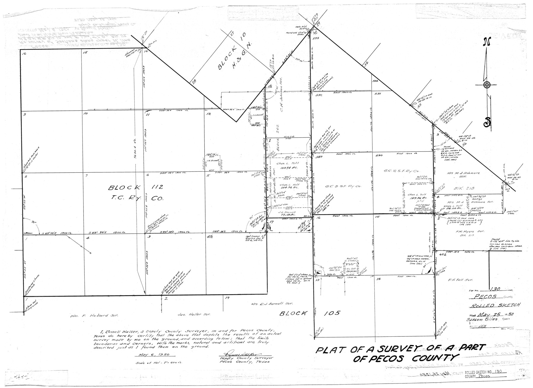
Pecos County Rolled Sketch 130
Plat of a survey of a part of Pecos County [showing part of Block 112, T. C. Ry. Co. and surrounding area]
-
Map/Doc
7268
-
Collection
General Map Collection
-
Object Dates
5/6/1950 (Creation Date)
5/25/1950 (File Date)
-
People and Organizations
Russell Walker (Surveyor/Engineer)
-
Counties
Pecos
-
Subjects
Surveying Rolled Sketch
-
Height x Width
20.1 x 27.7 inches
51.1 x 70.4 cm
-
Scale
1" = 600 varas
Part of: General Map Collection
No. 1 - Survey for a road from the Brazo Santiago to the Rio Grande

Print $20.00
- Digital $50.00
No. 1 - Survey for a road from the Brazo Santiago to the Rio Grande
1847
Size 18.4 x 27.3 inches
Map/Doc 72875
El Paso County Working Sketch 20

Print $20.00
- Digital $50.00
El Paso County Working Sketch 20
1960
Size 28.3 x 26.1 inches
Map/Doc 69042
Gray County Boundary File 11

Print $80.00
- Digital $50.00
Gray County Boundary File 11
Size 20.7 x 19.7 inches
Map/Doc 53912
Archer County Working Sketch 9

Print $20.00
- Digital $50.00
Archer County Working Sketch 9
1924
Size 22.2 x 29.8 inches
Map/Doc 67149
Mapa del Rio Grande desde su Desembocadura en el Golfo hasta San Vicente, Presidio Antíguo

Print $20.00
- Digital $50.00
Mapa del Rio Grande desde su Desembocadura en el Golfo hasta San Vicente, Presidio Antíguo
1873
Size 38.1 x 32.3 inches
Map/Doc 97126
Gaines County Working Sketch 28

Print $20.00
- Digital $50.00
Gaines County Working Sketch 28
1982
Size 20.9 x 24.6 inches
Map/Doc 69328
Controlled Mosaic by Jack Amman Photogrammetric Engineers, Inc - Sheet 47

Print $20.00
- Digital $50.00
Controlled Mosaic by Jack Amman Photogrammetric Engineers, Inc - Sheet 47
1954
Size 20.0 x 24.0 inches
Map/Doc 83506
Tarrant County Sketch File 29

Print $4.00
- Digital $50.00
Tarrant County Sketch File 29
1879
Size 7.9 x 11.6 inches
Map/Doc 37745
Duval County Working Sketch 51

Print $20.00
- Digital $50.00
Duval County Working Sketch 51
1986
Size 27.3 x 35.3 inches
Map/Doc 68775
2017 Official Travel Map, Texas

2017 Official Travel Map, Texas
2017
Size 33.6 x 36.4 inches
Map/Doc 94415
Throckmorton County Rolled Sketch 6A

Print $20.00
- Digital $50.00
Throckmorton County Rolled Sketch 6A
2004
Size 20.3 x 24.3 inches
Map/Doc 82489
Wharton County Sketch File 25

Print $4.00
- Digital $50.00
Wharton County Sketch File 25
1978
Size 11.1 x 8.7 inches
Map/Doc 39988
You may also like
Webb County Working Sketch 82

Print $40.00
- Digital $50.00
Webb County Working Sketch 82
1979
Size 32.9 x 62.9 inches
Map/Doc 72449
Map of Africa designed to accompany Smith's Geography for Schools

Print $20.00
- Digital $50.00
Map of Africa designed to accompany Smith's Geography for Schools
1850
Size 9.7 x 12.0 inches
Map/Doc 93897
San Jacinto County Rolled Sketch 14

Print $20.00
- Digital $50.00
San Jacinto County Rolled Sketch 14
1998
Size 28.0 x 40.0 inches
Map/Doc 7565
Map of Harrison County

Print $20.00
- Digital $50.00
Map of Harrison County
1880
Size 20.4 x 21.8 inches
Map/Doc 1119
Martin County Working Sketch 10

Print $40.00
- Digital $50.00
Martin County Working Sketch 10
1971
Size 50.0 x 37.4 inches
Map/Doc 70828
Newton County Working Sketch 44

Print $20.00
- Digital $50.00
Newton County Working Sketch 44
1992
Size 19.2 x 24.6 inches
Map/Doc 71290
Texas Hill Country Trail Region

Texas Hill Country Trail Region
2017
Size 18.2 x 24.3 inches
Map/Doc 96871
Right of Way & Track Map, St. Louis, Brownsville & Mexico Ry. operated by St. Louis, Brownsville & Mexico Ry. Co.

Print $40.00
- Digital $50.00
Right of Way & Track Map, St. Louis, Brownsville & Mexico Ry. operated by St. Louis, Brownsville & Mexico Ry. Co.
1919
Size 25.8 x 56.9 inches
Map/Doc 64620
[Meander of Yellow House Creek from Northeast Corner of Section 37, Block S to Northeast corner of Section 3, Block O]
![91387, [Meander of Yellow House Creek from Northeast Corner of Section 37, Block S to Northeast corner of Section 3, Block O], Twichell Survey Records](https://historictexasmaps.com/wmedia_w700/maps/91387-1.tif.jpg)
Print $20.00
- Digital $50.00
[Meander of Yellow House Creek from Northeast Corner of Section 37, Block S to Northeast corner of Section 3, Block O]
Size 24.8 x 32.7 inches
Map/Doc 91387
Dickens County Sketch File 28

Print $23.00
- Digital $50.00
Dickens County Sketch File 28
Size 14.5 x 9.0 inches
Map/Doc 21005
Flight Mission No. BQR-20K, Frame 8, Brazoria County

Print $20.00
- Digital $50.00
Flight Mission No. BQR-20K, Frame 8, Brazoria County
1952
Size 18.6 x 22.3 inches
Map/Doc 84110
No. 2 Chart of Corpus Christi Pass, Texas

Print $20.00
- Digital $50.00
No. 2 Chart of Corpus Christi Pass, Texas
1878
Size 18.4 x 27.3 inches
Map/Doc 73016