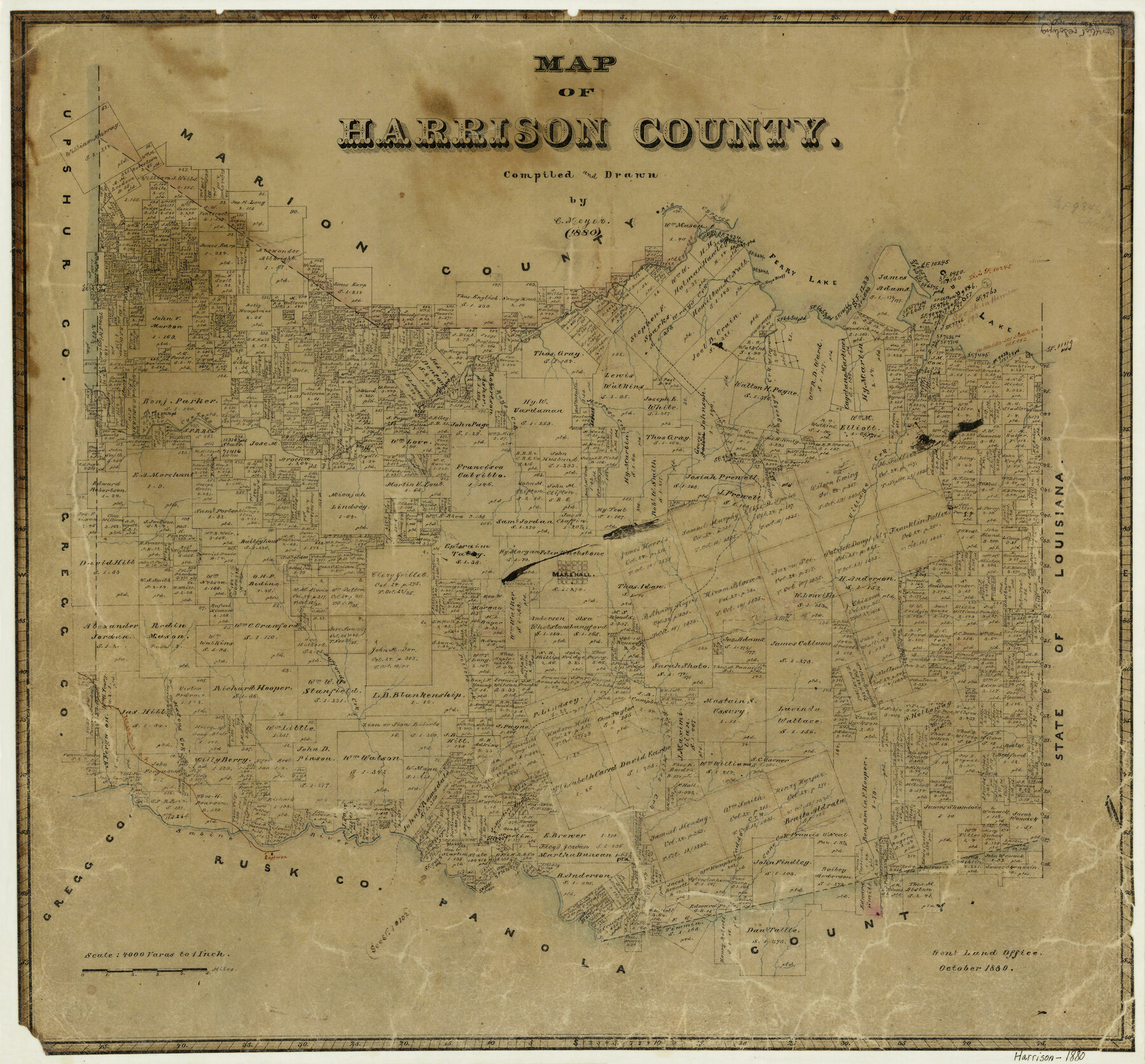
Map of Harrison County
-
Map/Doc
1119
-
Collection
General Map Collection
-
Object Dates
10/1880 (Creation Date)
-
People and Organizations
C. Meyer (Draftsman)
-
Counties
Harrison
-
Subjects
County
-
Height x Width
20.4 x 21.8 inches
51.8 x 55.4 cm
-
Features
Morriss Creek
Rays Bluff
Caddo Lake
Ferry Lake
Village Creek
Hagertys Creek
Cane Creek
Caddo Creek
Eight Miles Creek
Marshall
Little Cypress Creek
Rays Creek
Wrays Creek
Big Cypress Creek
Potter's Creek
Duffords Creek
Eastway
Sabine River
Masons Creek
T&G
Part of: General Map Collection
G. C. & S. F. Ry. Alinement [sic] and Right of Way Map of Dallas Branch, Johnson County, Texas
![64652, G. C. & S. F. Ry. Alinement [sic] and Right of Way Map of Dallas Branch, Johnson County, Texas, General Map Collection](https://historictexasmaps.com/wmedia_w700/maps/64652.tif.jpg)
Print $40.00
- Digital $50.00
G. C. & S. F. Ry. Alinement [sic] and Right of Way Map of Dallas Branch, Johnson County, Texas
1925
Size 37.6 x 87.9 inches
Map/Doc 64652
Henderson County Sketch File 12

Print $8.00
- Digital $50.00
Henderson County Sketch File 12
1871
Size 8.4 x 7.4 inches
Map/Doc 26349
Kinney County Sketch File 26

Print $20.00
- Digital $50.00
Kinney County Sketch File 26
1928
Size 20.4 x 18.8 inches
Map/Doc 11945
Sectional Map No. 4 of the lands and of the lines of the Texas & Pacific R'Y. Co. in El Paso and part of Presidio Co's.

Print $20.00
- Digital $50.00
Sectional Map No. 4 of the lands and of the lines of the Texas & Pacific R'Y. Co. in El Paso and part of Presidio Co's.
1885
Size 22.3 x 17.0 inches
Map/Doc 2304
Edwards County Working Sketch 79

Print $40.00
- Digital $50.00
Edwards County Working Sketch 79
1962
Size 58.5 x 26.6 inches
Map/Doc 68955
Hall County Sketch File 10

Print $20.00
- Digital $50.00
Hall County Sketch File 10
1884
Size 19.6 x 22.1 inches
Map/Doc 11605
Roberts County Rolled Sketch 2

Print $20.00
- Digital $50.00
Roberts County Rolled Sketch 2
Size 25.8 x 29.4 inches
Map/Doc 7511
The North Part of America Conteyning Newfoundland, New England, Virginia, Florida, New Spaine, and Nova Francia

Print $20.00
- Digital $50.00
The North Part of America Conteyning Newfoundland, New England, Virginia, Florida, New Spaine, and Nova Francia
1625
Size 12.6 x 16.2 inches
Map/Doc 97028
Mills County Working Sketch 5

Print $3.00
- Digital $50.00
Mills County Working Sketch 5
1914
Size 13.1 x 10.8 inches
Map/Doc 71035
Ector County Rolled Sketch HLG

Print $20.00
- Digital $50.00
Ector County Rolled Sketch HLG
1937
Size 45.2 x 30.2 inches
Map/Doc 8835

Rusk County Working Sketch 10

Print $20.00
- Digital $50.00
Rusk County Working Sketch 10
1980
Size 22.4 x 20.6 inches
Map/Doc 63645
You may also like
South Part of Brewster Co.

Print $40.00
- Digital $50.00
South Part of Brewster Co.
1955
Size 48.8 x 40.0 inches
Map/Doc 66736
Flight Mission No. BRA-7M, Frame 206, Jefferson County

Print $20.00
- Digital $50.00
Flight Mission No. BRA-7M, Frame 206, Jefferson County
1953
Size 18.6 x 22.2 inches
Map/Doc 85574
Flight Mission No. DIX-10P, Frame 179, Aransas County

Print $20.00
- Digital $50.00
Flight Mission No. DIX-10P, Frame 179, Aransas County
1956
Size 18.7 x 22.3 inches
Map/Doc 83969
Sketch Portion of Lamb County, Texas

Print $20.00
- Digital $50.00
Sketch Portion of Lamb County, Texas
1924
Size 19.9 x 21.4 inches
Map/Doc 92176
[Surveys in Austin's Colony on the east side of the Colorado River]
![167, [Surveys in Austin's Colony on the east side of the Colorado River], General Map Collection](https://historictexasmaps.com/wmedia_w700/maps/167.tif.jpg)
Print $20.00
- Digital $50.00
[Surveys in Austin's Colony on the east side of the Colorado River]
1830
Size 30.9 x 25.1 inches
Map/Doc 167
Harris County Sketch File 74

Print $22.00
- Digital $50.00
Harris County Sketch File 74
1944
Size 17.1 x 12.2 inches
Map/Doc 25543
The Republic County of Harrison. February 1, 1842

Print $20.00
The Republic County of Harrison. February 1, 1842
2020
Size 18.6 x 21.7 inches
Map/Doc 96172
Burnet County Working Sketch 5

Print $20.00
- Digital $50.00
Burnet County Working Sketch 5
1956
Size 30.0 x 19.3 inches
Map/Doc 67848
Flight Mission No. DQO-7K, Frame 84, Galveston County

Print $20.00
- Digital $50.00
Flight Mission No. DQO-7K, Frame 84, Galveston County
1952
Size 18.8 x 22.5 inches
Map/Doc 85111
Maps of Gulf Intracoastal Waterway, Texas - Sabine River to the Rio Grande and connecting waterways including ship channels

Print $20.00
- Digital $50.00
Maps of Gulf Intracoastal Waterway, Texas - Sabine River to the Rio Grande and connecting waterways including ship channels
1966
Size 14.5 x 22.2 inches
Map/Doc 61940
Flight Mission No. CRC-3R, Frame 46, Chambers County

Print $20.00
- Digital $50.00
Flight Mission No. CRC-3R, Frame 46, Chambers County
1956
Size 18.6 x 22.5 inches
Map/Doc 84819
Young County Rolled Sketch 6

Print $20.00
- Digital $50.00
Young County Rolled Sketch 6
Size 43.4 x 30.8 inches
Map/Doc 8294