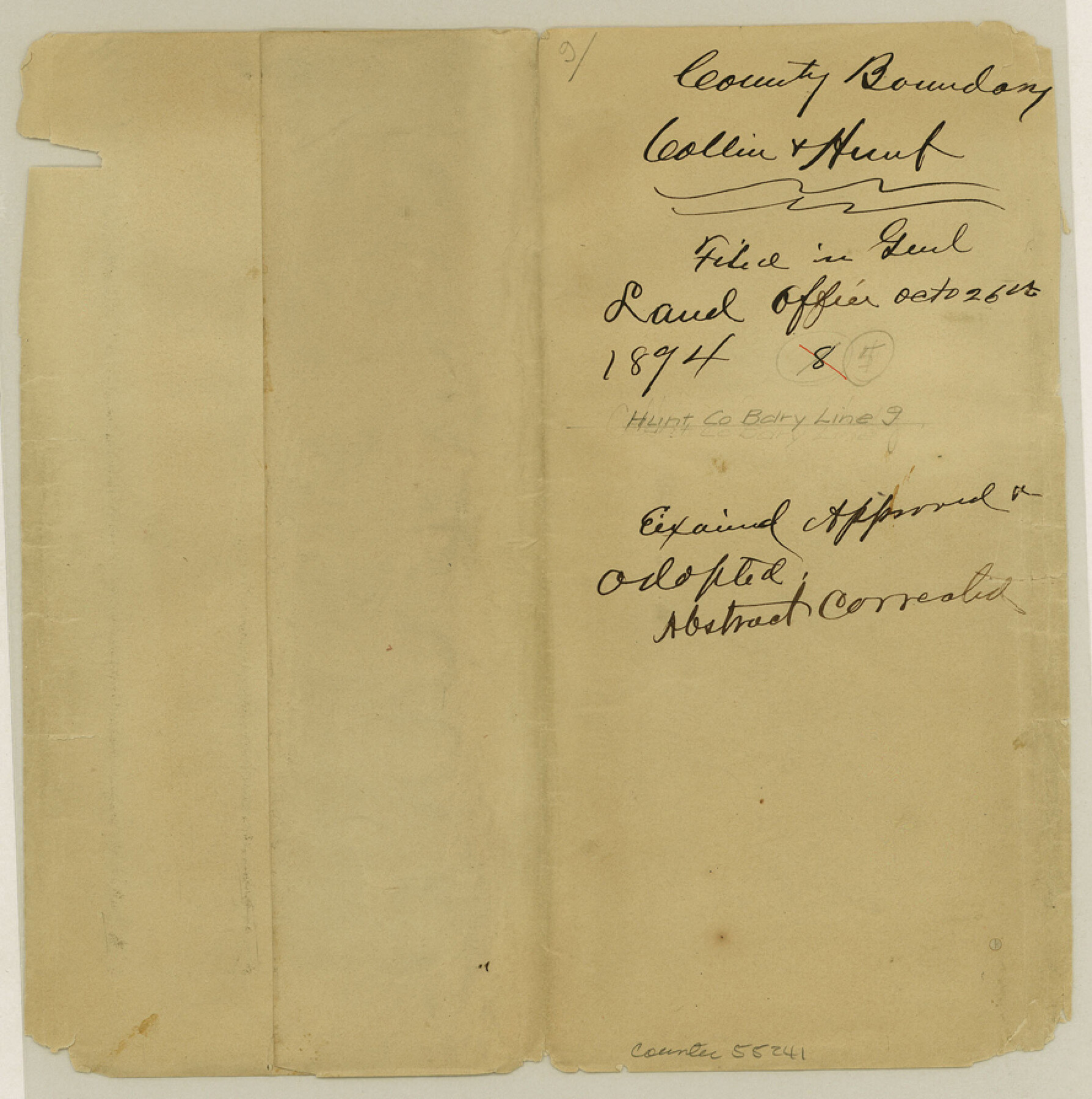
Hunt County Boundary File 9
Co. Line between Collin & Hunt Co's
-
Map/Doc
55241
-
Collection
General Map Collection
-
Counties
Hunt
-
Subjects
County Boundaries
-
Height x Width
8.9 x 8.9 inches
22.6 x 22.6 cm
Part of: General Map Collection
[Beaumont, Sour Lake and Western Ry. Right of Way and Alignment - Frisco]
![64114, [Beaumont, Sour Lake and Western Ry. Right of Way and Alignment - Frisco], General Map Collection](https://historictexasmaps.com/wmedia_w700/maps/64114.tif.jpg)
Print $20.00
- Digital $50.00
[Beaumont, Sour Lake and Western Ry. Right of Way and Alignment - Frisco]
1910
Size 19.9 x 46.0 inches
Map/Doc 64114
Lipscomb County Rolled Sketch 5

Print $40.00
- Digital $50.00
Lipscomb County Rolled Sketch 5
Size 60.5 x 8.0 inches
Map/Doc 81427
Fayette County Working Sketch 5

Print $20.00
- Digital $50.00
Fayette County Working Sketch 5
1981
Size 16.2 x 14.6 inches
Map/Doc 69169
Reeves County Rolled Sketch 10

Print $20.00
- Digital $50.00
Reeves County Rolled Sketch 10
Size 22.4 x 42.0 inches
Map/Doc 7480
Jack County Sketch File 18a

Print $4.00
- Digital $50.00
Jack County Sketch File 18a
Size 8.0 x 12.8 inches
Map/Doc 27555
Bandera County Working Sketch 36

Print $20.00
- Digital $50.00
Bandera County Working Sketch 36
1966
Size 22.5 x 29.5 inches
Map/Doc 67632
Val Verde County Rolled Sketch 81

Print $20.00
- Digital $50.00
Val Verde County Rolled Sketch 81
Size 35.0 x 44.7 inches
Map/Doc 10088
[Location Survey of the Southern Kansas Railway, Kiowa Extension from a point in Drake's Location, in Indian Territory 100 miles from south line of Kansas, continuing up Wolf Creek and South Canadian River to Cottonwood Creek in Hutchinson County]
![88841, [Location Survey of the Southern Kansas Railway, Kiowa Extension from a point in Drake's Location, in Indian Territory 100 miles from south line of Kansas, continuing up Wolf Creek and South Canadian River to Cottonwood Creek in Hutchinson County], General Map Collection](https://historictexasmaps.com/wmedia_w700/maps/88841.tif.jpg)
Print $20.00
- Digital $50.00
[Location Survey of the Southern Kansas Railway, Kiowa Extension from a point in Drake's Location, in Indian Territory 100 miles from south line of Kansas, continuing up Wolf Creek and South Canadian River to Cottonwood Creek in Hutchinson County]
1886
Size 39.1 x 42.0 inches
Map/Doc 88841
Map of Germany, Switzerland and Northern Italy engraved to illustrate Mitchell's school and family geography

Print $20.00
- Digital $50.00
Map of Germany, Switzerland and Northern Italy engraved to illustrate Mitchell's school and family geography
1840
Size 11.8 x 9.5 inches
Map/Doc 93504
Kerr County Rolled Sketch 19

Print $20.00
- Digital $50.00
Kerr County Rolled Sketch 19
1954
Size 43.4 x 28.4 inches
Map/Doc 6501
Bandera County Working Sketch 32

Print $20.00
- Digital $50.00
Bandera County Working Sketch 32
1956
Size 22.7 x 18.4 inches
Map/Doc 67628
Flight Mission No. CRC-2R, Frame 62, Chambers County

Print $20.00
- Digital $50.00
Flight Mission No. CRC-2R, Frame 62, Chambers County
1956
Size 18.6 x 22.5 inches
Map/Doc 84733
You may also like
DeWitt Empresario Colony. April 15, 1825

Print $20.00
DeWitt Empresario Colony. April 15, 1825
2020
Size 18.1 x 21.7 inches
Map/Doc 95991
Brazos River, Jones Bridge Special Map Sheet

Print $4.00
- Digital $50.00
Brazos River, Jones Bridge Special Map Sheet
1936
Size 29.8 x 28.2 inches
Map/Doc 65280
Bexar County Sketch File 36

Print $14.00
- Digital $50.00
Bexar County Sketch File 36
1868
Size 8.8 x 7.6 inches
Map/Doc 14500
Flight Mission No. BRE-2P, Frame 105, Nueces County

Print $20.00
- Digital $50.00
Flight Mission No. BRE-2P, Frame 105, Nueces County
1956
Size 18.4 x 22.2 inches
Map/Doc 86790
Flight Mission No. DAH-17M, Frame 68, Orange County

Print $20.00
- Digital $50.00
Flight Mission No. DAH-17M, Frame 68, Orange County
1953
Size 18.6 x 22.4 inches
Map/Doc 86902
Map of Darrington State Farm, Brazoria County, Texas

Print $20.00
- Digital $50.00
Map of Darrington State Farm, Brazoria County, Texas
Size 18.5 x 37.9 inches
Map/Doc 62985
Sterling County Sketch File D

Print $8.00
- Digital $50.00
Sterling County Sketch File D
Size 11.2 x 8.6 inches
Map/Doc 37157
Dickens County

Print $20.00
- Digital $50.00
Dickens County
1891
Size 25.7 x 20.6 inches
Map/Doc 3488
France Baker Farm

Print $3.00
- Digital $50.00
France Baker Farm
Size 9.5 x 12.0 inches
Map/Doc 92332
Dimmit County Rolled Sketch 11

Print $20.00
- Digital $50.00
Dimmit County Rolled Sketch 11
1942
Size 21.8 x 28.9 inches
Map/Doc 5720
Hood County Sketch File 19

Print $11.00
- Digital $50.00
Hood County Sketch File 19
Size 9.0 x 7.9 inches
Map/Doc 26603
[Blocks M27 and 1T along border with Oklahoma (North line of County)]
![93144, [Blocks M27 and 1T along border with Oklahoma (North line of County)], Twichell Survey Records](https://historictexasmaps.com/wmedia_w700/maps/93144-1.tif.jpg)
Print $40.00
- Digital $50.00
[Blocks M27 and 1T along border with Oklahoma (North line of County)]
Size 107.3 x 8.6 inches
Map/Doc 93144