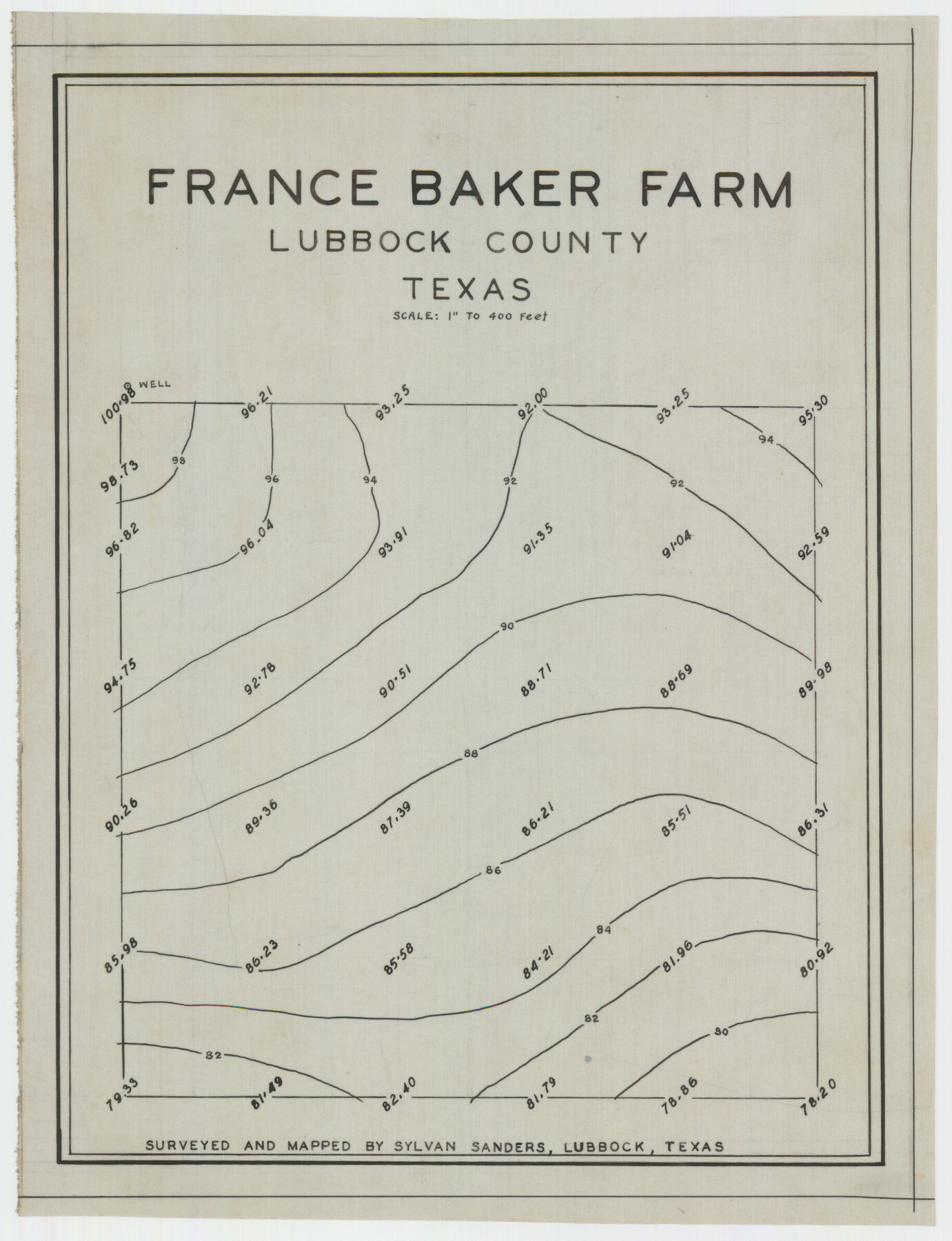
France Baker Farm
-
Map/Doc
92332
-
Collection
Twichell Survey Records
-
People and Organizations
Sylvan Sanders (Surveyor/Engineer)
-
Counties
Lubbock
-
Height x Width
9.5 x 12.0 inches
24.1 x 30.5 cm
Part of: Twichell Survey Records
Yates Pool, Pecos County, Texas

Print $3.00
- Digital $50.00
Yates Pool, Pecos County, Texas
1928
Size 11.5 x 10.3 inches
Map/Doc 91674
Plat Showing Land Owned by City of Lubbock out of Section 3, Block O

Print $20.00
- Digital $50.00
Plat Showing Land Owned by City of Lubbock out of Section 3, Block O
Size 40.4 x 31.1 inches
Map/Doc 92876

[Central Garza County]
![92659, [Central Garza County], Twichell Survey Records](https://historictexasmaps.com/wmedia_w700/maps/92659-1.tif.jpg)
Print $20.00
- Digital $50.00
[Central Garza County]
1906
Size 28.0 x 33.1 inches
Map/Doc 92659
[John H. Tyler and Bob Reid Strip Surveys in Yates Field]
![91582, [John H. Tyler and Bob Reid Strip Surveys in Yates Field], Twichell Survey Records](https://historictexasmaps.com/wmedia_w700/maps/91582-1.tif.jpg)
Print $2.00
- Digital $50.00
[John H. Tyler and Bob Reid Strip Surveys in Yates Field]
Size 14.3 x 8.8 inches
Map/Doc 91582
Forester Cemetery

Print $20.00
- Digital $50.00
Forester Cemetery
1925
Size 23.0 x 28.8 inches
Map/Doc 92322
[Nathaniel H. Cochran Survey and Vicinity]
![91494, [Nathaniel H. Cochran Survey and Vicinity], Twichell Survey Records](https://historictexasmaps.com/wmedia_w700/maps/91494-1.tif.jpg)
Print $20.00
- Digital $50.00
[Nathaniel H. Cochran Survey and Vicinity]
Size 26.7 x 18.8 inches
Map/Doc 91494
[University Lands Blocks 16-18]
![91568, [University Lands Blocks 16-18], Twichell Survey Records](https://historictexasmaps.com/wmedia_w700/maps/91568-1.tif.jpg)
Print $20.00
- Digital $50.00
[University Lands Blocks 16-18]
Size 18.5 x 12.7 inches
Map/Doc 91568
[H. & T. C. Block 47]
![91834, [H. & T. C. Block 47], Twichell Survey Records](https://historictexasmaps.com/wmedia_w700/maps/91834-1.tif.jpg)
Print $20.00
- Digital $50.00
[H. & T. C. Block 47]
Size 19.4 x 18.5 inches
Map/Doc 91834

[H. & T. C. RR. Company, Block 47 and vicinity]
![91159, [H. & T. C. RR. Company, Block 47 and vicinity], Twichell Survey Records](https://historictexasmaps.com/wmedia_w700/maps/91159-1.tif.jpg)
Print $20.00
- Digital $50.00
[H. & T. C. RR. Company, Block 47 and vicinity]
Size 18.7 x 19.9 inches
Map/Doc 91159
[Sketch showing topography in vicinity of Yellow Point]
![92137, [Sketch showing topography in vicinity of Yellow Point], Twichell Survey Records](https://historictexasmaps.com/wmedia_w700/maps/92137-1.tif.jpg)
Print $20.00
- Digital $50.00
[Sketch showing topography in vicinity of Yellow Point]
Size 21.4 x 19.2 inches
Map/Doc 92137
You may also like


Montgomery County Rolled Sketch 39

Print $20.00
- Digital $50.00
Montgomery County Rolled Sketch 39
1967
Size 23.8 x 27.9 inches
Map/Doc 6813
[Sketch of Railroad Switchyard stretching from Ross to Monroe Streets, Amarillo, Texas]
![91830, [Sketch of Railroad Switchyard stretching from Ross to Monroe Streets, Amarillo, Texas], Twichell Survey Records](https://historictexasmaps.com/wmedia_w700/maps/91830-1.tif.jpg)
Print $20.00
- Digital $50.00
[Sketch of Railroad Switchyard stretching from Ross to Monroe Streets, Amarillo, Texas]
Size 10.0 x 36.1 inches
Map/Doc 91830
Map of Kinney County, Texas

Print $20.00
Map of Kinney County, Texas
1884
Size 25.4 x 35.2 inches
Map/Doc 88966
Somervell Co.

Print $20.00
- Digital $50.00
Somervell Co.
1884
Size 28.0 x 26.8 inches
Map/Doc 63040
Chambers County NRC Article 33.136 Sketch 15

Print $62.00
Chambers County NRC Article 33.136 Sketch 15
2025
Map/Doc 97510
Burnet County Rolled Sketch 4

Print $20.00
- Digital $50.00
Burnet County Rolled Sketch 4
1949
Size 31.9 x 17.5 inches
Map/Doc 5356
Cameron County Rolled Sketch 34

Print $20.00
- Digital $50.00
Cameron County Rolled Sketch 34
2000
Size 24.2 x 35.2 inches
Map/Doc 5397
Armstrong County Working Sketch Graphic Index

Print $20.00
- Digital $50.00
Armstrong County Working Sketch Graphic Index
1933
Size 40.3 x 40.0 inches
Map/Doc 76457
Calhoun County Rolled Sketch 12

Print $40.00
- Digital $50.00
Calhoun County Rolled Sketch 12
1940
Size 30.2 x 54.8 inches
Map/Doc 43619
Hutchinson County Working Sketch 49

Print $20.00
- Digital $50.00
Hutchinson County Working Sketch 49
1988
Size 35.2 x 37.3 inches
Map/Doc 66409