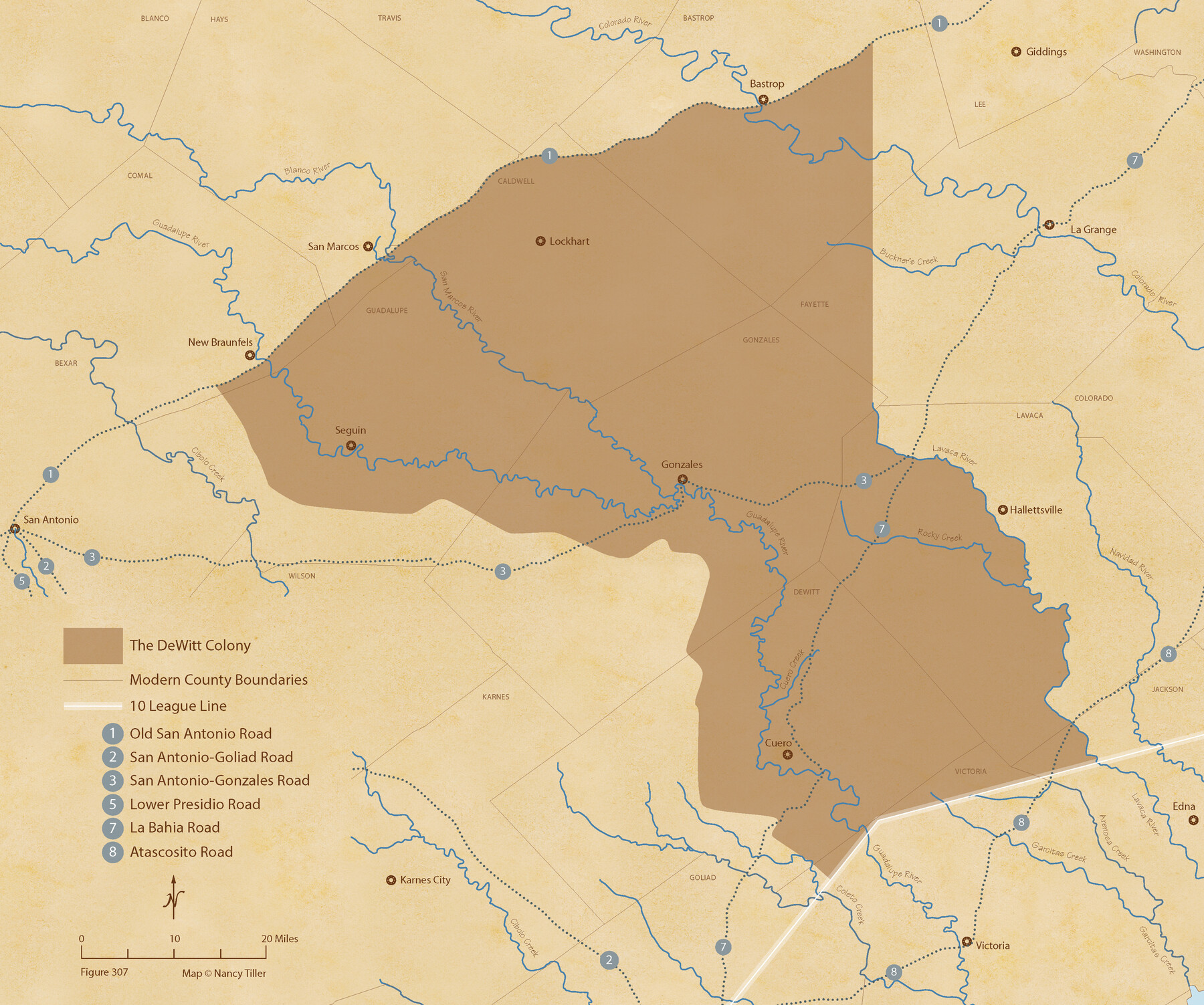
DeWitt Empresario Colony. April 15, 1825
Figure No. 307 from 'A Boundary Atlas of Texas, 1821-1845' by Jim Tiller
-
Map/Doc
95991
-
Collection
Nancy and Jim Tiller Digital Collection
-
Object Dates
2020/1/1 (Creation Date)
-
People and Organizations
Jim Tiller (Author)
Nancy Tiller (Cartographer)
Gang Gong (GIS Professional)
-
Subjects
Atlas Colony Mexican Texas Texas Boundaries
-
Height x Width
18.1 x 21.7 inches
46.0 x 55.1 cm
-
Medium
digital image
-
Comments
To purchase a digital PDF copy of "A Boundary Atlas of Texas, 1821-1845" see 96437.
Part of: Nancy and Jim Tiller Digital Collection
The Mexican Municipality of Matagorda. December 28, 1834

Print $20.00
The Mexican Municipality of Matagorda. December 28, 1834
2020
Size 15.9 x 21.7 inches
Map/Doc 96026
The Mexican Company Empresario Colony. May 1, 1832

Print $20.00
The Mexican Company Empresario Colony. May 1, 1832
2020
Size 15.0 x 21.7 inches
Map/Doc 95999

Cameron Empresario Colony. May 21, 1827

Print $20.00
Cameron Empresario Colony. May 21, 1827
2020
Size 10.7 x 21.7 inches
Map/Doc 95986
The Republic County of Colorado. Proposed, Late Fall 1837

Print $20.00
The Republic County of Colorado. Proposed, Late Fall 1837
2020
Size 18.4 x 21.7 inches
Map/Doc 96118
The Chief Justice County of Red River. Lands in Conflict with Nacogdoches County

Print $20.00
The Chief Justice County of Red River. Lands in Conflict with Nacogdoches County
2020
Size 17.4 x 21.8 inches
Map/Doc 96066
The Republic County of Travis. Spring 1842

Print $20.00
The Republic County of Travis. Spring 1842
2020
Size 20.8 x 21.6 inches
Map/Doc 96292
The Chief Justice County of Matagorda. March 30, 1837

Print $20.00
The Chief Justice County of Matagorda. March 30, 1837
2020
Size 19.7 x 21.7 inches
Map/Doc 96057
The Republic County of Nacogdoches. December 29, 1845

Print $20.00
The Republic County of Nacogdoches. December 29, 1845
2020
Size 15.9 x 21.8 inches
Map/Doc 96250
The Republic County of San Augustine. December 29, 1845

Print $20.00
The Republic County of San Augustine. December 29, 1845
2020
Size 18.8 x 21.7 inches
Map/Doc 96272
The Judicial District/County of Neches. Abolished, Spring 1842

Print $20.00
The Judicial District/County of Neches. Abolished, Spring 1842
2020
Size 15.5 x 21.7 inches
Map/Doc 96339
The Republic County of San Augustine. Boundaries Defined, December 14, 1837

Print $20.00
The Republic County of San Augustine. Boundaries Defined, December 14, 1837
2020
Size 18.8 x 21.7 inches
Map/Doc 96271
You may also like
The Republic County of Houston. December 6, 1841

Print $20.00
The Republic County of Houston. December 6, 1841
2020
Size 19.7 x 21.8 inches
Map/Doc 96180
Map of north end of Brazos Island

Print $20.00
- Digital $50.00
Map of north end of Brazos Island
Size 27.7 x 18.3 inches
Map/Doc 72907
Nueces County Sketch File 12c

Print $11.00
- Digital $50.00
Nueces County Sketch File 12c
1889
Size 12.6 x 8.2 inches
Map/Doc 32534
North Part of El Paso Co.

Print $20.00
- Digital $50.00
North Part of El Paso Co.
1977
Size 35.7 x 46.3 inches
Map/Doc 73141

[Galveston, Harrisburg & San Antonio Railroad from Cuero to Stockdale]
![64183, [Galveston, Harrisburg & San Antonio Railroad from Cuero to Stockdale], General Map Collection](https://historictexasmaps.com/wmedia_w700/maps/64183-GC.tif.jpg)
Print $20.00
- Digital $50.00
[Galveston, Harrisburg & San Antonio Railroad from Cuero to Stockdale]
1906
Size 13.6 x 34.0 inches
Map/Doc 64183
Presidio County Rolled Sketch 3B

Print $20.00
- Digital $50.00
Presidio County Rolled Sketch 3B
Size 26.2 x 24.1 inches
Map/Doc 7328
General Highway Map, Jim Wells County, Texas

Print $20.00
General Highway Map, Jim Wells County, Texas
1940
Size 18.4 x 24.8 inches
Map/Doc 79148
Baylor County Working Sketch 5

Print $20.00
- Digital $50.00
Baylor County Working Sketch 5
1940
Size 11.9 x 30.4 inches
Map/Doc 67290
Map of Aransas Co.

Print $20.00
- Digital $50.00
Map of Aransas Co.
1896
Size 38.8 x 36.8 inches
Map/Doc 4874
Galveston County NRC Article 33.136 Sketch 18

Print $66.00
- Digital $50.00
Galveston County NRC Article 33.136 Sketch 18
2003
Size 22.4 x 33.9 inches
Map/Doc 78545
The North Part of America

Print $20.00
- Digital $50.00
The North Part of America
1625
Size 13.1 x 14.8 inches
Map/Doc 93815