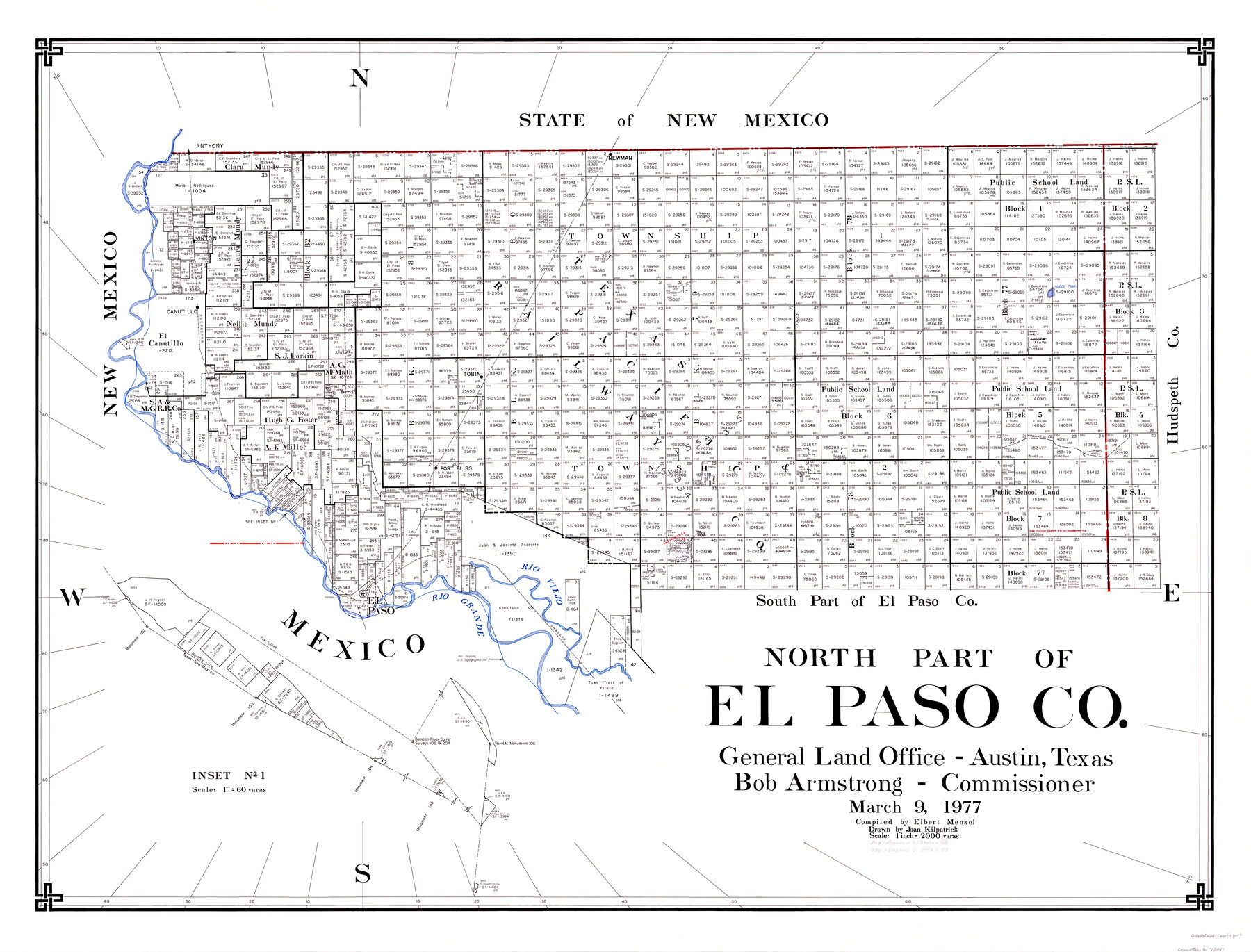
North Part of El Paso Co.
-
Map/Doc
73141
-
Collection
General Map Collection
-
Object Dates
3/9/1977 (Creation Date)
-
People and Organizations
Elbert Menzel (Compiler)
Bob Armstrong (GLO Commissioner)
Joan Kilpatrick (Draftsman)
-
Counties
El Paso
-
Subjects
County
-
Height x Width
35.7 x 46.3 inches
90.7 x 117.6 cm
-
Scale
1" = 2000 varas
-
Comments
Leroy lettered.
-
Features
Ysleta
Anthony
Vinton
EP&NE
Newman
Hueco Tanks Lake
Canutillo
Tobin
RGEP&SF
Fort Bliss
El Paso
Rio Grande
Rio Viejo
GH&SA
Part of: General Map Collection
Cooke County Sketch File 10

Print $4.00
- Digital $50.00
Cooke County Sketch File 10
1855
Size 13.0 x 8.4 inches
Map/Doc 19242
Cherokee County Sketch File 21

Print $4.00
- Digital $50.00
Cherokee County Sketch File 21
1876
Size 8.0 x 7.4 inches
Map/Doc 18165
Flight Mission No. CRC-4R, Frame 96, Chambers County

Print $20.00
- Digital $50.00
Flight Mission No. CRC-4R, Frame 96, Chambers County
1956
Size 18.4 x 22.2 inches
Map/Doc 84893
Williamson County

Print $40.00
- Digital $50.00
Williamson County
1946
Size 37.3 x 54.8 inches
Map/Doc 77460
Gregg County Sketch File 4

Print $20.00
- Digital $50.00
Gregg County Sketch File 4
1931
Size 22.1 x 16.6 inches
Map/Doc 11586
Andrews County Working Sketch 22

Print $40.00
- Digital $50.00
Andrews County Working Sketch 22
1979
Size 38.3 x 48.8 inches
Map/Doc 67068
Hardeman County

Print $20.00
- Digital $50.00
Hardeman County
1935
Size 46.0 x 42.7 inches
Map/Doc 95520
Dawson County Rolled Sketch 9

Print $20.00
- Digital $50.00
Dawson County Rolled Sketch 9
1953
Size 36.6 x 45.7 inches
Map/Doc 8773
Origins of Imports and Destination of Exports at Houston, Tex., during 1921

Print $20.00
- Digital $50.00
Origins of Imports and Destination of Exports at Houston, Tex., during 1921
1921
Size 14.2 x 23.1 inches
Map/Doc 97171
Kendall County Sketch File 11

Print $8.00
- Digital $50.00
Kendall County Sketch File 11
1924
Size 11.2 x 8.7 inches
Map/Doc 28695
Matagorda County Sketch File 47

Print $68.00
- Digital $50.00
Matagorda County Sketch File 47
Size 11.2 x 8.6 inches
Map/Doc 30976
Hale County Rolled Sketch 10

Print $40.00
- Digital $50.00
Hale County Rolled Sketch 10
Size 52.8 x 56.6 inches
Map/Doc 9096
You may also like


Nacogdoches County Working Sketch 6

Print $20.00
- Digital $50.00
Nacogdoches County Working Sketch 6
1955
Size 14.7 x 12.5 inches
Map/Doc 71222
Real County Working Sketch 65

Print $20.00
- Digital $50.00
Real County Working Sketch 65
1969
Size 31.1 x 23.4 inches
Map/Doc 71957
Green & Lumsden's Ranch

Print $20.00
- Digital $50.00
Green & Lumsden's Ranch
Size 28.9 x 25.1 inches
Map/Doc 92946
Darrington Plantation of the Texas Prison System, Brazoria County

Print $20.00
- Digital $50.00
Darrington Plantation of the Texas Prison System, Brazoria County
Size 16.9 x 37.4 inches
Map/Doc 62986
Irion County Rolled Sketch 22

Print $20.00
- Digital $50.00
Irion County Rolled Sketch 22
1936
Size 24.3 x 39.9 inches
Map/Doc 6330
Kinney County Sketch File 31

Print $40.00
- Digital $50.00
Kinney County Sketch File 31
1934
Size 15.3 x 13.6 inches
Map/Doc 29176
Map of Stephens County, Texas

Print $20.00
- Digital $50.00
Map of Stephens County, Texas
Size 36.8 x 40.1 inches
Map/Doc 93026
Kimble County Working Sketch 2

Print $20.00
- Digital $50.00
Kimble County Working Sketch 2
Size 20.6 x 17.9 inches
Map/Doc 70070
Loving County

Print $20.00
- Digital $50.00
Loving County
1932
Size 35.0 x 45.6 inches
Map/Doc 73225
Lee County Sketch File 1

Print $4.00
- Digital $50.00
Lee County Sketch File 1
1856
Size 13.1 x 8.2 inches
Map/Doc 29678