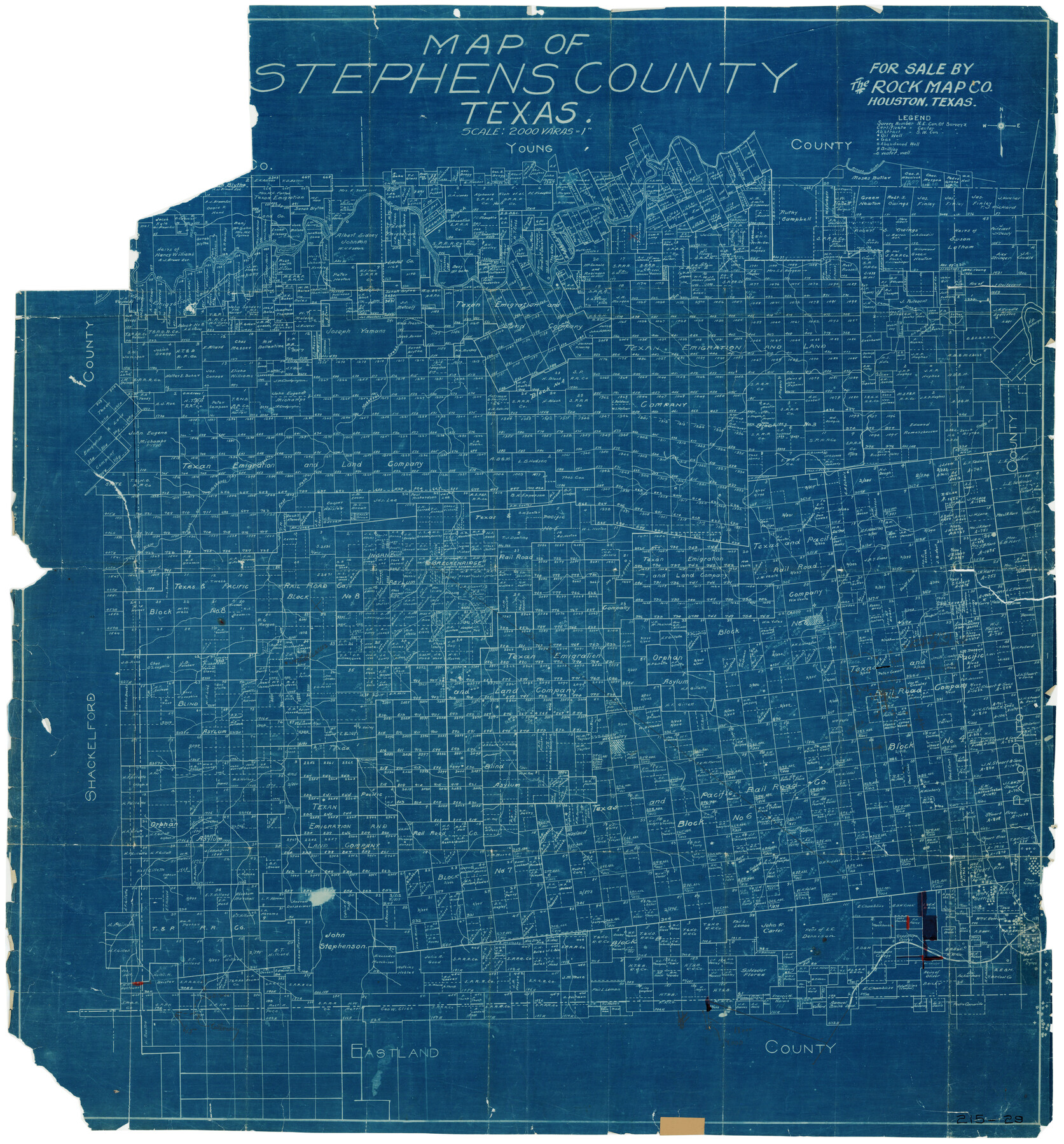
Map of Stephens County, Texas
215-29
- 
                          Map/Doc93026
- 
                            CollectionTwichell Survey Records
- 
                            People and OrganizationsThe Rock Map Co. (Publisher)
- 
                            CountiesStephens
- 
                            SubjectsCounty
- 
                            Height x Width36.8 x 40.1 inches93.5 x 101.9 cm
Part of: Twichell Survey Records
            [Blocks Z3, K5, 8, and 7]
            
                                    ![90590, [Blocks Z3, K5, 8, and 7], Twichell Survey Records](https://historictexasmaps.com/wmedia_w700/maps/90590-1.tif.jpg) 


    ![90590, [Blocks Z3, K5, 8, and 7], Twichell Survey Records](https://historictexasmaps.com/wmedia_w700/maps/90590-1.tif.jpg) 
                                
            
                                            Print $20.00                    
                                             -                         Digital $50.00                                    
                [Blocks Z3, K5, 8, and 7]
Size 11.7 x 19.3 inches
                                Map/Doc 90590
            
            [NE Quarter Section 11 Block CK Lubbock County, Texas]
            
                                    ![92871, [NE Quarter Section 11 Block CK Lubbock County, Texas], Twichell Survey Records](https://historictexasmaps.com/wmedia_w700/maps/92871-1.tif.jpg) 


    ![92871, [NE Quarter Section 11 Block CK Lubbock County, Texas], Twichell Survey Records](https://historictexasmaps.com/wmedia_w700/maps/92871-1.tif.jpg) 
                                
            
                                            Print $20.00                    
                                             -                         Digital $50.00                                    
                [NE Quarter Section 11 Block CK Lubbock County, Texas]
1949
Size 16.1 x 16.5 inches
                                Map/Doc 92871
            
            Pecos County, 1917


                                            Print $20.00                    
                                             -                         Digital $50.00                                    
                Pecos County, 1917
1917
Size 40.5 x 47.4 inches
                                Map/Doc 89707
            
            Lamb-Bailey County Line


                                            Print $40.00                    
                                             -                         Digital $50.00                                    
                Lamb-Bailey County Line
Size 15.9 x 53.3 inches
                                Map/Doc 89671
            
            [Block 37, Townships 1 and 2 North]
            
                                    ![91363, [Block 37, Townships 1 and 2 North], Twichell Survey Records](https://historictexasmaps.com/wmedia_w700/maps/91363-1.tif.jpg) 


    ![91363, [Block 37, Townships 1 and 2 North], Twichell Survey Records](https://historictexasmaps.com/wmedia_w700/maps/91363-1.tif.jpg) 
                                
            
                                            Print $20.00                    
                                             -                         Digital $50.00                                    
                [Block 37, Townships 1 and 2 North]
Size 19.7 x 40.9 inches
                                Map/Doc 91363
            
            [Blocks M8, M9, M11, W1, RC and A. & B. Block A]
            
                                    ![91931, [Blocks M8, M9, M11, W1, RC and A. & B. Block A], Twichell Survey Records](https://historictexasmaps.com/wmedia_w700/maps/91931-1.tif.jpg) 


    ![91931, [Blocks M8, M9, M11, W1, RC and A. & B. Block A], Twichell Survey Records](https://historictexasmaps.com/wmedia_w700/maps/91931-1.tif.jpg) 
                                
            
                                            Print $20.00                    
                                             -                         Digital $50.00                                    
                [Blocks M8, M9, M11, W1, RC and A. & B. Block A]
Size 32.0 x 25.2 inches
                                Map/Doc 91931
            
            [West and North lines of the Panhandle]
            
                                    ![90576, [West and North lines of the Panhandle], Twichell Survey Records](https://historictexasmaps.com/wmedia_w700/maps/90576-1.tif.jpg) 


    ![90576, [West and North lines of the Panhandle], Twichell Survey Records](https://historictexasmaps.com/wmedia_w700/maps/90576-1.tif.jpg) 
                                
            
                                            Print $20.00                    
                                             -                         Digital $50.00                                    
                [West and North lines of the Panhandle]
1885
Size 22.0 x 32.1 inches
                                Map/Doc 90576
            
            [Sketch N, showing H. & G. N. Block 7, and Blocks C-1 through C-5]
            
                                    ![91768, [Sketch N, showing H. & G. N. Block 7, and Blocks C-1 through C-5], Twichell Survey Records](https://historictexasmaps.com/wmedia_w700/maps/91768-1.tif.jpg) 


    ![91768, [Sketch N, showing H. & G. N. Block 7, and Blocks C-1 through C-5], Twichell Survey Records](https://historictexasmaps.com/wmedia_w700/maps/91768-1.tif.jpg) 
                                
            
                                            Print $20.00                    
                                             -                         Digital $50.00                                    
                [Sketch N, showing H. & G. N. Block 7, and Blocks C-1 through C-5]
Size 14.6 x 16.7 inches
                                Map/Doc 91768
            
            Waco Manufacturing Company Block 1, G. H. & H. Block 5, Capitol Leagues 229, 230, 234-237]
            
                                    ![90726, Waco Manufacturing Company Block 1, G. H. & H. Block 5, Capitol Leagues 229, 230, 234-237], Twichell Survey Records](https://historictexasmaps.com/wmedia_w700/maps/90726-1.tif.jpg) 


    ![90726, Waco Manufacturing Company Block 1, G. H. & H. Block 5, Capitol Leagues 229, 230, 234-237], Twichell Survey Records](https://historictexasmaps.com/wmedia_w700/maps/90726-1.tif.jpg) 
                                
            
                                            Print $20.00                    
                                             -                         Digital $50.00                                    
                Waco Manufacturing Company Block 1, G. H. & H. Block 5, Capitol Leagues 229, 230, 234-237]
1902
Size 14.5 x 21.6 inches
                                Map/Doc 90726
            
            [Wm. Baker and Chas. Lydings surveys and vicinity]
            
                                    ![92988, [Wm. Baker and Chas. Lydings surveys and vicinity], Twichell Survey Records](https://historictexasmaps.com/wmedia_w700/maps/92988-1.tif.jpg) 


    ![92988, [Wm. Baker and Chas. Lydings surveys and vicinity], Twichell Survey Records](https://historictexasmaps.com/wmedia_w700/maps/92988-1.tif.jpg) 
                                
            
                                            Print $2.00                    
                                             -                         Digital $50.00                                    
                [Wm. Baker and Chas. Lydings surveys and vicinity]
Size 6.6 x 7.0 inches
                                Map/Doc 92988
            
            [Blocks B5, B6 and Capitol Land Reservation]
            
                                    ![93014, [Blocks B5, B6 and Capitol Land Reservation], Twichell Survey Records](https://historictexasmaps.com/wmedia_w700/maps/93014-1.tif.jpg) 


    ![93014, [Blocks B5, B6 and Capitol Land Reservation], Twichell Survey Records](https://historictexasmaps.com/wmedia_w700/maps/93014-1.tif.jpg) 
                                
            
                                            Print $20.00                    
                                             -                         Digital $50.00                                    
                [Blocks B5, B6 and Capitol Land Reservation]
Size 20.6 x 18.6 inches
                                Map/Doc 93014
            
            Killian Subdivision of the Northeast Portion of Section 42, Block AK


                                            Print $20.00                    
                                             -                         Digital $50.00                                    
                Killian Subdivision of the Northeast Portion of Section 42, Block AK
Size 15.9 x 14.1 inches
                                Map/Doc 92267
            You may also like
            Archer County Sketch File B


                                            Print $18.00                    
                                             -                         Digital $50.00                                    
                Archer County Sketch File B
1892
Size 14.2 x 8.8 inches
                                Map/Doc 13566
            
            Crane County Rolled Sketch 22


                                            Print $20.00                    
                                             -                         Digital $50.00                                    
                Crane County Rolled Sketch 22
1990
Size 12.5 x 19.3 inches
                                Map/Doc 5578
            
            Flight Mission No. CZW-1R, Frame 165, Hardeman County


                                            Print $20.00                    
                                             -                         Digital $50.00                                    
                Flight Mission No. CZW-1R, Frame 165, Hardeman County
1956
Size 18.7 x 22.4 inches
                                Map/Doc 85236
            
            Liberty County Working Sketch 33


                                            Print $20.00                    
                                             -                         Digital $50.00                                    
                Liberty County Working Sketch 33
1954
Size 30.6 x 36.7 inches
                                Map/Doc 70492
            
            Panola County Working Sketch 22


                                            Print $20.00                    
                                             -                         Digital $50.00                                    
                Panola County Working Sketch 22
1951
Map/Doc 71431
            
            Reconnoissances of Routes from San Antonio de Bexar, El Paso del Norte &c &c


                                            Print $20.00                    
                                             -                         Digital $50.00                                    
                Reconnoissances of Routes from San Antonio de Bexar, El Paso del Norte &c &c
1849
Size 26.3 x 38.9 inches
                                Map/Doc 94853
            
            Current Miscellaneous File 39


                                            Print $20.00                    
                                             -                         Digital $50.00                                    
                Current Miscellaneous File 39
Size 11.2 x 8.8 inches
                                Map/Doc 73962
            
            Uvalde County Sketch File 20


                                            Print $40.00                    
                                             -                         Digital $50.00                                    
                Uvalde County Sketch File 20
1882
Size 15.0 x 13.2 inches
                                Map/Doc 39002
            
            Current Miscellaneous File 24


                                            Print $26.00                    
                                             -                         Digital $50.00                                    
                Current Miscellaneous File 24
1953
Size 10.6 x 8.2 inches
                                Map/Doc 73883
            
            San Saba County Sketch File 17


                                            Print $8.00                    
                                             -                         Digital $50.00                                    
                San Saba County Sketch File 17
1918
Size 11.4 x 8.8 inches
                                Map/Doc 36456
             
                         
                                