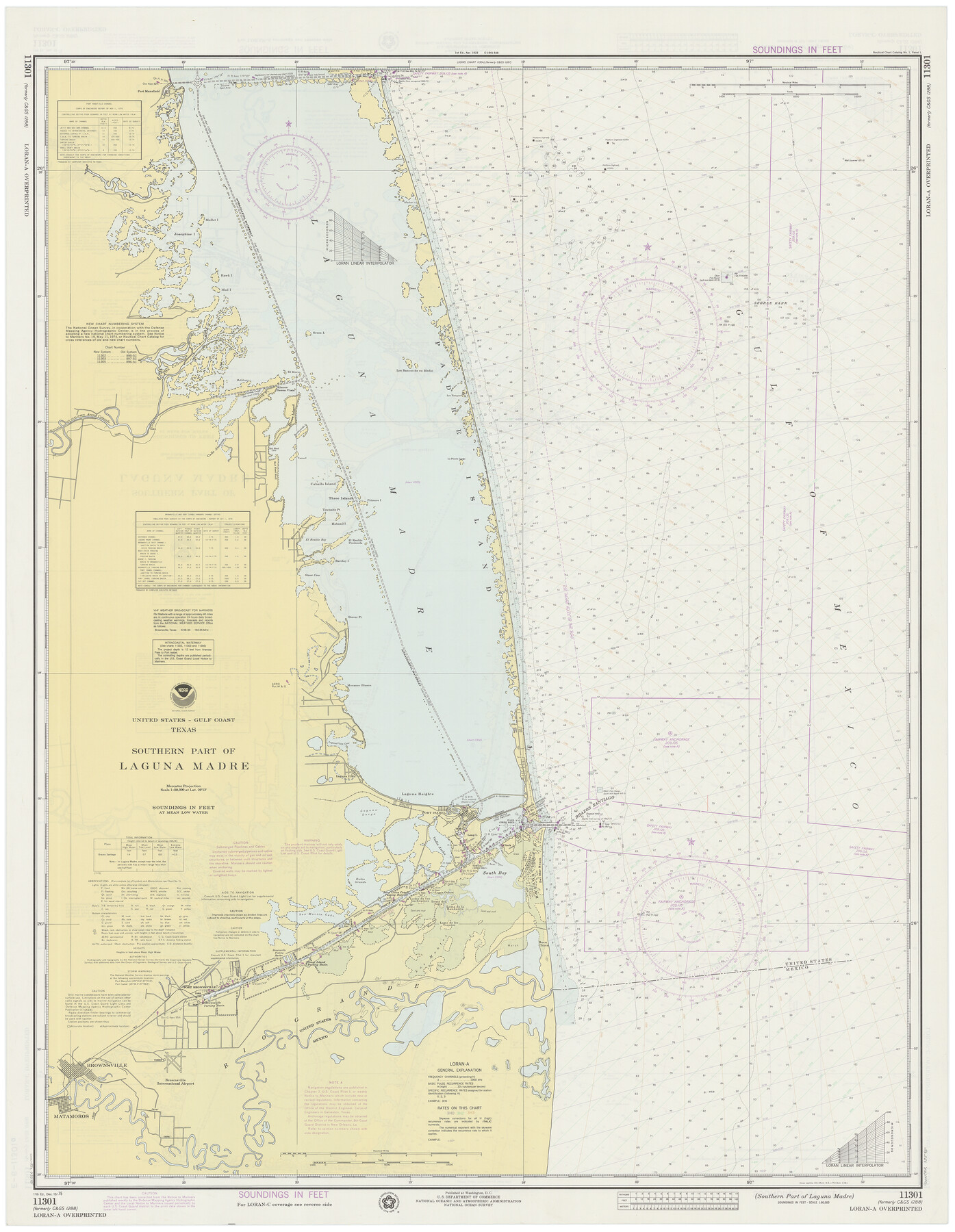
Southern Part of Laguna Madre
K-6-1288a
-
Map/Doc
73545
-
Collection
General Map Collection
-
Object Dates
12/13/1975 (Creation Date)
-
Counties
Willacy Cameron
-
Subjects
Nautical Charts
-
Height x Width
45.1 x 35.0 inches
114.6 x 88.9 cm
Part of: General Map Collection
Calhoun County NRC Article 33.136 Sketch 7

Print $63.00
- Digital $50.00
Calhoun County NRC Article 33.136 Sketch 7
2016
Size 17.1 x 21.8 inches
Map/Doc 94867
Hardin County Sketch File 1

Print $8.00
- Digital $50.00
Hardin County Sketch File 1
1851
Size 10.0 x 6.9 inches
Map/Doc 25079
Maps of Gulf Intracoastal Waterway, Texas - Sabine River to the Rio Grande and connecting waterways including ship channels

Print $20.00
- Digital $50.00
Maps of Gulf Intracoastal Waterway, Texas - Sabine River to the Rio Grande and connecting waterways including ship channels
1966
Size 14.5 x 22.4 inches
Map/Doc 61929
Map showing location of Texas Prison Farms surveyed for the Texas Prison System

Print $20.00
- Digital $50.00
Map showing location of Texas Prison Farms surveyed for the Texas Prison System
1934
Size 15.6 x 12.3 inches
Map/Doc 94277
Matagorda County Boundary File 1

Print $10.00
- Digital $50.00
Matagorda County Boundary File 1
Size 14.1 x 8.6 inches
Map/Doc 56884
Culberson County Rolled Sketch SL

Print $20.00
- Digital $50.00
Culberson County Rolled Sketch SL
1930
Size 19.1 x 24.7 inches
Map/Doc 5683
Sutton County Sketch File 61

Print $14.00
- Digital $50.00
Sutton County Sketch File 61
1986
Size 11.2 x 8.9 inches
Map/Doc 37557
Duval County Rolled Sketch 27

Print $40.00
- Digital $50.00
Duval County Rolled Sketch 27
Size 14.6 x 50.6 inches
Map/Doc 8814
Webb County Sketch File 7

Print $40.00
- Digital $50.00
Webb County Sketch File 7
1877
Size 13.7 x 14.3 inches
Map/Doc 39739

Montgomery County Working Sketch 25

Print $40.00
- Digital $50.00
Montgomery County Working Sketch 25
1941
Size 50.0 x 43.7 inches
Map/Doc 71132
Burnet County Sketch File 20

Print $4.00
- Digital $50.00
Burnet County Sketch File 20
1862
Size 10.1 x 8.0 inches
Map/Doc 16712
You may also like
Hidalgo County Working Sketch 6

Print $20.00
- Digital $50.00
Hidalgo County Working Sketch 6
1960
Size 21.4 x 20.4 inches
Map/Doc 66183
Morris County Rolled Sketch 2A

Print $20.00
- Digital $50.00
Morris County Rolled Sketch 2A
Size 36.5 x 20.0 inches
Map/Doc 10283
Frio County Rolled Sketch 26

Print $20.00
- Digital $50.00
Frio County Rolled Sketch 26
1994
Size 28.1 x 38.9 inches
Map/Doc 5926
Ochiltree County Boundary File 3

Print $10.00
- Digital $50.00
Ochiltree County Boundary File 3
Size 11.2 x 8.6 inches
Map/Doc 57677
Johnson County Working Sketch 23

Print $20.00
- Digital $50.00
Johnson County Working Sketch 23
1997
Size 25.3 x 22.8 inches
Map/Doc 66636
Carson County

Print $20.00
- Digital $50.00
Carson County
1932
Size 43.4 x 38.8 inches
Map/Doc 95449
Gaines County Rolled Sketch 15C

Print $40.00
- Digital $50.00
Gaines County Rolled Sketch 15C
Size 128.4 x 22.8 inches
Map/Doc 75928
Ellwood Farms Situated in Hockley, Lamb, and Hale Counties, Texas

Print $20.00
- Digital $50.00
Ellwood Farms Situated in Hockley, Lamb, and Hale Counties, Texas
Size 20.3 x 30.1 inches
Map/Doc 92229
Culberson County Rolled Sketch 69

Print $20.00
- Digital $50.00
Culberson County Rolled Sketch 69
Size 33.5 x 22.9 inches
Map/Doc 76425
Ed Gordon Irrigated Farm NE Quarter Section 14, Block E

Print $20.00
- Digital $50.00
Ed Gordon Irrigated Farm NE Quarter Section 14, Block E
1943
Size 16.0 x 18.6 inches
Map/Doc 92325
Montgomery County Working Sketch 49

Print $20.00
- Digital $50.00
Montgomery County Working Sketch 49
1959
Size 13.8 x 12.0 inches
Map/Doc 71156
Purchase Area Map, Ropesville Rural Communities, Hockley County, Texas

Print $40.00
- Digital $50.00
Purchase Area Map, Ropesville Rural Communities, Hockley County, Texas
1937
Size 52.9 x 29.3 inches
Map/Doc 89681