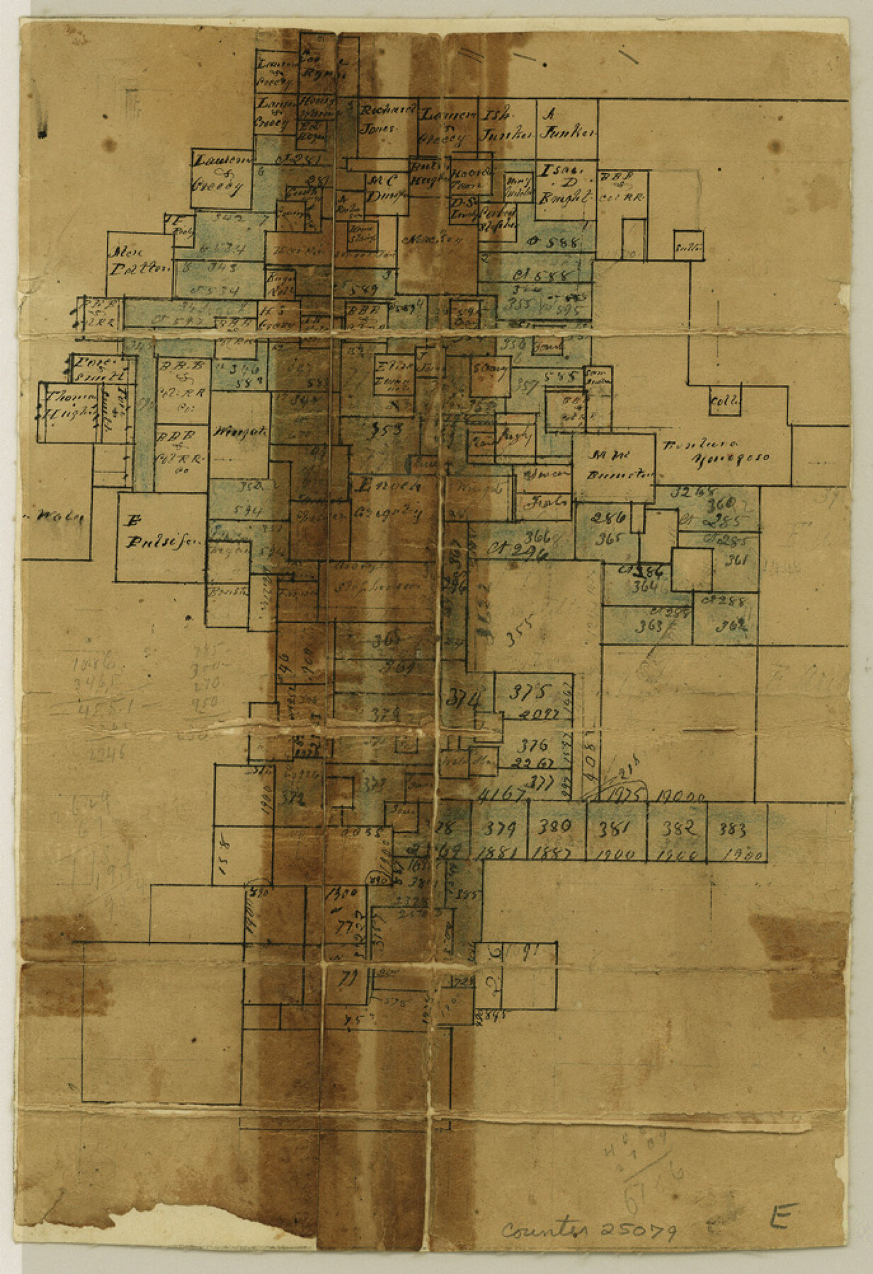
Hardin County Sketch File 1
[Sketch of surveys around the R. Sherman tract]
-
Map/Doc
25079
-
Collection
General Map Collection
-
Object Dates
1851/5/20 (Creation Date)
-
People and Organizations
H. Jackson (Surveyor/Engineer)
-
Counties
Hardin Polk Tyler
-
Subjects
Surveying Sketch File
-
Height x Width
10.0 x 6.9 inches
25.4 x 17.5 cm
-
Medium
paper, manuscript
Part of: General Map Collection
Gonzales County Working Sketch 13

Print $2.00
- Digital $50.00
Gonzales County Working Sketch 13
1981
Size 12.5 x 7.6 inches
Map/Doc 63229
Lamb County Working Sketch 4

Print $40.00
- Digital $50.00
Lamb County Working Sketch 4
1984
Size 42.9 x 58.0 inches
Map/Doc 70277
Coast Chart No. 210 - Aransas Pass and Corpus Christi Bay with the coast to latitude 27° 12', Texas

Print $20.00
- Digital $50.00
Coast Chart No. 210 - Aransas Pass and Corpus Christi Bay with the coast to latitude 27° 12', Texas
1887
Size 18.1 x 23.8 inches
Map/Doc 73446
Crockett County Rolled Sketch 79

Print $40.00
- Digital $50.00
Crockett County Rolled Sketch 79
1954
Size 37.3 x 48.3 inches
Map/Doc 8724
Dickens County Working Sketch 3

Print $20.00
- Digital $50.00
Dickens County Working Sketch 3
Size 17.5 x 15.3 inches
Map/Doc 68650
Menard County Working Sketch 18

Print $20.00
- Digital $50.00
Menard County Working Sketch 18
1946
Size 30.6 x 31.0 inches
Map/Doc 70965
Austin County Working Sketch 1

Print $20.00
- Digital $50.00
Austin County Working Sketch 1
1941
Size 27.7 x 30.1 inches
Map/Doc 67242
Williamson County

Print $40.00
- Digital $50.00
Williamson County
1888
Size 37.1 x 54.0 inches
Map/Doc 16930
Walker County Working Sketch 11

Print $20.00
- Digital $50.00
Walker County Working Sketch 11
1935
Size 28.2 x 38.8 inches
Map/Doc 72291

Anderson County Sketch File 5

Print $6.00
- Digital $50.00
Anderson County Sketch File 5
1856
Size 9.7 x 7.8 inches
Map/Doc 12750
[Map representing Townships 21, 20 and part of 19 of Range 17 and the corresponding ones in the 16th Range, according to the United States surveys showing the Boundary between the Republic of Texas and the United States of America]
![262, [Map representing Townships 21, 20 and part of 19 of Range 17 and the corresponding ones in the 16th Range, according to the United States surveys showing the Boundary between the Republic of Texas and the United States of America], General Map Collection](https://historictexasmaps.com/wmedia_w700/maps/262.tif.jpg)
Print $20.00
- Digital $50.00
[Map representing Townships 21, 20 and part of 19 of Range 17 and the corresponding ones in the 16th Range, according to the United States surveys showing the Boundary between the Republic of Texas and the United States of America]
1841
Size 19.5 x 15.4 inches
Map/Doc 262
You may also like
Flight Mission No. CRK-3P, Frame 63, Refugio County

Print $20.00
- Digital $50.00
Flight Mission No. CRK-3P, Frame 63, Refugio County
1956
Size 18.5 x 22.4 inches
Map/Doc 86905
Jackson County Working Sketch 2

Print $20.00
- Digital $50.00
Jackson County Working Sketch 2
1937
Size 41.5 x 38.0 inches
Map/Doc 66450
Oldham County Sketch File 18

Print $6.00
- Digital $50.00
Oldham County Sketch File 18
1910
Size 8.9 x 8.5 inches
Map/Doc 33272

Flight Mission No. DCL-4C, Frame 97, Kenedy County

Print $20.00
- Digital $50.00
Flight Mission No. DCL-4C, Frame 97, Kenedy County
1943
Size 18.6 x 22.4 inches
Map/Doc 85818
Flight Mission No. DAH-9M, Frame 156, Orange County

Print $20.00
- Digital $50.00
Flight Mission No. DAH-9M, Frame 156, Orange County
1953
Size 18.6 x 22.4 inches
Map/Doc 86855
Crockett County Rolled Sketch 46A

Print $40.00
- Digital $50.00
Crockett County Rolled Sketch 46A
Size 43.4 x 63.9 inches
Map/Doc 9199
Ward County Working Sketch 33

Print $20.00
- Digital $50.00
Ward County Working Sketch 33
1968
Size 26.3 x 32.3 inches
Map/Doc 72339


Flight Mission No. DIX-6P, Frame 185, Aransas County

Print $20.00
- Digital $50.00
Flight Mission No. DIX-6P, Frame 185, Aransas County
1956
Size 19.1 x 22.8 inches
Map/Doc 83847
Maps of Gulf Intracoastal Waterway, Texas - Sabine River to the Rio Grande and connecting waterways including ship channels

Print $20.00
- Digital $50.00
Maps of Gulf Intracoastal Waterway, Texas - Sabine River to the Rio Grande and connecting waterways including ship channels
1966
Size 14.6 x 22.2 inches
Map/Doc 61958