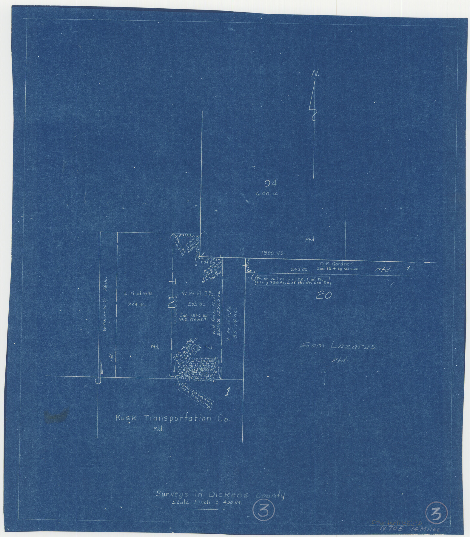
Dickens County Working Sketch 3
-
Map/Doc
68650
-
Collection
General Map Collection
-
Counties
Dickens
-
Subjects
Surveying Working Sketch
-
Height x Width
17.5 x 15.3 inches
44.5 x 38.9 cm
-
Scale
1" = 400 varas
Part of: General Map Collection
Flight Mission No. CGN-3P, Frame 53, San Patricio County

Print $20.00
- Digital $50.00
Flight Mission No. CGN-3P, Frame 53, San Patricio County
1956
Size 18.6 x 22.3 inches
Map/Doc 86983
Andrews County Working Sketch 11

Print $20.00
- Digital $50.00
Andrews County Working Sketch 11
1955
Size 20.6 x 25.2 inches
Map/Doc 67057
Sketch of surveys in Harrison & Marion Cos. Showing Caddo Lake & Subdivisions

Print $20.00
- Digital $50.00
Sketch of surveys in Harrison & Marion Cos. Showing Caddo Lake & Subdivisions
1955
Size 33.8 x 32.4 inches
Map/Doc 93284
Flight Mission No. DAG-24K, Frame 38, Matagorda County

Print $20.00
- Digital $50.00
Flight Mission No. DAG-24K, Frame 38, Matagorda County
1953
Size 18.5 x 15.8 inches
Map/Doc 86525
Map of Asia (Inset: Palestine)

Print $20.00
- Digital $50.00
Map of Asia (Inset: Palestine)
1844
Size 12.1 x 19.0 inches
Map/Doc 93548
Outer Continental Shelf Leasing Maps (Louisiana Offshore Operations)

Print $20.00
- Digital $50.00
Outer Continental Shelf Leasing Maps (Louisiana Offshore Operations)
1955
Size 8.8 x 10.0 inches
Map/Doc 76091
Terrell County Working Sketch 85

Print $20.00
- Digital $50.00
Terrell County Working Sketch 85
1994
Size 31.3 x 42.8 inches
Map/Doc 69609
Controlled Mosaic by Jack Amman Photogrammetric Engineers, Inc - Sheet 41

Print $20.00
- Digital $50.00
Controlled Mosaic by Jack Amman Photogrammetric Engineers, Inc - Sheet 41
1954
Size 20.0 x 24.0 inches
Map/Doc 83498
Chambers County Rolled Sketch 20

Print $1171.00
- Digital $50.00
Chambers County Rolled Sketch 20
Size 10.7 x 16.2 inches
Map/Doc 43987
Culberson County Sketch File 3

Print $58.00
- Digital $50.00
Culberson County Sketch File 3
Size 8.0 x 3.3 inches
Map/Doc 20112
Flight Mission No. BQR-12K, Frame 46, Brazoria County

Print $20.00
- Digital $50.00
Flight Mission No. BQR-12K, Frame 46, Brazoria County
1952
Size 18.8 x 22.4 inches
Map/Doc 84061
Kleberg County Rolled Sketch 10-25

Print $20.00
- Digital $50.00
Kleberg County Rolled Sketch 10-25
1952
Size 38.1 x 35.8 inches
Map/Doc 9365
You may also like
Bexar County State Real Property Sketch 4

Print $20.00
- Digital $50.00
Bexar County State Real Property Sketch 4
2013
Size 25.0 x 36.5 inches
Map/Doc 93692
The Mexican Municipality of Harrisburg. Defined, January 4, 1836

Print $20.00
The Mexican Municipality of Harrisburg. Defined, January 4, 1836
2020
Size 18.4 x 21.7 inches
Map/Doc 96022
Upton County Sketch File D

Print $12.00
- Digital $50.00
Upton County Sketch File D
Size 13.6 x 9.0 inches
Map/Doc 38854
Railroad Track Map, H&TCRRCo., Falls County, Texas

Print $4.00
- Digital $50.00
Railroad Track Map, H&TCRRCo., Falls County, Texas
1918
Size 11.7 x 18.5 inches
Map/Doc 62831
Nolan County Working Sketch 4

Print $20.00
- Digital $50.00
Nolan County Working Sketch 4
1948
Size 21.6 x 28.9 inches
Map/Doc 71295
Dallas County Working Sketch 10

Print $20.00
- Digital $50.00
Dallas County Working Sketch 10
1971
Size 22.6 x 22.7 inches
Map/Doc 68576
Eastland County Working Sketch 21

Print $20.00
- Digital $50.00
Eastland County Working Sketch 21
1920
Size 15.4 x 22.7 inches
Map/Doc 68802
Map of the Missouri, Kansas, & Texas Railway and Connecting Lines

Print $20.00
- Digital $50.00
Map of the Missouri, Kansas, & Texas Railway and Connecting Lines
Size 11.2 x 17.2 inches
Map/Doc 96599
Plat of a survey of the North part of section 16, Block 362, Martha McBride, Presidio County, Texas

Print $20.00
- Digital $50.00
Plat of a survey of the North part of section 16, Block 362, Martha McBride, Presidio County, Texas
1989
Size 24.3 x 36.1 inches
Map/Doc 60523
Stonewall County Rolled Sketch 27

Print $20.00
- Digital $50.00
Stonewall County Rolled Sketch 27
Size 31.0 x 44.2 inches
Map/Doc 9966
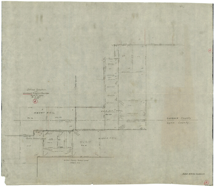
Lubbock County Working Sketch 4
Print $20.00
- Digital $50.00
Lubbock County Working Sketch 4
1947
Size 31.8 x 36.8 inches
Map/Doc 70664
Flight Mission No. DAG-14K, Frame 42, Matagorda County

Print $20.00
- Digital $50.00
Flight Mission No. DAG-14K, Frame 42, Matagorda County
1952
Size 18.5 x 22.3 inches
Map/Doc 86300