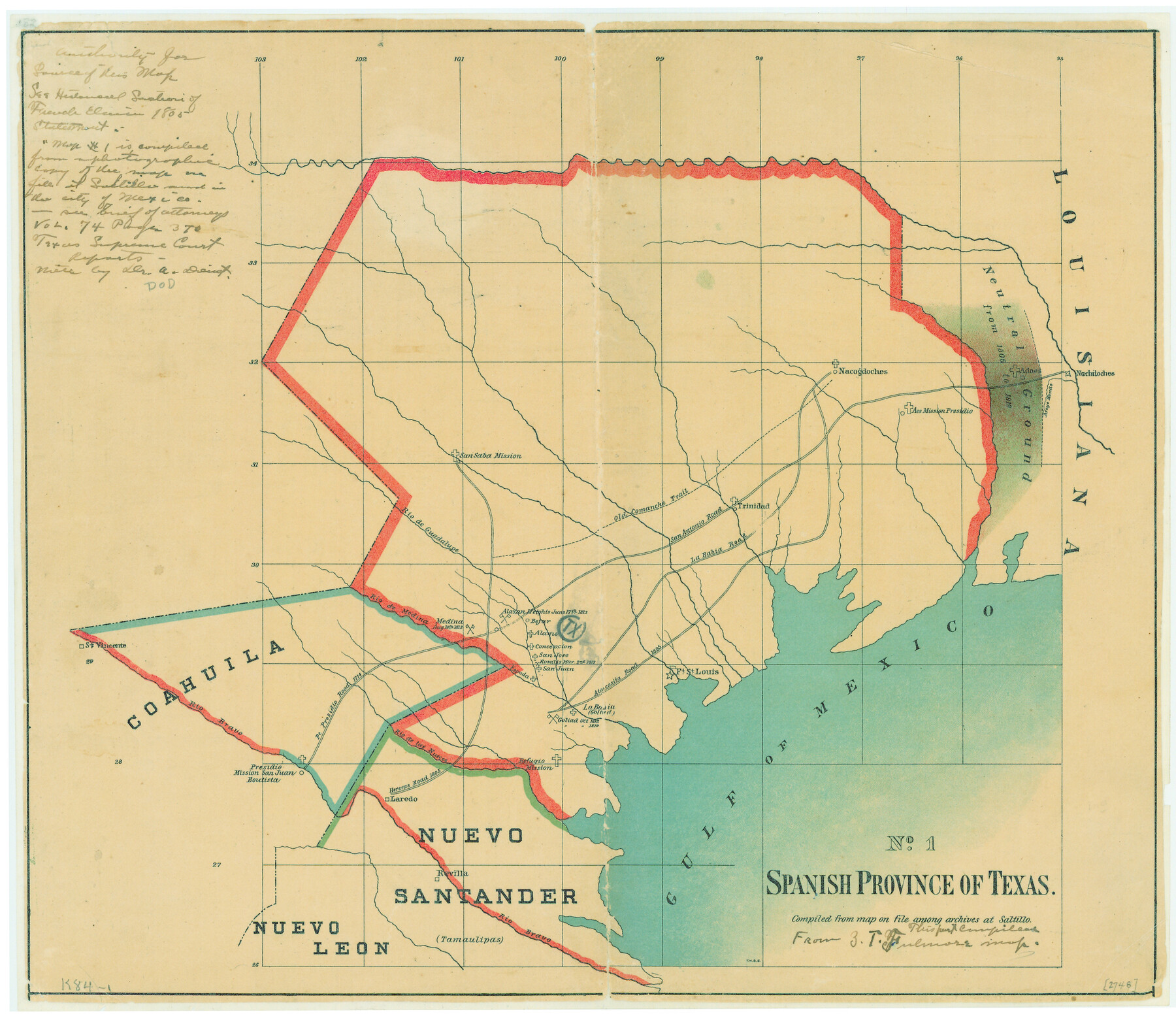
Spanish Province of Texas Compiled from map on file among archives at Saltillo
-
Map/Doc
79742
-
Collection
Texas State Library and Archives
-
People and Organizations
Compiled from the archives at Saltillo, Mexico (Publisher)
-
Subjects
Spanish Texas
-
Height x Width
13.8 x 16.2 inches
35.1 x 41.2 cm
-
Comments
Prints available courtesy of the Texas State Library and Archives.
More info can be found here: TSLAC Map 02748
Part of: Texas State Library and Archives
General Highway Map, Jeff Davis County, Texas

Print $20.00
General Highway Map, Jeff Davis County, Texas
1940
Size 18.6 x 24.8 inches
Map/Doc 79143
General Highway Map, Parker County, Texas

Print $20.00
General Highway Map, Parker County, Texas
1961
Size 18.3 x 24.5 inches
Map/Doc 79625
General Highway Map, Lamb County, Texas

Print $20.00
General Highway Map, Lamb County, Texas
1961
Size 24.5 x 18.2 inches
Map/Doc 79562
General Highway Map. Detail of Cities and Towns in Nacogdoches County, Texas

Print $20.00
General Highway Map. Detail of Cities and Towns in Nacogdoches County, Texas
1961
Size 19.3 x 25.0 inches
Map/Doc 79608
General Highway Map, Kerr County, Texas

Print $20.00
General Highway Map, Kerr County, Texas
1961
Size 24.8 x 18.2 inches
Map/Doc 79551
General Highway Map, Jim Wells County, Texas

Print $20.00
General Highway Map, Jim Wells County, Texas
1940
Size 18.4 x 24.8 inches
Map/Doc 79147
General Highway Map, Hutchinson County, Texas

Print $20.00
General Highway Map, Hutchinson County, Texas
1940
Size 18.3 x 24.8 inches
Map/Doc 79137
General Highway Map. Detail of Cities and Towns in Harris County, Texas. City Map [of] Houston, Pasadena, West University Place, Bellaire, Galena Park, Jacinto City, South Houston, South Side Place, Deer Park, and vicinity, Harris County, Texas
![79506, General Highway Map. Detail of Cities and Towns in Harris County, Texas. City Map [of] Houston, Pasadena, West University Place, Bellaire, Galena Park, Jacinto City, South Houston, South Side Place, Deer Park, and vicinity, Harris County, Texas, Texas State Library and Archives](https://historictexasmaps.com/wmedia_w700/maps/79506.tif.jpg)
Print $20.00
General Highway Map. Detail of Cities and Towns in Harris County, Texas. City Map [of] Houston, Pasadena, West University Place, Bellaire, Galena Park, Jacinto City, South Houston, South Side Place, Deer Park, and vicinity, Harris County, Texas
1961
Size 18.0 x 24.9 inches
Map/Doc 79506
General Highway Map, Menard County, Texas

Print $20.00
General Highway Map, Menard County, Texas
1940
Size 18.5 x 24.8 inches
Map/Doc 79196
General Highway Map, Colorado County, Texas

Print $20.00
General Highway Map, Colorado County, Texas
1961
Size 25.1 x 18.3 inches
Map/Doc 79416
General Highway Map, Nolan County, Texas

Print $20.00
General Highway Map, Nolan County, Texas
1961
Size 19.3 x 25.0 inches
Map/Doc 79614
General Highway Map. Detail of Cities and Towns in Tarrant County, Texas [Fort Worth and vicinity]
![79253, General Highway Map. Detail of Cities and Towns in Tarrant County, Texas [Fort Worth and vicinity], Texas State Library and Archives](https://historictexasmaps.com/wmedia_w700/maps/79253-GC.tif.jpg)
Print $20.00
General Highway Map. Detail of Cities and Towns in Tarrant County, Texas [Fort Worth and vicinity]
1940
Size 24.8 x 18.4 inches
Map/Doc 79253
You may also like
Presidio County Working Sketch 12

Print $20.00
- Digital $50.00
Presidio County Working Sketch 12
1941
Size 22.3 x 19.9 inches
Map/Doc 71687
Flight Mission No. BRA-7M, Frame 141, Jefferson County

Print $20.00
- Digital $50.00
Flight Mission No. BRA-7M, Frame 141, Jefferson County
1953
Size 18.6 x 22.4 inches
Map/Doc 85535
Duval County Boundary File 1d

Print $40.00
- Digital $50.00
Duval County Boundary File 1d
Size 6.6 x 47.7 inches
Map/Doc 52699
Blanco County Sketch File 32

Print $4.00
- Digital $50.00
Blanco County Sketch File 32
1888
Size 8.5 x 11.1 inches
Map/Doc 14633
Brewster County Rolled Sketch 125

Print $179.00
- Digital $50.00
Brewster County Rolled Sketch 125
1889
Map/Doc 43141
Map of Jones County, Texas

Print $20.00
Map of Jones County, Texas
1879
Size 24.7 x 18.8 inches
Map/Doc 88960
Glasscock County Working Sketch 10

Print $40.00
- Digital $50.00
Glasscock County Working Sketch 10
1957
Size 77.9 x 37.2 inches
Map/Doc 63183
Presidio County Working Sketch 38

Print $20.00
- Digital $50.00
Presidio County Working Sketch 38
1948
Size 35.0 x 22.2 inches
Map/Doc 71715
South Part Presidio County

Print $20.00
- Digital $50.00
South Part Presidio County
1975
Size 35.0 x 40.3 inches
Map/Doc 95617
Hood County Rolled Sketch 3

Print $20.00
- Digital $50.00
Hood County Rolled Sketch 3
1967
Size 33.2 x 36.2 inches
Map/Doc 9179
Dallas County Boundary File 7 and 7a and 7b

Print $8.00
- Digital $50.00
Dallas County Boundary File 7 and 7a and 7b
Size 11.2 x 8.6 inches
Map/Doc 52291
Wilbarger County Boundary File 1b

Print $40.00
- Digital $50.00
Wilbarger County Boundary File 1b
Size 14.3 x 8.8 inches
Map/Doc 59943