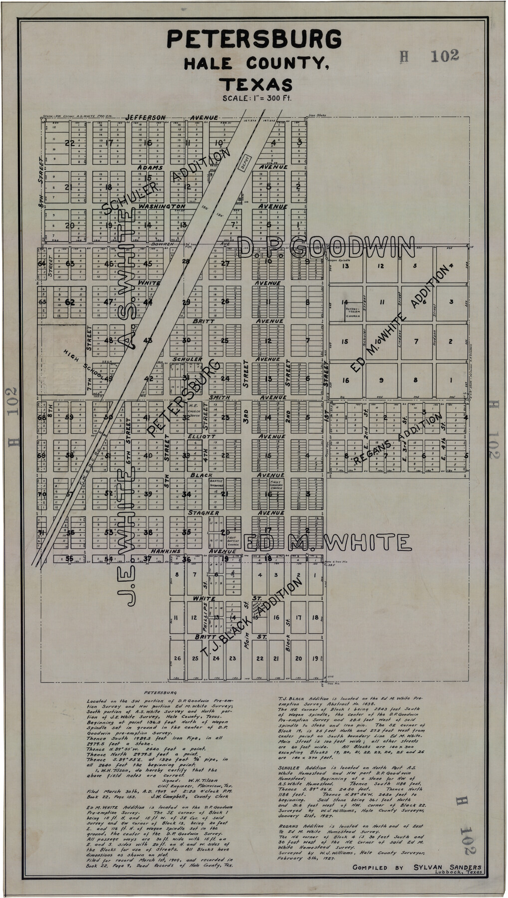
Petersburg, Hale County, Texas
H102
-
Map/Doc
92699
-
Collection
Twichell Survey Records
-
Object Dates
1927 (Creation Date)
-
People and Organizations
Sylvan Sanders (Compiler)
-
Counties
Hale
-
Height x Width
16.1 x 28.4 inches
40.9 x 72.1 cm
Part of: Twichell Survey Records
Northeastern Half of Pecos County - Ownership Map

Print $40.00
- Digital $50.00
Northeastern Half of Pecos County - Ownership Map
Size 92.7 x 37.2 inches
Map/Doc 93197
Brazos River Conservation and Reclamation District Official Boundary Line Survey

Print $20.00
- Digital $50.00
Brazos River Conservation and Reclamation District Official Boundary Line Survey
Size 37.0 x 25.0 inches
Map/Doc 90130
[Sketch of part of county with G.H. & S.A. Blk. 3 on North, H. & T.C. Blk. 4 on West, T. & P. Blk. 1 on South, T. & S. Blks. 224 & 301 on East]
![89958, [Sketch of part of county with G.H. & S.A. Blk. 3 on North, H. & T.C. Blk. 4 on West, T. & P. Blk. 1 on South, T. & S. Blks. 224 & 301 on East], Twichell Survey Records](https://historictexasmaps.com/wmedia_w700/maps/89958-1.tif.jpg)
Print $40.00
- Digital $50.00
[Sketch of part of county with G.H. & S.A. Blk. 3 on North, H. & T.C. Blk. 4 on West, T. & P. Blk. 1 on South, T. & S. Blks. 224 & 301 on East]
Size 51.9 x 37.9 inches
Map/Doc 89958
Re-Subdivision of a Part of E. Dick Slaughter Lands Cochran County, Texas

Print $20.00
- Digital $50.00
Re-Subdivision of a Part of E. Dick Slaughter Lands Cochran County, Texas
Size 31.0 x 21.9 inches
Map/Doc 92482
Lands of C. W. Post in Garza and Lynn Counties, Texas, and Surrounding Lands

Print $20.00
- Digital $50.00
Lands of C. W. Post in Garza and Lynn Counties, Texas, and Surrounding Lands
Size 15.8 x 18.0 inches
Map/Doc 92645
A true copy of Peck's field book pages 56 to 63 except classification of lands

Print $40.00
- Digital $50.00
A true copy of Peck's field book pages 56 to 63 except classification of lands
Size 6.3 x 69.2 inches
Map/Doc 89716
[Block S, Sections 4 and 11]
![92834, [Block S, Sections 4 and 11], Twichell Survey Records](https://historictexasmaps.com/wmedia_w700/maps/92834-1.tif.jpg)
Print $20.00
- Digital $50.00
[Block S, Sections 4 and 11]
1951
Size 14.8 x 12.2 inches
Map/Doc 92834
[Subdivision of Crockett County School Land Lgs. 214-217]
![90106, [Subdivision of Crockett County School Land Lgs. 214-217], Twichell Survey Records](https://historictexasmaps.com/wmedia_w700/maps/90106-1.tif.jpg)
Print $2.00
- Digital $50.00
[Subdivision of Crockett County School Land Lgs. 214-217]
Size 12.4 x 8.5 inches
Map/Doc 90106
Exhibit E, Robert Violette M. A. 34719, Gaines County, Texas

Print $40.00
- Digital $50.00
Exhibit E, Robert Violette M. A. 34719, Gaines County, Texas
Size 85.9 x 24.3 inches
Map/Doc 93134
Part of a map showing resurvey of Capitol Leagues by R. S. Hunnicutt & Behn Cook State Surveyors

Print $20.00
- Digital $50.00
Part of a map showing resurvey of Capitol Leagues by R. S. Hunnicutt & Behn Cook State Surveyors
Size 21.6 x 17.3 inches
Map/Doc 90277
Map Showing Block HG and Connecting Surveys

Print $2.00
- Digital $50.00
Map Showing Block HG and Connecting Surveys
1907
Size 9.2 x 13.7 inches
Map/Doc 90681
Working Sketch in Hutchinson County

Print $2.00
- Digital $50.00
Working Sketch in Hutchinson County
1898
Size 8.7 x 15.4 inches
Map/Doc 92975
You may also like
Map of Chambers County, Texas

Print $20.00
- Digital $50.00
Map of Chambers County, Texas
1879
Size 26.3 x 30.7 inches
Map/Doc 695
Jackson County Rolled Sketch 6

Print $20.00
- Digital $50.00
Jackson County Rolled Sketch 6
1914
Size 23.6 x 26.6 inches
Map/Doc 6341
Right of Way and Track Map, the Missouri, Kansas & Texas Ry. Of Texas operated by the Missouri, Kansas & Texas Ry. Of Texas, Houston Division

Print $40.00
- Digital $50.00
Right of Way and Track Map, the Missouri, Kansas & Texas Ry. Of Texas operated by the Missouri, Kansas & Texas Ry. Of Texas, Houston Division
1918
Size 25.6 x 64.4 inches
Map/Doc 64566
[Sketch Between Collingsworth County and Oklahoma]
![89663, [Sketch Between Collingsworth County and Oklahoma], Twichell Survey Records](https://historictexasmaps.com/wmedia_w700/maps/89663-1.tif.jpg)
Print $40.00
- Digital $50.00
[Sketch Between Collingsworth County and Oklahoma]
Size 9.4 x 62.5 inches
Map/Doc 89663
Refugio County Boundary File 3a

Print $28.00
- Digital $50.00
Refugio County Boundary File 3a
Size 14.1 x 8.8 inches
Map/Doc 58246
Liberty County Working Sketch 7

Print $20.00
- Digital $50.00
Liberty County Working Sketch 7
1906
Size 22.2 x 24.8 inches
Map/Doc 70466
New Map of the State of Texas compiled from the latest authorities

Print $20.00
New Map of the State of Texas compiled from the latest authorities
1877
Size 19.1 x 21.4 inches
Map/Doc 79300
Pecos County Rolled Sketch 36

Print $20.00
- Digital $50.00
Pecos County Rolled Sketch 36
1906
Size 32.0 x 23.4 inches
Map/Doc 7216
Matagorda County Boundary File 101

Print $10.00
- Digital $50.00
Matagorda County Boundary File 101
Size 8.9 x 7.4 inches
Map/Doc 56896
General Highway Map. Detail of Cities and Towns in Dallas County, Texas [Dallas and vicinity]
![79068, General Highway Map. Detail of Cities and Towns in Dallas County, Texas [Dallas and vicinity], Texas State Library and Archives](https://historictexasmaps.com/wmedia_w700/maps/79068.tif.jpg)
Print $20.00
General Highway Map. Detail of Cities and Towns in Dallas County, Texas [Dallas and vicinity]
1936
Size 18.5 x 25.2 inches
Map/Doc 79068
Jasper County Sketch File 18

Print $32.00
- Digital $50.00
Jasper County Sketch File 18
1890
Size 12.6 x 7.9 inches
Map/Doc 27808
Jefferson County Rolled Sketch 60

Print $20.00
- Digital $50.00
Jefferson County Rolled Sketch 60
1885
Size 31.0 x 35.6 inches
Map/Doc 9315