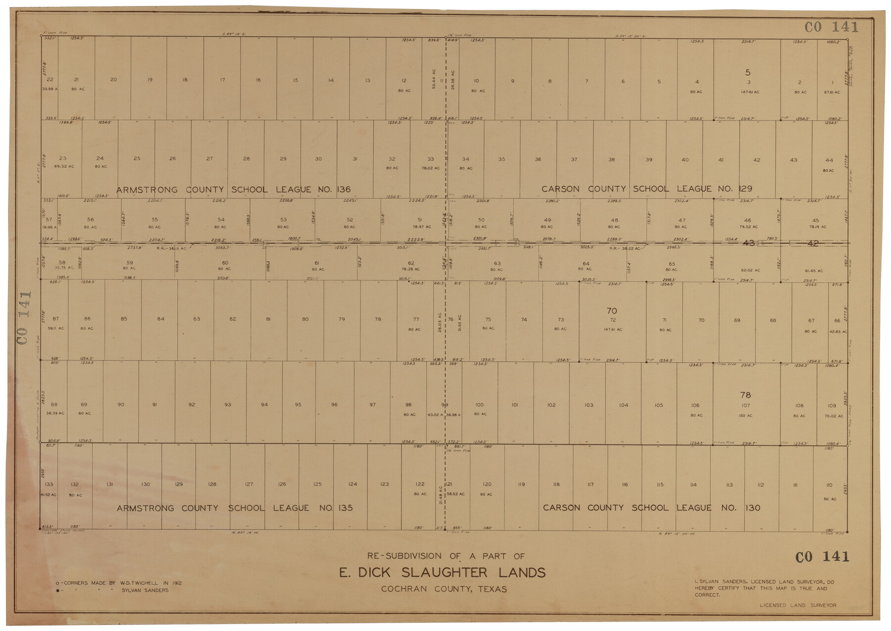
Re-Subdivision of a Part of E. Dick Slaughter Lands Cochran County, Texas
CO141
-
Map/Doc
92482
-
Collection
Twichell Survey Records
-
People and Organizations
Sylvan Sanders (Surveyor/Engineer)
-
Counties
Cochran
-
Height x Width
31.0 x 21.9 inches
78.7 x 55.6 cm
Part of: Twichell Survey Records
Terry County Memorial Cemetery

Print $20.00
- Digital $50.00
Terry County Memorial Cemetery
Size 35.3 x 14.4 inches
Map/Doc 92931
[Area along North line of McLennan County School Land]
![90928, [Area along North line of McLennan County School Land], Twichell Survey Records](https://historictexasmaps.com/wmedia_w700/maps/90928-1.tif.jpg)
Print $2.00
- Digital $50.00
[Area along North line of McLennan County School Land]
1920
Size 5.5 x 14.9 inches
Map/Doc 90928
[Mrs. May Vinson Survey]
![91943, [Mrs. May Vinson Survey], Twichell Survey Records](https://historictexasmaps.com/wmedia_w700/maps/91943-1.tif.jpg)
Print $20.00
- Digital $50.00
[Mrs. May Vinson Survey]
Size 25.0 x 14.6 inches
Map/Doc 91943
Map of Spearman Lands

Print $20.00
- Digital $50.00
Map of Spearman Lands
Size 20.1 x 15.3 inches
Map/Doc 90791
Canyon City,Texas, County Seat of Randall County

Print $20.00
- Digital $50.00
Canyon City,Texas, County Seat of Randall County
Size 20.3 x 25.1 inches
Map/Doc 92152
[H. & T. C. Block 47, Sections 58-66 and part of Block 3]
![91791, [H. & T. C. Block 47, Sections 58-66 and part of Block 3], Twichell Survey Records](https://historictexasmaps.com/wmedia_w700/maps/91791-1.tif.jpg)
Print $20.00
- Digital $50.00
[H. & T. C. Block 47, Sections 58-66 and part of Block 3]
Size 24.1 x 12.7 inches
Map/Doc 91791
Ownership Map Hockley County, Texas

Print $20.00
- Digital $50.00
Ownership Map Hockley County, Texas
Size 19.1 x 20.4 inches
Map/Doc 92208
Working Sketch in Hutchinson County

Print $20.00
- Digital $50.00
Working Sketch in Hutchinson County
1922
Size 16.9 x 13.6 inches
Map/Doc 91251
[Blocks 3, Q, and Vicinity]
![91276, [Blocks 3, Q, and Vicinity], Twichell Survey Records](https://historictexasmaps.com/wmedia_w700/maps/91276.tif.jpg)
Print $20.00
- Digital $50.00
[Blocks 3, Q, and Vicinity]
Size 19.1 x 9.2 inches
Map/Doc 91276
[Columbus Tap RR. Co. Block 1-A, B. S. & F. Block 1, T. & N. O. Block 7T and vicinity]
![90577, [Columbus Tap RR. Co. Block 1-A, B. S. & F. Block 1, T. & N. O. Block 7T and vicinity], Twichell Survey Records](https://historictexasmaps.com/wmedia_w700/maps/90577-1.tif.jpg)
Print $2.00
- Digital $50.00
[Columbus Tap RR. Co. Block 1-A, B. S. & F. Block 1, T. & N. O. Block 7T and vicinity]
Size 6.1 x 9.6 inches
Map/Doc 90577
[R. T. Bucy's Survey 3, League 321]
![91348, [R. T. Bucy's Survey 3, League 321], Twichell Survey Records](https://historictexasmaps.com/wmedia_w700/maps/91348.tif.jpg)
Digital $50.00
[R. T. Bucy's Survey 3, League 321]
Map/Doc 91348
[Townships 1 & 2, Blocks 53, 54, 55, and 76]
![92882, [Townships 1 & 2, Blocks 53, 54, 55, and 76], Twichell Survey Records](https://historictexasmaps.com/wmedia_w700/maps/92882-1.tif.jpg)
Print $20.00
- Digital $50.00
[Townships 1 & 2, Blocks 53, 54, 55, and 76]
Size 29.3 x 24.0 inches
Map/Doc 92882
You may also like
[Sketch showing North line of James Stewart survey and vicinity]
![90116, [Sketch showing North line of James Stewart survey and vicinity], Twichell Survey Records](https://historictexasmaps.com/wmedia_w700/maps/90116-1.tif.jpg)
Print $20.00
- Digital $50.00
[Sketch showing North line of James Stewart survey and vicinity]
Size 30.0 x 9.0 inches
Map/Doc 90116
[Sketch for Mineral Application 14125 - Neches River, R. B. Moore]
![65667, [Sketch for Mineral Application 14125 - Neches River, R. B. Moore], General Map Collection](https://historictexasmaps.com/wmedia_w700/maps/65667.tif.jpg)
Print $40.00
- Digital $50.00
[Sketch for Mineral Application 14125 - Neches River, R. B. Moore]
1928
Size 26.1 x 50.0 inches
Map/Doc 65667
[J. B. Sneed, S. Robinson, and vicinity]
![91041, [J. B. Sneed, S. Robinson, and vicinity], Twichell Survey Records](https://historictexasmaps.com/wmedia_w700/maps/91041-1.tif.jpg)
Print $20.00
- Digital $50.00
[J. B. Sneed, S. Robinson, and vicinity]
Size 32.4 x 12.8 inches
Map/Doc 91041
Wise County Sketch File 34

Print $6.00
- Digital $50.00
Wise County Sketch File 34
1856
Size 6.3 x 9.6 inches
Map/Doc 40592
Water-Shed of the Brazos River

Print $40.00
- Digital $50.00
Water-Shed of the Brazos River
1925
Size 35.0 x 88.0 inches
Map/Doc 65263
United States - Gulf Coast - Galveston to Rio Grande

Print $20.00
- Digital $50.00
United States - Gulf Coast - Galveston to Rio Grande
Size 27.9 x 18.3 inches
Map/Doc 72742
Flight Mission No. BQR-9K, Frame 10, Brazoria County

Print $20.00
- Digital $50.00
Flight Mission No. BQR-9K, Frame 10, Brazoria County
1952
Size 18.7 x 22.3 inches
Map/Doc 84039
Lampasas County Working Sketch 10

Print $20.00
- Digital $50.00
Lampasas County Working Sketch 10
1963
Size 32.2 x 42.9 inches
Map/Doc 70287
Flight Mission No. DQO-3K, Frame 19, Galveston County

Print $20.00
- Digital $50.00
Flight Mission No. DQO-3K, Frame 19, Galveston County
1952
Size 18.7 x 22.5 inches
Map/Doc 85060
Jack County Sketch File 15

Print $4.00
- Digital $50.00
Jack County Sketch File 15
1880
Size 7.3 x 13.7 inches
Map/Doc 27545
Nueces County Rolled Sketch 101

Print $88.00
Nueces County Rolled Sketch 101
1985
Size 18.2 x 24.6 inches
Map/Doc 7061
Duval County Working Sketch 16

Print $20.00
- Digital $50.00
Duval County Working Sketch 16
1939
Size 14.6 x 25.3 inches
Map/Doc 68729