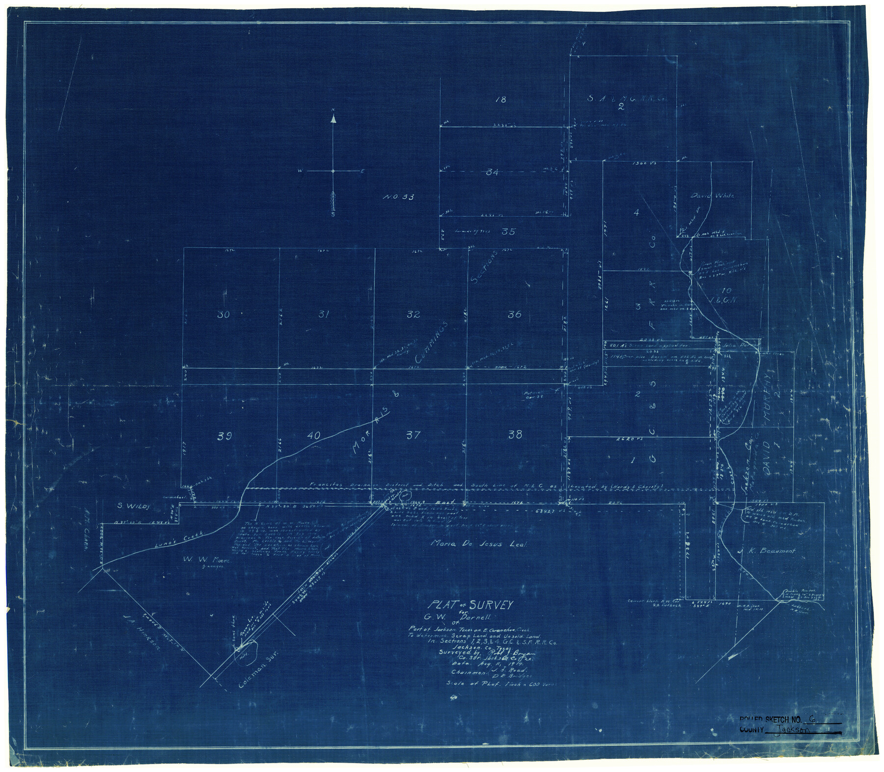
Jackson County Rolled Sketch 6
Plat of survey for G.W. Darnell of part of Jackson, Texas on E. Caranchua Creek to determine scrap land and unsold land in sections 1, 2, 3, & 4 G. C. & S. F. R.R. Co.
-
Map/Doc
6341
-
Collection
General Map Collection
-
Object Dates
8/11/1914 (Creation Date)
-
People and Organizations
Robt. J. Bryan (Surveyor/Engineer)
J.A. Reed (Chainman/Field Personnel)
D.E. Bridges (Chainman/Field Personnel)
-
Counties
Jackson
-
Subjects
Surveying Rolled Sketch
-
Height x Width
23.6 x 26.6 inches
59.9 x 67.6 cm
-
Medium
blueprint/diazo
-
Scale
1" = 600 varas
Part of: General Map Collection
Aransas County Working Sketch 2

Print $3.00
- Digital $50.00
Aransas County Working Sketch 2
1926
Size 16.3 x 9.7 inches
Map/Doc 67169
Presidio County Rolled Sketch 83B

Print $20.00
- Digital $50.00
Presidio County Rolled Sketch 83B
Size 16.6 x 23.0 inches
Map/Doc 2061
[Surveys in the Jasper District]
![69734, [Surveys in the Jasper District], General Map Collection](https://historictexasmaps.com/wmedia_w700/maps/69734.tif.jpg)
Print $2.00
- Digital $50.00
[Surveys in the Jasper District]
1847
Size 9.4 x 6.9 inches
Map/Doc 69734
Flight Mission No. DCL-4C, Frame 69, Kenedy County

Print $20.00
- Digital $50.00
Flight Mission No. DCL-4C, Frame 69, Kenedy County
1943
Size 18.7 x 22.3 inches
Map/Doc 85814
Kenedy County Aerial Photograph Index Sheet 6

Print $20.00
- Digital $50.00
Kenedy County Aerial Photograph Index Sheet 6
1943
Size 23.4 x 18.4 inches
Map/Doc 83716
Flight Mission No. DAG-19K, Frame 58, Matagorda County

Print $20.00
- Digital $50.00
Flight Mission No. DAG-19K, Frame 58, Matagorda County
1952
Size 18.5 x 16.3 inches
Map/Doc 86385
Maverick County Rolled Sketch 20

Print $20.00
- Digital $50.00
Maverick County Rolled Sketch 20
Size 24.5 x 38.7 inches
Map/Doc 6712
Pecos County Working Sketch 117

Print $40.00
- Digital $50.00
Pecos County Working Sketch 117
1973
Size 57.7 x 36.8 inches
Map/Doc 71590
Rusk County Working Sketch 17

Print $20.00
- Digital $50.00
Rusk County Working Sketch 17
1955
Size 25.1 x 32.9 inches
Map/Doc 63652
Wichita County Boundary File 2

Print $30.00
- Digital $50.00
Wichita County Boundary File 2
Size 9.1 x 4.7 inches
Map/Doc 59900
Concho County Sketch File 8

Print $44.00
- Digital $50.00
Concho County Sketch File 8
1886
Size 16.2 x 12.2 inches
Map/Doc 19131
Flight Mission No. CRC-4R, Frame 108, Chambers County

Print $20.00
- Digital $50.00
Flight Mission No. CRC-4R, Frame 108, Chambers County
1956
Size 18.7 x 22.4 inches
Map/Doc 84905
You may also like
Outer Continental Shelf Leasing Maps (Louisiana Offshore Operations)

Print $20.00
- Digital $50.00
Outer Continental Shelf Leasing Maps (Louisiana Offshore Operations)
1959
Size 18.1 x 14.3 inches
Map/Doc 76110
Coleman County Sketch File 34

Print $28.00
- Digital $50.00
Coleman County Sketch File 34
1878
Size 12.8 x 8.1 inches
Map/Doc 18726
Houston County Sketch File 41

Print $6.00
- Digital $50.00
Houston County Sketch File 41
1845
Size 16.0 x 10.2 inches
Map/Doc 26828
Hartley County

Print $40.00
- Digital $50.00
Hartley County
1925
Size 41.9 x 52.1 inches
Map/Doc 1851
Flight Mission No. DAG-17K, Frame 140, Matagorda County

Print $20.00
- Digital $50.00
Flight Mission No. DAG-17K, Frame 140, Matagorda County
1952
Size 16.5 x 16.1 inches
Map/Doc 86357
Archer County Sketch File 4

Print $4.00
- Digital $50.00
Archer County Sketch File 4
1855
Size 12.2 x 8.2 inches
Map/Doc 13630
Flight Mission No. DIX-5P, Frame 149, Aransas County

Print $20.00
- Digital $50.00
Flight Mission No. DIX-5P, Frame 149, Aransas County
1956
Size 17.8 x 17.8 inches
Map/Doc 83811
Lipscomb County Boundary File 14a

Print $4.00
- Digital $50.00
Lipscomb County Boundary File 14a
Size 11.3 x 8.7 inches
Map/Doc 56368
[Beaty and Moulton Block A, Southern Pacific Railroad Block 2]
![91398, [Beaty and Moulton Block A, Southern Pacific Railroad Block 2], Twichell Survey Records](https://historictexasmaps.com/wmedia_w700/maps/91398-1.tif.jpg)
Print $20.00
- Digital $50.00
[Beaty and Moulton Block A, Southern Pacific Railroad Block 2]
1914
Size 24.2 x 15.4 inches
Map/Doc 91398
[Juan Jose Balli Survey, Kenedy County, Texas]
![[Juan Jose Balli Survey, Kenedy County, Texas]](https://historictexasmaps.com/wmedia_w700/maps/4444 - new.tif.jpg)
Print $3.00
- Digital $50.00
[Juan Jose Balli Survey, Kenedy County, Texas]
Size 9.8 x 13.4 inches
Map/Doc 4444
Ward County Working Sketch 10

Print $20.00
- Digital $50.00
Ward County Working Sketch 10
1946
Size 29.6 x 15.6 inches
Map/Doc 72316
Bastrop County Working Sketch 11

Print $20.00
- Digital $50.00
Bastrop County Working Sketch 11
1968
Size 31.2 x 25.1 inches
Map/Doc 67311