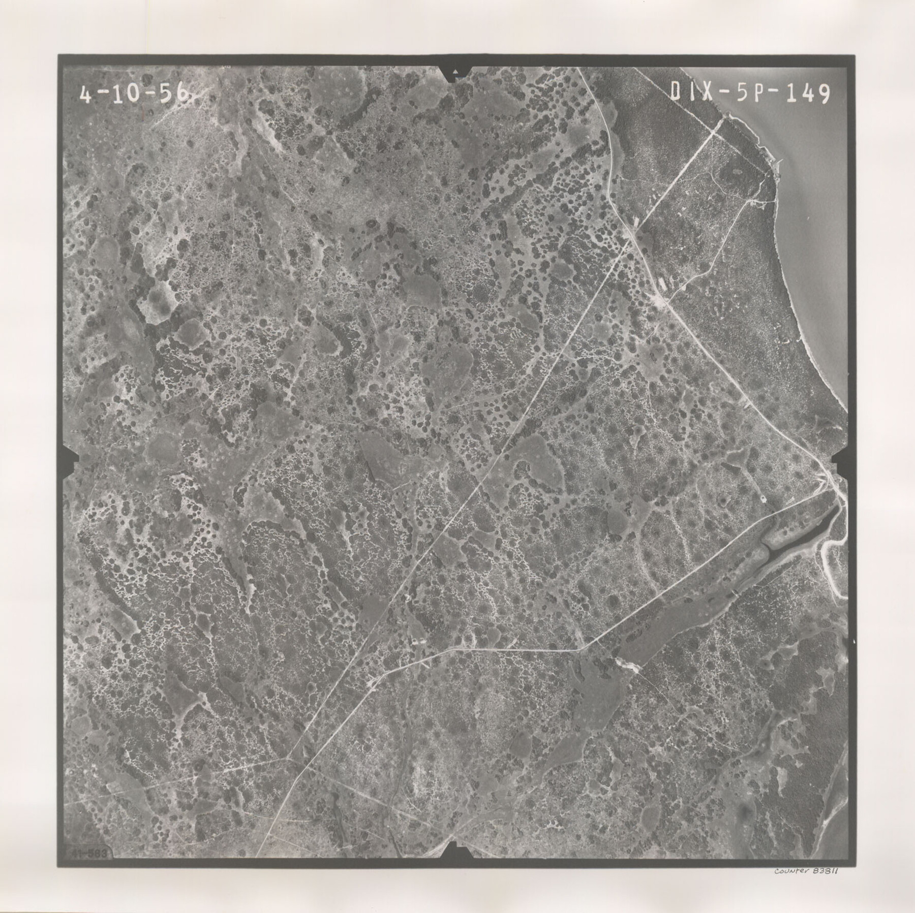
Flight Mission No. DIX-5P, Frame 149, Aransas County
DIX-5P-149
-
Map/Doc
83811
-
Collection
General Map Collection
-
Object Dates
1956/4/10 (Creation Date)
-
People and Organizations
U. S. Department of Agriculture (Publisher)
-
Counties
Aransas
-
Subjects
Aerial Photograph
-
Height x Width
17.8 x 17.8 inches
45.2 x 45.2 cm
-
Comments
Flown by V. L. Beavers and Associates of San Antonio, Texas.
Part of: General Map Collection
Flight Mission No. CGI-1N, Frame 185, Cameron County

Print $20.00
- Digital $50.00
Flight Mission No. CGI-1N, Frame 185, Cameron County
1955
Size 18.6 x 22.2 inches
Map/Doc 84520
Where Did Columbus Discover America?

Where Did Columbus Discover America?
1986
Size 14.7 x 20.6 inches
Map/Doc 96837
Flight Mission No. DQO-3K, Frame 39, Galveston County

Print $20.00
- Digital $50.00
Flight Mission No. DQO-3K, Frame 39, Galveston County
1952
Size 18.8 x 22.5 inches
Map/Doc 85080
Harris County Rolled Sketch 71

Print $20.00
- Digital $50.00
Harris County Rolled Sketch 71
1944
Size 19.3 x 26.7 inches
Map/Doc 6111
Aransas County Boundary File 5b

Print $8.00
- Digital $50.00
Aransas County Boundary File 5b
Size 14.3 x 8.8 inches
Map/Doc 49802
Buenaventura Reyes Grants

Print $20.00
- Digital $50.00
Buenaventura Reyes Grants
1896
Size 14.9 x 13.5 inches
Map/Doc 2057
Austin's colony 1821-1836: In commemoration of the two hundredth birthday of Stephen F. Austin

Print $20.00
- Digital $50.00
Austin's colony 1821-1836: In commemoration of the two hundredth birthday of Stephen F. Austin
1993
Size 24.6 x 34.5 inches
Map/Doc 1675
University Lands, Block 35, Crane & Ector Counties

Print $20.00
- Digital $50.00
University Lands, Block 35, Crane & Ector Counties
1935
Size 39.9 x 45.5 inches
Map/Doc 2406
Map of El Paso County

Print $20.00
- Digital $50.00
Map of El Paso County
1888
Size 47.1 x 39.5 inches
Map/Doc 4942
Colorado County Sketch File 31

Print $4.00
- Digital $50.00
Colorado County Sketch File 31
1838
Size 12.8 x 7.8 inches
Map/Doc 18984
Flight Mission No. BRE-1P, Frame 145, Nueces County

Print $20.00
- Digital $50.00
Flight Mission No. BRE-1P, Frame 145, Nueces County
1956
Size 18.4 x 22.1 inches
Map/Doc 86705
Webb County Sketch File 66

Print $20.00
- Digital $50.00
Webb County Sketch File 66
1950
Size 13.4 x 20.6 inches
Map/Doc 12655
You may also like
Laneer vs. Bivins, Potter County, Texas

Print $20.00
- Digital $50.00
Laneer vs. Bivins, Potter County, Texas
Size 21.1 x 18.8 inches
Map/Doc 93062
[Sketch of surveys in the vicinity of sections 171 and 172 along Pedernales]
![91880, [Sketch of surveys in the vicinity of sections 171 and 172 along Pedernales], Twichell Survey Records](https://historictexasmaps.com/wmedia_w700/maps/91880-1.tif.jpg)
Print $20.00
- Digital $50.00
[Sketch of surveys in the vicinity of sections 171 and 172 along Pedernales]
Size 15.8 x 14.3 inches
Map/Doc 91880

Kaufman County Sketch File 10

Print $4.00
- Digital $50.00
Kaufman County Sketch File 10
1873
Size 10.2 x 8.2 inches
Map/Doc 28643
Live Oak County Boundary File 60d

Print $4.00
- Digital $50.00
Live Oak County Boundary File 60d
Size 14.2 x 8.8 inches
Map/Doc 56423
Copy of Surveyor's Field Book, Morris Browning - In Blocks 7, 5 & 4, I&GNRRCo., Hutchinson and Carson Counties, Texas

Print $2.00
- Digital $50.00
Copy of Surveyor's Field Book, Morris Browning - In Blocks 7, 5 & 4, I&GNRRCo., Hutchinson and Carson Counties, Texas
1888
Size 7.0 x 8.8 inches
Map/Doc 62265
[Sketch showing position of 287.2 acres of land surveyed for W. D. Twichell]
![91904, [Sketch showing position of 287.2 acres of land surveyed for W. D. Twichell], Twichell Survey Records](https://historictexasmaps.com/wmedia_w700/maps/91904-2.tif.jpg)
Print $2.00
- Digital $50.00
[Sketch showing position of 287.2 acres of land surveyed for W. D. Twichell]
1919
Size 15.2 x 7.3 inches
Map/Doc 91904
Brewster County Working Sketch 69

Print $20.00
- Digital $50.00
Brewster County Working Sketch 69
1961
Size 24.5 x 27.5 inches
Map/Doc 67670
Pecos County Rolled Sketch 149

Print $20.00
- Digital $50.00
Pecos County Rolled Sketch 149
1958
Size 36.0 x 38.5 inches
Map/Doc 9735
Bailey County Sketch File 20

Print $40.00
- Digital $50.00
Bailey County Sketch File 20
1948
Size 20.3 x 26.3 inches
Map/Doc 10890
[Blocks M13, S1, C3, JK3, and JK]
![90700, [Blocks M13, S1, C3, JK3, and JK], Twichell Survey Records](https://historictexasmaps.com/wmedia_w700/maps/90700-1.tif.jpg)
Print $20.00
- Digital $50.00
[Blocks M13, S1, C3, JK3, and JK]
Size 26.9 x 15.4 inches
Map/Doc 90700
Map of the St. Louis, Iron Mountain and Southern Railway, and connections

Print $20.00
- Digital $50.00
Map of the St. Louis, Iron Mountain and Southern Railway, and connections
1877
Size 13.0 x 18.9 inches
Map/Doc 95783