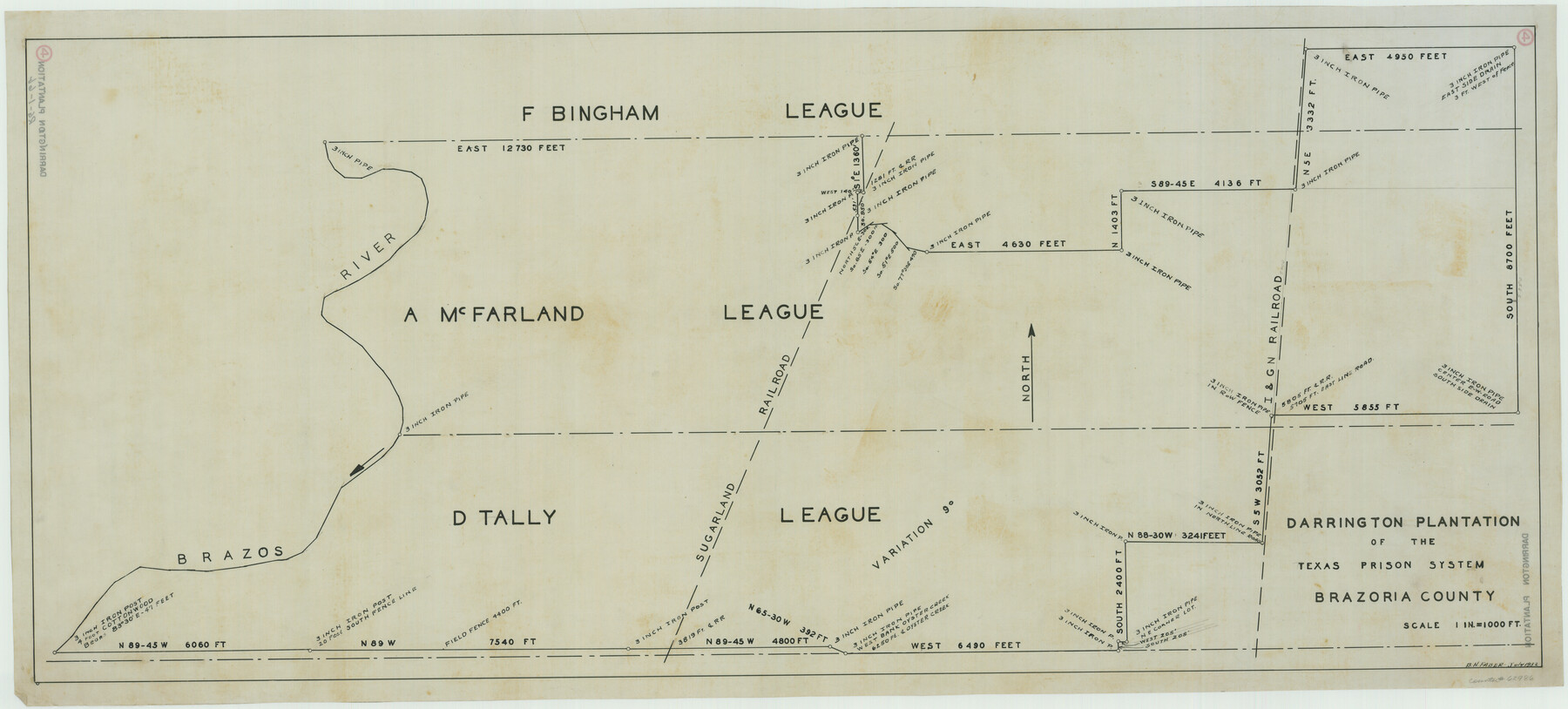
Darrington Plantation of the Texas Prison System, Brazoria County
RG-1-6b
-
Map/Doc
62986
-
Collection
General Map Collection
-
People and Organizations
A.M. Vance (Author)
-
Counties
Brazoria
-
Height x Width
16.9 x 37.4 inches
42.9 x 95.0 cm
Part of: General Map Collection

Montgomery County Working Sketch 41

Print $20.00
- Digital $50.00
Montgomery County Working Sketch 41
1955
Size 22.9 x 23.6 inches
Map/Doc 71148
Lipscomb County

Print $20.00
- Digital $50.00
Lipscomb County
1889
Size 23.5 x 18.5 inches
Map/Doc 3817
Guadalupe County Working Sketch 10

Print $20.00
- Digital $50.00
Guadalupe County Working Sketch 10
1966
Size 21.2 x 27.2 inches
Map/Doc 63319
Calcasieu Pass to Sabine Pass

Print $20.00
- Digital $50.00
Calcasieu Pass to Sabine Pass
1982
Size 45.0 x 36.6 inches
Map/Doc 69814
Atascosa County Boundary File 4

Print $80.00
- Digital $50.00
Atascosa County Boundary File 4
Size 30.6 x 59.2 inches
Map/Doc 50177
Fractional Township No. 8 South Range No. 16 East of the Indian Meridian, Indian Territory

Print $20.00
- Digital $50.00
Fractional Township No. 8 South Range No. 16 East of the Indian Meridian, Indian Territory
1896
Size 19.3 x 24.3 inches
Map/Doc 75228
Henderson County Working Sketch 1

Print $40.00
- Digital $50.00
Henderson County Working Sketch 1
Size 52.6 x 43.8 inches
Map/Doc 66134
Nueces County Rolled Sketch 100

Print $20.00
- Digital $50.00
Nueces County Rolled Sketch 100
Size 21.3 x 32.7 inches
Map/Doc 10697
Gonzales County Working Sketch 11
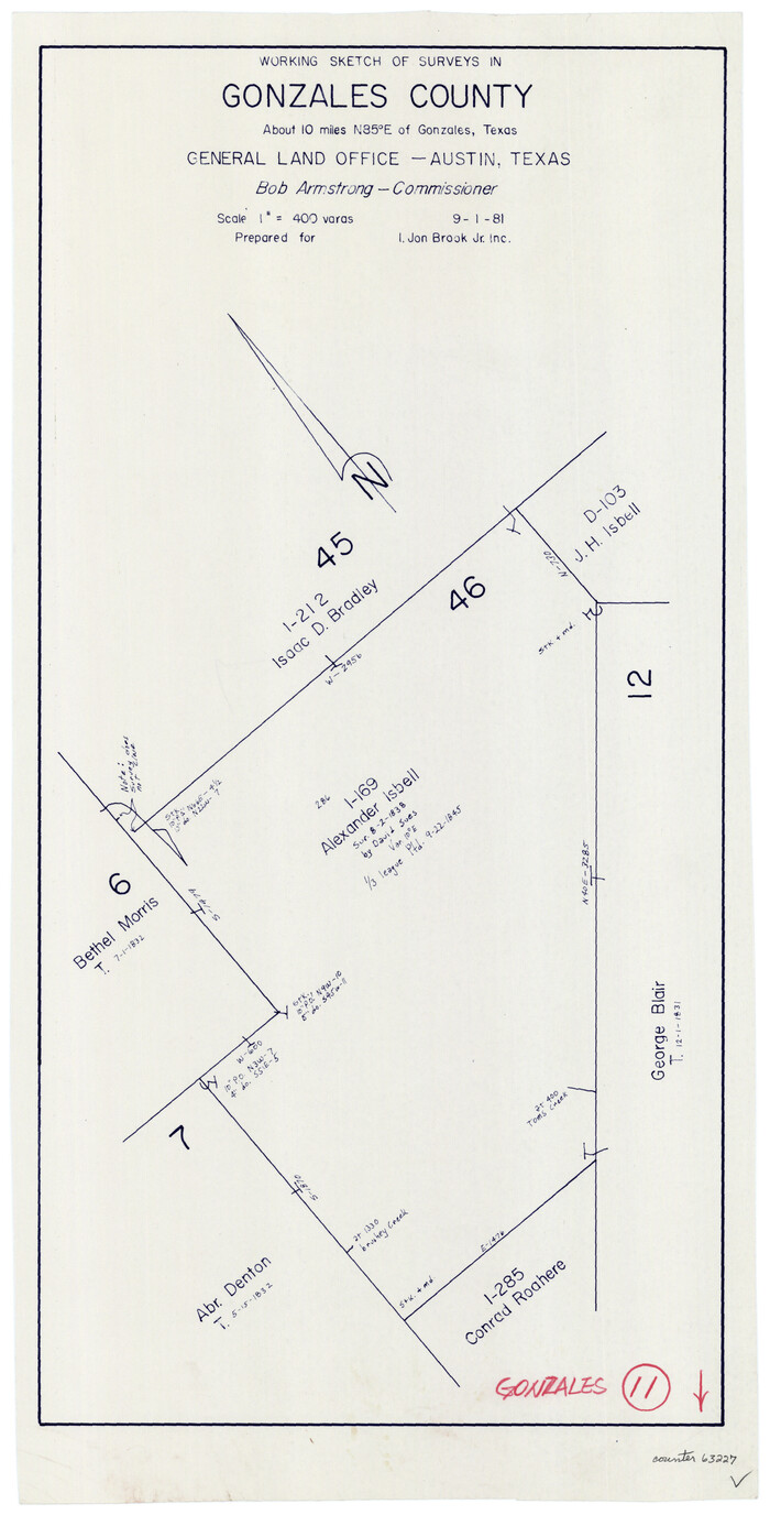
Print $20.00
- Digital $50.00
Gonzales County Working Sketch 11
1981
Size 22.2 x 11.3 inches
Map/Doc 63227
Knox County Working Sketch 6

Print $20.00
- Digital $50.00
Knox County Working Sketch 6
1937
Size 31.4 x 18.2 inches
Map/Doc 70248
Dallas County Working Sketch 15

Print $20.00
- Digital $50.00
Dallas County Working Sketch 15
1980
Size 14.3 x 11.4 inches
Map/Doc 68581
You may also like
Milam County Sketch File 7

Print $6.00
- Digital $50.00
Milam County Sketch File 7
1838
Size 13.0 x 8.0 inches
Map/Doc 31636
Map of the State of Texas from the latest authorities

Print $20.00
- Digital $50.00
Map of the State of Texas from the latest authorities
1854
Size 13.2 x 16.3 inches
Map/Doc 93761
Real County Working Sketch 90

Print $20.00
- Digital $50.00
Real County Working Sketch 90
1991
Size 16.7 x 22.8 inches
Map/Doc 71982
El Paso County Working Sketch 20

Print $20.00
- Digital $50.00
El Paso County Working Sketch 20
1960
Size 28.3 x 26.1 inches
Map/Doc 69042
[Blocks 34-36, Township 3N]
![92028, [Blocks 34-36, Township 3N], Twichell Survey Records](https://historictexasmaps.com/wmedia_w700/maps/92028-1.tif.jpg)
Print $20.00
- Digital $50.00
[Blocks 34-36, Township 3N]
Size 36.5 x 23.7 inches
Map/Doc 92028
Gulf of Mexico

Print $20.00
- Digital $50.00
Gulf of Mexico
1908
Size 18.3 x 26.9 inches
Map/Doc 72655
Jeff Davis County Working Sketch 45

Print $20.00
- Digital $50.00
Jeff Davis County Working Sketch 45
1990
Size 27.8 x 38.1 inches
Map/Doc 66540
San Luis Pass to East Matagorda Bay

Print $20.00
- Digital $50.00
San Luis Pass to East Matagorda Bay
1960
Size 34.6 x 46.5 inches
Map/Doc 69963
King County Sketch File 9

Print $20.00
- Digital $50.00
King County Sketch File 9
Size 23.5 x 33.0 inches
Map/Doc 11937
Reeves County Sketch File 18

Print $40.00
- Digital $50.00
Reeves County Sketch File 18
1926
Size 22.2 x 9.4 inches
Map/Doc 35210
Bowie County Working Sketch 12

Print $20.00
- Digital $50.00
Bowie County Working Sketch 12
1959
Size 31.3 x 23.3 inches
Map/Doc 67416
Collingsworth County Sketch File 11

Print $32.00
- Digital $50.00
Collingsworth County Sketch File 11
1991
Size 11.2 x 8.6 inches
Map/Doc 18893