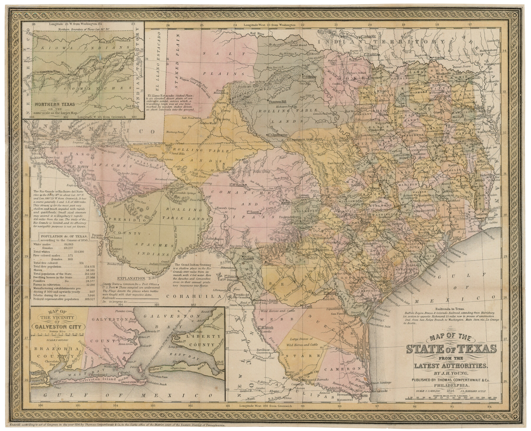
Map of the State of Texas from the latest authorities
[Inset 1: Northern Texas / Inset 2: Map of the vicinity of Galveston City]
-
Map/Doc
93761
-
Collection
Rees-Jones Digital Map Collection
-
Object Dates
1854 (Creation Date)
-
People and Organizations
Thomas, Cowperthwait & Co. (Publisher)
J. L. Hazzard (Printer)
J.H. Young (Author)
-
Subjects
State of Texas
-
Height x Width
13.2 x 16.3 inches
33.5 x 41.4 cm
-
Comments
Courtesy of the Rees-Jones Collection, Dallas, TX
Part of: Rees-Jones Digital Map Collection
Part of the boundary between the United States and Texas; north of Sabine River, from the 72nd mile mound to the Red River

Print $3.00
- Digital $50.00
Part of the boundary between the United States and Texas; north of Sabine River, from the 72nd mile mound to the Red River
1842
Size 12.8 x 8.1 inches
Map/Doc 93771
Map of the Oregon Territory by the U.S. Ex. Ex.

Print $20.00
- Digital $50.00
Map of the Oregon Territory by the U.S. Ex. Ex.
1841
Size 26.2 x 37.3 inches
Map/Doc 94060
Map of Texas With Parts of the Adjoining States

Print $20.00
- Digital $50.00
Map of Texas With Parts of the Adjoining States
1836
Size 30.9 x 24.8 inches
Map/Doc 93932
Outline Map showing a new route from Texas to Fort Yuma, California for cattle droves and trains en route to California

Print $40.00
- Digital $50.00
Outline Map showing a new route from Texas to Fort Yuma, California for cattle droves and trains en route to California
1870
Size 17.3 x 52.7 inches
Map/Doc 94048
Map of the State of Texas from the latest authorities

Print $20.00
- Digital $50.00
Map of the State of Texas from the latest authorities
1854
Size 13.2 x 16.3 inches
Map/Doc 93761
A New Map of Texas with the Contiguous American & Mexican States

Print $20.00
- Digital $50.00
A New Map of Texas with the Contiguous American & Mexican States
1839
Size 13.5 x 16.1 inches
Map/Doc 93941
Traveller's Map of the State of Texas

Print $20.00
- Digital $50.00
Traveller's Map of the State of Texas
1867
Size 43.6 x 41.7 inches
Map/Doc 93935
New Map of the Mining Regions of Idaho and Montana showing the geographical positions of the Blackfoot, Owyhee & South Boise Mines and the various routes thereto

Print $20.00
- Digital $50.00
New Map of the Mining Regions of Idaho and Montana showing the geographical positions of the Blackfoot, Owyhee & South Boise Mines and the various routes thereto
Size 21.9 x 29.4 inches
Map/Doc 93991
Nebraska and Kansas

Print $20.00
- Digital $50.00
Nebraska and Kansas
Size 14.7 x 16.7 inches
Map/Doc 93997
A map of the Anthracite Coal Fields of Pennsylvania embracing all of Schuylkill County and parts of Carbon, Luzerne, Columbia, Northumberland, Dauphin, and Lebanon Counties

Print $20.00
- Digital $50.00
A map of the Anthracite Coal Fields of Pennsylvania embracing all of Schuylkill County and parts of Carbon, Luzerne, Columbia, Northumberland, Dauphin, and Lebanon Counties
1863
Size 27.1 x 39.3 inches
Map/Doc 94054
Map of Arizona prepared specially for R.J. Hinton's handbook of Arizona

Print $20.00
- Digital $50.00
Map of Arizona prepared specially for R.J. Hinton's handbook of Arizona
1877
Size 36.4 x 25.7 inches
Map/Doc 94062
J. De Cordova's Map of the State of Texas Compiled from the records of the General Land Office of the State

Print $20.00
- Digital $50.00
J. De Cordova's Map of the State of Texas Compiled from the records of the General Land Office of the State
1861
Size 36.9 x 34.9 inches
Map/Doc 93931
You may also like
Hardin County Sketch File 69

Print $20.00
- Digital $50.00
Hardin County Sketch File 69
1944
Size 25.1 x 22.0 inches
Map/Doc 11641
Comal County Working Sketch 9

Print $20.00
- Digital $50.00
Comal County Working Sketch 9
1972
Size 29.0 x 30.4 inches
Map/Doc 68175
Knox County Sketch File 1-1a

Print $30.00
- Digital $50.00
Knox County Sketch File 1-1a
1872
Size 8.2 x 12.4 inches
Map/Doc 29212
Taylor County Working Sketch 3

Print $20.00
- Digital $50.00
Taylor County Working Sketch 3
1939
Size 15.2 x 19.2 inches
Map/Doc 69612
Erath County Rolled Sketch 2

Print $20.00
- Digital $50.00
Erath County Rolled Sketch 2
Size 21.0 x 25.9 inches
Map/Doc 5861
McLennan County Sketch File 1b

Print $4.00
- Digital $50.00
McLennan County Sketch File 1b
Size 8.3 x 8.1 inches
Map/Doc 31228
Brewster County Sketch File NS-10

Print $136.00
- Digital $50.00
Brewster County Sketch File NS-10
1947
Size 14.3 x 9.0 inches
Map/Doc 16153
Dallas County Working Sketch Graphic Index

Print $20.00
- Digital $50.00
Dallas County Working Sketch Graphic Index
1942
Size 43.9 x 36.7 inches
Map/Doc 76517
Sutton County Working Sketch 41

Print $20.00
- Digital $50.00
Sutton County Working Sketch 41
1950
Size 22.4 x 33.8 inches
Map/Doc 62384
Map of the Location Survey of the Hearne & Brazos Valley Railroad

Print $40.00
- Digital $50.00
Map of the Location Survey of the Hearne & Brazos Valley Railroad
1891
Size 40.7 x 122.9 inches
Map/Doc 64347
Flight Mission No. BRA-7M, Frame 123, Jefferson County

Print $20.00
- Digital $50.00
Flight Mission No. BRA-7M, Frame 123, Jefferson County
1953
Size 18.7 x 22.3 inches
Map/Doc 85517
Reagan County Rolled Sketch 8

Print $20.00
- Digital $50.00
Reagan County Rolled Sketch 8
Size 30.2 x 26.7 inches
Map/Doc 7436