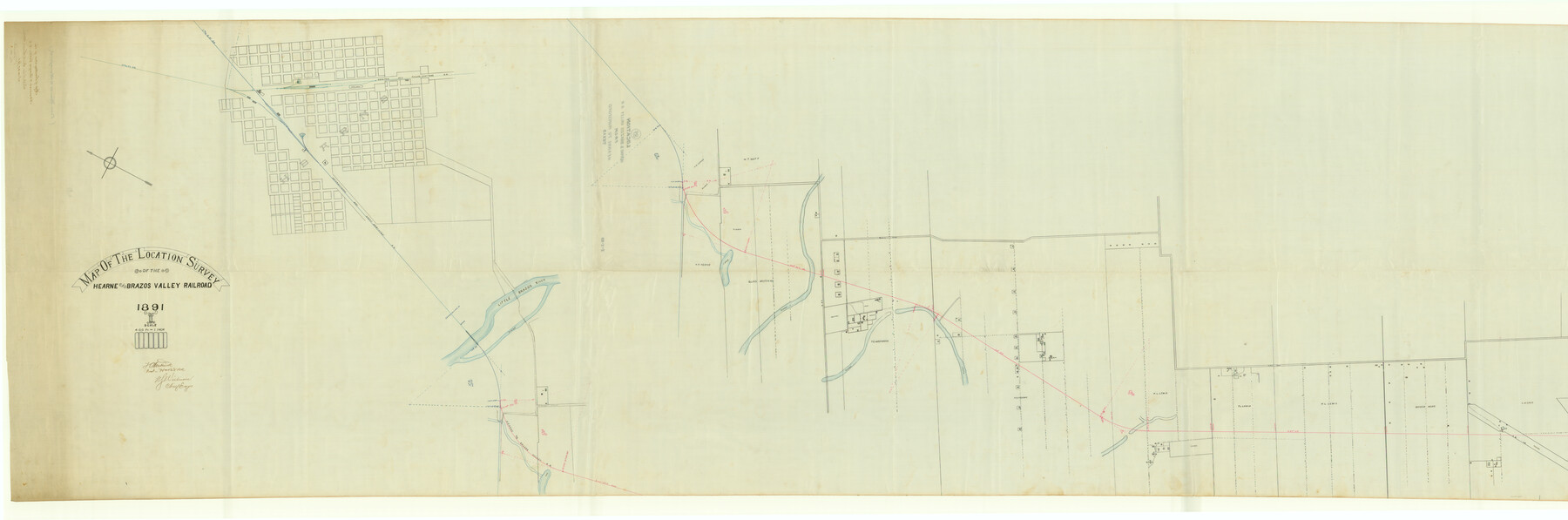
Map of the Location Survey of the Hearne & Brazos Valley Railroad
Z-2-89
-
Map/Doc
64347
-
Collection
General Map Collection
-
Object Dates
1891/11/27 (File Date)
1891 (Creation Date)
-
Counties
Robertson
-
Subjects
Railroads
-
Height x Width
40.7 x 122.9 inches
103.4 x 312.2 cm
-
Medium
linen, manuscript
-
Scale
400 ft = 1 inch
-
Comments
From Hearne to Mumford. See 64348 for other segment.
-
Features
H&BV
H&TC
I&GN
Little Brazos River
Slough of Little Brazos River
Untitled Lake
Public Road
Hearne
Part of: General Map Collection

Trinity River, Balltown Sheet/Pilot Grove Creek

Print $20.00
- Digital $50.00
Trinity River, Balltown Sheet/Pilot Grove Creek
1916
Size 36.9 x 27.5 inches
Map/Doc 65195
Martin County Sketch File 10

Print $50.00
- Digital $50.00
Martin County Sketch File 10
Size 11.2 x 8.8 inches
Map/Doc 30644
Archer County Working Sketch 4

Print $40.00
- Digital $50.00
Archer County Working Sketch 4
1918
Size 49.9 x 68.3 inches
Map/Doc 67144
Orange County Working Sketch 4

Print $20.00
- Digital $50.00
Orange County Working Sketch 4
Size 18.8 x 12.3 inches
Map/Doc 71336
Comanche County Working Sketch 21

Print $20.00
- Digital $50.00
Comanche County Working Sketch 21
1973
Size 28.0 x 26.1 inches
Map/Doc 68155
Sketch of Surveys on Caranchua and Tres Palacious Bayous, Jackson Co.

Print $2.00
- Digital $50.00
Sketch of Surveys on Caranchua and Tres Palacious Bayous, Jackson Co.
Size 7.9 x 7.8 inches
Map/Doc 69743
Hood County Sketch File 26

Print $5.00
- Digital $50.00
Hood County Sketch File 26
1921
Size 23.6 x 28.0 inches
Map/Doc 11782
Harris County Historic Topographic 5

Print $20.00
- Digital $50.00
Harris County Historic Topographic 5
1916
Size 29.2 x 22.8 inches
Map/Doc 65815
Yoakum County Boundary File 1a

Print $20.00
- Digital $50.00
Yoakum County Boundary File 1a
Size 7.8 x 29.5 inches
Map/Doc 60196
Flight Mission No. BRE-2P, Frame 45, Nueces County

Print $20.00
- Digital $50.00
Flight Mission No. BRE-2P, Frame 45, Nueces County
1956
Size 18.6 x 22.6 inches
Map/Doc 86747
Angelina County Working Sketch 30

Print $20.00
- Digital $50.00
Angelina County Working Sketch 30
1955
Size 26.2 x 27.7 inches
Map/Doc 67112
You may also like
[Block V and surrounding surveys]
![90293, [Block V and surrounding surveys], Twichell Survey Records](https://historictexasmaps.com/wmedia_w700/maps/90293-1.tif.jpg)
Print $20.00
- Digital $50.00
[Block V and surrounding surveys]
Size 12.0 x 12.6 inches
Map/Doc 90293
Zavala County Boundary File 1

Print $48.00
- Digital $50.00
Zavala County Boundary File 1
Size 12.8 x 8.3 inches
Map/Doc 60233
Travis County Sketch File 73

Print $8.00
- Digital $50.00
Travis County Sketch File 73
1848
Size 12.8 x 8.3 inches
Map/Doc 38464
Presidio County Working Sketch 121a

Print $20.00
- Digital $50.00
Presidio County Working Sketch 121a
Size 34.2 x 38.0 inches
Map/Doc 71798
Flight Mission No. BRE-1P, Frame 102, Nueces County

Print $20.00
- Digital $50.00
Flight Mission No. BRE-1P, Frame 102, Nueces County
1956
Size 18.5 x 22.4 inches
Map/Doc 86673
Medina County Working Sketch 5

Print $20.00
- Digital $50.00
Medina County Working Sketch 5
1949
Size 38.5 x 37.3 inches
Map/Doc 70920
Map of Kendall County

Print $20.00
- Digital $50.00
Map of Kendall County
1899
Size 36.7 x 34.4 inches
Map/Doc 4999
Anderson County Working Sketch 16

Print $20.00
- Digital $50.00
Anderson County Working Sketch 16
1938
Size 42.4 x 37.1 inches
Map/Doc 67016
Zavala County Working Sketch 29

Print $20.00
- Digital $50.00
Zavala County Working Sketch 29
1994
Size 33.1 x 42.9 inches
Map/Doc 62104
Packery Channel

Print $2.00
- Digital $50.00
Packery Channel
1971
Size 9.2 x 9.1 inches
Map/Doc 2998
Flight Mission No. CRK-8P, Frame 118, Refugio County

Print $20.00
- Digital $50.00
Flight Mission No. CRK-8P, Frame 118, Refugio County
1956
Size 18.3 x 22.1 inches
Map/Doc 86973
Brewster County Rolled Sketch 29

Print $20.00
- Digital $50.00
Brewster County Rolled Sketch 29
1910
Size 17.5 x 18.5 inches
Map/Doc 5216