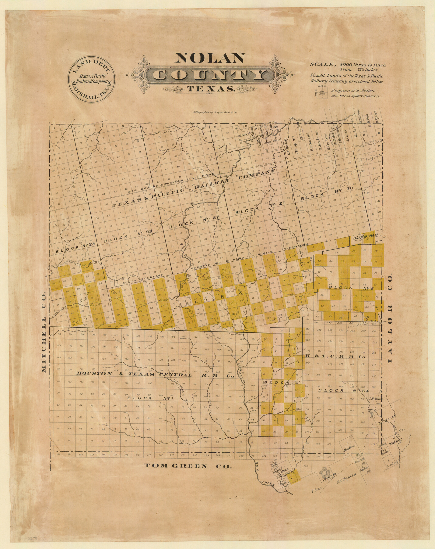
Nolan County, Texas
-
Map/Doc
744
-
Collection
Maddox Collection
-
Object Dates
[1870 ca.] (Creation Date)
-
People and Organizations
Texas and Pacific Railroad Company (Publisher)
August Gast & Co. (Lithographer)
-
Counties
Nolan
-
Subjects
County
-
Height x Width
23.9 x 19.5 inches
60.7 x 49.5 cm
-
Medium
paper, etching/engraving/lithograph
-
Scale
1" = 4000 varas
-
Comments
Conservation funded in 2012 by Friends of the Texas General Land Office.
-
Features
Little Elm Fork
Big Spring and Phantom Hill Road
Big Spring Road
Phantom Hill Road
Champlain's Creek
Little Elm or Sweet Water [River]
Little Elm River
Sweet Water River
Clear Fork
Silver Creek
Kuechler's Creek
McKinney's Creek
Hoffman's Creek
Valley Creek
Church Mountain
Oak Creek
Part of: Maddox Collection

Part of original sketch of Block "H" W. & N. W. Ry. Co. Cottle County

Print $20.00
- Digital $50.00
Part of original sketch of Block "H" W. & N. W. Ry. Co. Cottle County
Size 13.7 x 14.6 inches
Map/Doc 10776
Map of Tyler County, Texas

Print $20.00
- Digital $50.00
Map of Tyler County, Texas
1881
Size 22.3 x 24.2 inches
Map/Doc 762
Map of Fort Bend County, Texas

Print $20.00
- Digital $50.00
Map of Fort Bend County, Texas
1882
Size 23.0 x 25.7 inches
Map/Doc 434
Map of Rockport Texas, Aransas County

Print $20.00
- Digital $50.00
Map of Rockport Texas, Aransas County
1888
Size 29.0 x 20.5 inches
Map/Doc 380
Borden County, Texas

Print $20.00
- Digital $50.00
Borden County, Texas
1892
Size 25.7 x 20.9 inches
Map/Doc 394
Map of part of Presidio Co. Texas

Print $20.00
- Digital $50.00
Map of part of Presidio Co. Texas
Size 16.5 x 21.3 inches
Map/Doc 75769
Sketch of Dickens Co.

Print $20.00
- Digital $50.00
Sketch of Dickens Co.
1884
Size 17.6 x 14.5 inches
Map/Doc 75766
Map of Lands in King County, Texas owned and leased by the Louisville Land and Cattle Company

Print $20.00
- Digital $50.00
Map of Lands in King County, Texas owned and leased by the Louisville Land and Cattle Company
Size 32.1 x 25.9 inches
Map/Doc 5070
Part of Tom Green County, Texas (No. 1)

Print $20.00
- Digital $50.00
Part of Tom Green County, Texas (No. 1)
1870
Size 22.8 x 17.7 inches
Map/Doc 759
[Sketch Showing Surveys in Dimmit County, Texas]
![5045, [Sketch Showing Surveys in Dimmit County, Texas], Maddox Collection](https://historictexasmaps.com/wmedia_w700/maps/5045.tif.jpg)
Print $20.00
- Digital $50.00
[Sketch Showing Surveys in Dimmit County, Texas]
Size 20.1 x 16.7 inches
Map/Doc 5045
[Mary L. Williams or Lydia Glasgow Survey, Bastrop County, Texas]
![572, [Mary L. Williams or Lydia Glasgow Survey, Bastrop County, Texas], Maddox Collection](https://historictexasmaps.com/wmedia_w700/maps/0572-1.tif.jpg)
Print $3.00
- Digital $50.00
[Mary L. Williams or Lydia Glasgow Survey, Bastrop County, Texas]
Size 11.9 x 15.6 inches
Map/Doc 572
You may also like
Pecos County Working Sketch Graphic Index - northeast part - sheet B

Print $20.00
- Digital $50.00
Pecos County Working Sketch Graphic Index - northeast part - sheet B
1975
Size 36.0 x 42.2 inches
Map/Doc 76667
Working Sketch Armstrong County

Print $20.00
- Digital $50.00
Working Sketch Armstrong County
1909
Size 32.0 x 23.8 inches
Map/Doc 90264
Tyler County Sketch File 19a

Print $4.00
- Digital $50.00
Tyler County Sketch File 19a
Size 8.1 x 14.1 inches
Map/Doc 38672
[Atchison, Topeka & Santa Fe from Paisano to south of Plata]
![64713, [Atchison, Topeka & Santa Fe from Paisano to south of Plata], General Map Collection](https://historictexasmaps.com/wmedia_w700/maps/64713-1.tif.jpg)
Print $40.00
- Digital $50.00
[Atchison, Topeka & Santa Fe from Paisano to south of Plata]
Size 32.2 x 116.3 inches
Map/Doc 64713
Sterling County Rolled Sketch 35

Print $20.00
- Digital $50.00
Sterling County Rolled Sketch 35
1960
Size 20.8 x 21.8 inches
Map/Doc 7859
Madison County Working Sketch 5

Print $20.00
- Digital $50.00
Madison County Working Sketch 5
1981
Size 24.0 x 24.1 inches
Map/Doc 70767
Harris County Sketch File 69a

Print $20.00
- Digital $50.00
Harris County Sketch File 69a
1938
Size 19.4 x 21.3 inches
Map/Doc 11663
Hansford County

Print $20.00
- Digital $50.00
Hansford County
1902
Size 38.8 x 34.9 inches
Map/Doc 4696
Lamb County Rolled Sketch 9

Print $20.00
- Digital $50.00
Lamb County Rolled Sketch 9
Size 44.7 x 27.9 inches
Map/Doc 9417
Nautical Chart 892-SC - Intracoastal Waterway - Carlos Bay to Redfish Bay including Copano Bay, Texas

Print $20.00
- Digital $50.00
Nautical Chart 892-SC - Intracoastal Waterway - Carlos Bay to Redfish Bay including Copano Bay, Texas
1972
Size 16.0 x 18.7 inches
Map/Doc 75912
Brazos Santiago

Print $20.00
- Digital $50.00
Brazos Santiago
1884
Size 24.4 x 18.2 inches
Map/Doc 73030
Flight Mission No. DQN-3K, Frame 35, Calhoun County

Print $20.00
- Digital $50.00
Flight Mission No. DQN-3K, Frame 35, Calhoun County
1953
Size 16.4 x 16.2 inches
Map/Doc 84348