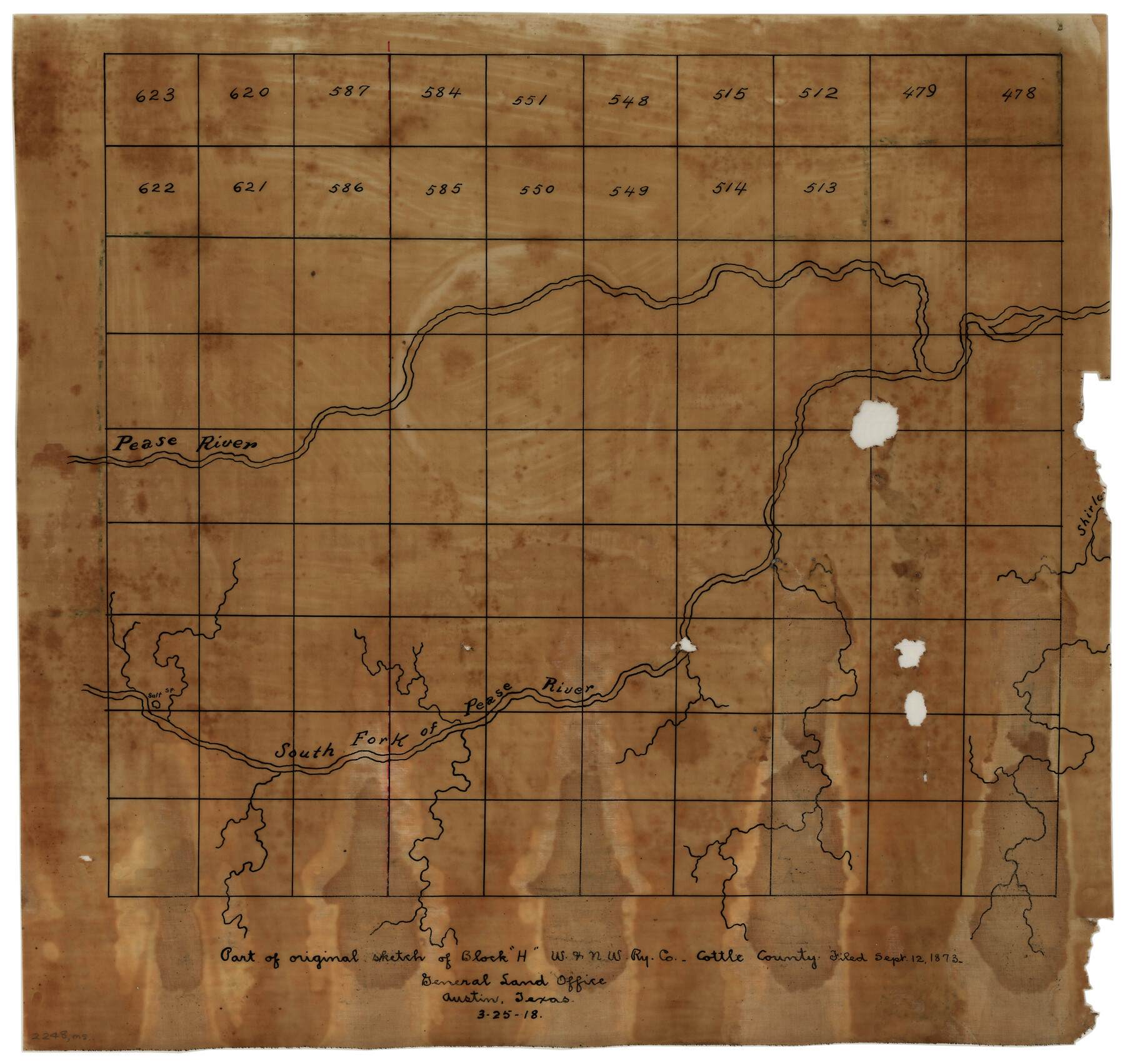
Part of original sketch of Block "H" W. & N. W. Ry. Co. Cottle County
-
Map/Doc
10776
-
Collection
Maddox Collection
-
Object Dates
3/25/1918 (Creation Date)
-
Counties
Cottle
-
Height x Width
13.7 x 14.6 inches
34.8 x 37.1 cm
-
Medium
paper, manuscript
-
Comments
Tracing of counter 613.
-
Features
Pease River
South Fork of Pease River
shirle[y's] Creek
Salt Sp[rings]
Part of: Maddox Collection
Working Sketch in Cottle, Foard & Hardeman Counties

Print $20.00
- Digital $50.00
Working Sketch in Cottle, Foard & Hardeman Counties
1917
Size 26.9 x 28.0 inches
Map/Doc 4485
[Sketch showing Miguel Perez, Juan Jose Solis and Francisco Antonio Villareal surveys in Starr County]
![75549, [Sketch showing Miguel Perez, Juan Jose Solis and Francisco Antonio Villareal surveys in Starr County], Maddox Collection](https://historictexasmaps.com/wmedia_w700/maps/75549.tif.jpg)
Print $20.00
- Digital $50.00
[Sketch showing Miguel Perez, Juan Jose Solis and Francisco Antonio Villareal surveys in Starr County]
1914
Size 20.9 x 13.6 inches
Map/Doc 75549
Copy of sketch in Nacogdoches Donation 724 on file in GLO

Print $20.00
- Digital $50.00
Copy of sketch in Nacogdoches Donation 724 on file in GLO
1890
Size 18.0 x 10.9 inches
Map/Doc 75803
Sketch of surveys in Dimmit, Maverick and Webb Cos.

Print $20.00
- Digital $50.00
Sketch of surveys in Dimmit, Maverick and Webb Cos.
1876
Size 17.9 x 14.7 inches
Map/Doc 5050
[Sketch Showing Surveys in Schleicher, Menard & Concho Counties, Texas]
![75782, [Sketch Showing Surveys in Schleicher, Menard & Concho Counties, Texas], Maddox Collection](https://historictexasmaps.com/wmedia_w700/maps/75782.tif.jpg)
Print $20.00
- Digital $50.00
[Sketch Showing Surveys in Schleicher, Menard & Concho Counties, Texas]
Size 16.1 x 28.9 inches
Map/Doc 75782
[Sketch of Surveys in Brooks County, Texas]
![10775, [Sketch of Surveys in Brooks County, Texas], Maddox Collection](https://historictexasmaps.com/wmedia_w700/maps/10775-1.tif.jpg)
Print $20.00
- Digital $50.00
[Sketch of Surveys in Brooks County, Texas]
Size 12.1 x 12.4 inches
Map/Doc 10775
Revised Sectional Map No. 6 showing land surveys in parts of Presidio and Brewster Counties, Texas

Print $20.00
- Digital $50.00
Revised Sectional Map No. 6 showing land surveys in parts of Presidio and Brewster Counties, Texas
Size 24.2 x 23.0 inches
Map/Doc 4475
[Surveying sketch of M.K. McDermott, T. C. R.R. Co., I. & G. N. Ry. Co., et al in Williamson County]
![407, [Surveying sketch of M.K. McDermott, T. C. R.R. Co., I. & G. N. Ry. Co., et al in Williamson County], Maddox Collection](https://historictexasmaps.com/wmedia_w700/maps/407.tif.jpg)
Print $3.00
- Digital $50.00
[Surveying sketch of M.K. McDermott, T. C. R.R. Co., I. & G. N. Ry. Co., et al in Williamson County]
1889
Size 11.5 x 12.6 inches
Map/Doc 407
Montgomery County, Texas

Print $20.00
- Digital $50.00
Montgomery County, Texas
1880
Size 24.6 x 27.6 inches
Map/Doc 582
San Patricio County, Texas

Print $20.00
- Digital $50.00
San Patricio County, Texas
1879
Size 18.1 x 22.8 inches
Map/Doc 611
Topography and water depth as shown by the U.S. Coast Survey of 1888

Print $20.00
- Digital $50.00
Topography and water depth as shown by the U.S. Coast Survey of 1888
1890
Size 17.0 x 18.8 inches
Map/Doc 390
Austin and Surrounding Properties
.tif.jpg)
Print $20.00
- Digital $50.00
Austin and Surrounding Properties
1891
Size 42.9 x 32.1 inches
Map/Doc 421
You may also like
Eastland County Working Sketch 65

Print $20.00
- Digital $50.00
Eastland County Working Sketch 65
1986
Size 37.4 x 16.5 inches
Map/Doc 88892
Pecos County Rolled Sketch 29

Print $40.00
- Digital $50.00
Pecos County Rolled Sketch 29
1890
Size 27.3 x 49.9 inches
Map/Doc 9690
Terrell County Rolled Sketch 52

Print $20.00
- Digital $50.00
Terrell County Rolled Sketch 52
1967
Size 26.8 x 30.5 inches
Map/Doc 7970
Gaines County Rolled Sketch 13

Print $40.00
- Digital $50.00
Gaines County Rolled Sketch 13
Size 70.1 x 23.1 inches
Map/Doc 9029
Starr County Boundary File 44

Print $98.00
- Digital $50.00
Starr County Boundary File 44
Size 8.8 x 12.8 inches
Map/Doc 58818
Sketch of a portion of the Texas Coast showing the relative positions of different harbours with the interior Military Posts, and the roads communicating with them, also two new routes from Black Point and Lamar to San Antonio

Print $20.00
- Digital $50.00
Sketch of a portion of the Texas Coast showing the relative positions of different harbours with the interior Military Posts, and the roads communicating with them, also two new routes from Black Point and Lamar to San Antonio
1855
Size 27.3 x 18.3 inches
Map/Doc 72709
Roberts County Working Sketch 42

Print $20.00
- Digital $50.00
Roberts County Working Sketch 42
1978
Size 26.7 x 22.7 inches
Map/Doc 63568
Henderson County Rolled Sketch 11

Print $20.00
- Digital $50.00
Henderson County Rolled Sketch 11
1915
Size 29.4 x 42.2 inches
Map/Doc 75949
Real County Rolled Sketch 6

Print $20.00
- Digital $50.00
Real County Rolled Sketch 6
Size 28.0 x 23.7 inches
Map/Doc 7456
[Vicinity of Wilson Strickland Survey]
![91379, [Vicinity of Wilson Strickland Survey], Twichell Survey Records](https://historictexasmaps.com/wmedia_w700/maps/91379-1.tif.jpg)
Print $20.00
- Digital $50.00
[Vicinity of Wilson Strickland Survey]
Size 35.9 x 33.3 inches
Map/Doc 91379
Fort Bend County Sketch File 17 1/2

Print $52.00
- Digital $50.00
Fort Bend County Sketch File 17 1/2
1896
Size 11.2 x 8.7 inches
Map/Doc 22934
Hudspeth County Working Sketch 41

Print $20.00
- Digital $50.00
Hudspeth County Working Sketch 41
1981
Size 18.3 x 37.1 inches
Map/Doc 66326