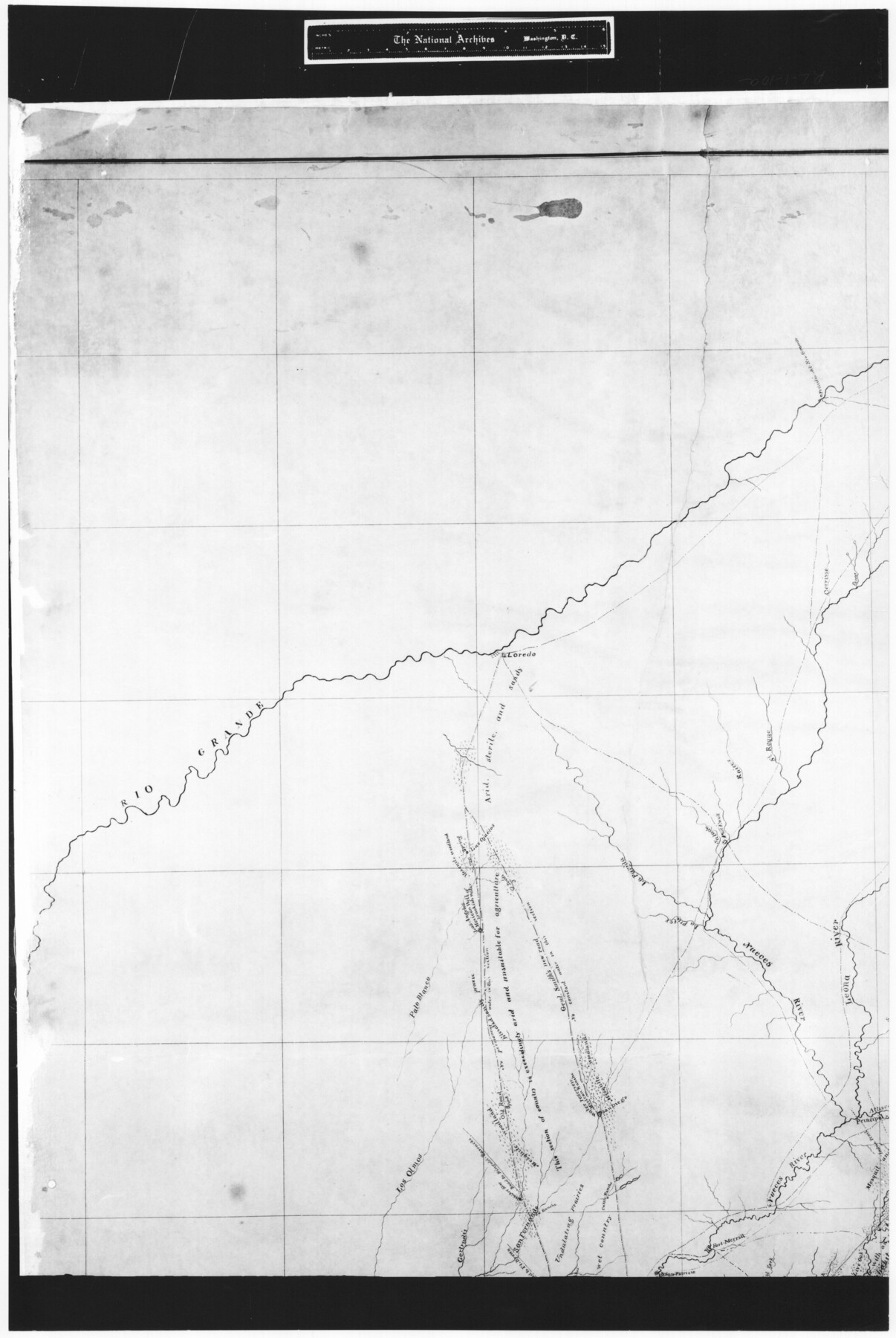
Sketch of a portion of the Texas Coast showing the relative positions of different harbours with the interior Military Posts, and the roads communicating with them, also two new routes from Black Point and Lamar to San Antonio
RL-1-10a
-
Map/Doc
72709
-
Collection
General Map Collection
-
Object Dates
1855 (Creation Date)
-
People and Organizations
R.B. Marcy (Author)
R.B. Marcy (Surveyor/Engineer)
R.B. Marcy (Compiler)
-
Subjects
Military
-
Height x Width
27.3 x 18.3 inches
69.3 x 46.5 cm
-
Comments
B/W photostat copy from National Archives in multiple pieces.
Part of: General Map Collection
Brazoria County Sketch File 41

Print $40.00
- Digital $50.00
Brazoria County Sketch File 41
1939
Size 19.5 x 26.6 inches
Map/Doc 10960
[Map Showing Location and Right of Way of Proposed Groins]
![73623, [Map Showing Location and Right of Way of Proposed Groins], General Map Collection](https://historictexasmaps.com/wmedia_w700/maps/73623-1.tif.jpg)
Print $4.00
- Digital $50.00
[Map Showing Location and Right of Way of Proposed Groins]
Size 13.4 x 24.4 inches
Map/Doc 73623
Bexar County Working Sketch 2

Print $20.00
- Digital $50.00
Bexar County Working Sketch 2
1940
Size 24.8 x 27.9 inches
Map/Doc 67318
List of County School Lands

Print $20.00
- Digital $50.00
List of County School Lands
Size 18.4 x 23.4 inches
Map/Doc 65798
Township No. 1 North Range No. 26 West of the Indian Meridian

Print $20.00
- Digital $50.00
Township No. 1 North Range No. 26 West of the Indian Meridian
1874
Size 19.3 x 24.4 inches
Map/Doc 75171
Bee County Working Sketch 11

Print $20.00
- Digital $50.00
Bee County Working Sketch 11
1942
Size 19.8 x 24.4 inches
Map/Doc 67261
Brazoria County Sketch File 58

Print $30.00
- Digital $50.00
Brazoria County Sketch File 58
1992
Size 11.5 x 9.0 inches
Map/Doc 15382
Fort Bend County Sketch File 1

Print $6.00
- Digital $50.00
Fort Bend County Sketch File 1
Size 14.7 x 9.5 inches
Map/Doc 22876
[Surveys on Cibolo Creek]
![363, [Surveys on Cibolo Creek], General Map Collection](https://historictexasmaps.com/wmedia_w700/maps/363.tif.jpg)
Print $2.00
- Digital $50.00
[Surveys on Cibolo Creek]
Size 7.4 x 6.7 inches
Map/Doc 363
Atascosa County Rolled Sketch 7

Print $20.00
- Digital $50.00
Atascosa County Rolled Sketch 7
1913
Size 26.1 x 26.7 inches
Map/Doc 5092
Padre Island National Seashore

Print $4.00
- Digital $50.00
Padre Island National Seashore
Size 16.0 x 22.0 inches
Map/Doc 60529
Orange County Working Sketch 33

Print $20.00
- Digital $50.00
Orange County Working Sketch 33
1957
Size 26.1 x 18.4 inches
Map/Doc 71365
You may also like
Trace of a copy of the map captured at the battle of Resaca de la Palma

Print $20.00
- Digital $50.00
Trace of a copy of the map captured at the battle of Resaca de la Palma
Size 18.3 x 27.3 inches
Map/Doc 73056
Liberty County Sketch File 27

Print $5.00
- Digital $50.00
Liberty County Sketch File 27
Size 11.5 x 9.3 inches
Map/Doc 29948
Starr County Sketch File 9

Print $22.00
- Digital $50.00
Starr County Sketch File 9
Size 9.1 x 7.9 inches
Map/Doc 36861
[East Line of Lipscomb County]
![91306, [East Line of Lipscomb County], Twichell Survey Records](https://historictexasmaps.com/wmedia_w700/maps/91306-1.tif.jpg)
Print $20.00
- Digital $50.00
[East Line of Lipscomb County]
Size 8.9 x 27.2 inches
Map/Doc 91306

Cherokee County Working Sketch 23

Print $20.00
- Digital $50.00
Cherokee County Working Sketch 23
1972
Size 44.4 x 46.9 inches
Map/Doc 67978
Texas State Boundary Line 3

Print $90.00
- Digital $50.00
Texas State Boundary Line 3
Size 10.9 x 8.2 inches
Map/Doc 74904
Hall County Boundary File 1c

Print $40.00
- Digital $50.00
Hall County Boundary File 1c
Size 10.0 x 34.6 inches
Map/Doc 54175
Cass County Working Sketch 5

Print $20.00
- Digital $50.00
Cass County Working Sketch 5
1936
Size 45.6 x 43.1 inches
Map/Doc 67908
La Salle County Working Sketch 40

Print $20.00
- Digital $50.00
La Salle County Working Sketch 40
1968
Size 23.0 x 19.2 inches
Map/Doc 70341

Collingsworth County Rolled Sketch 1

Print $40.00
- Digital $50.00
Collingsworth County Rolled Sketch 1
1941
Size 54.2 x 24.0 inches
Map/Doc 9664