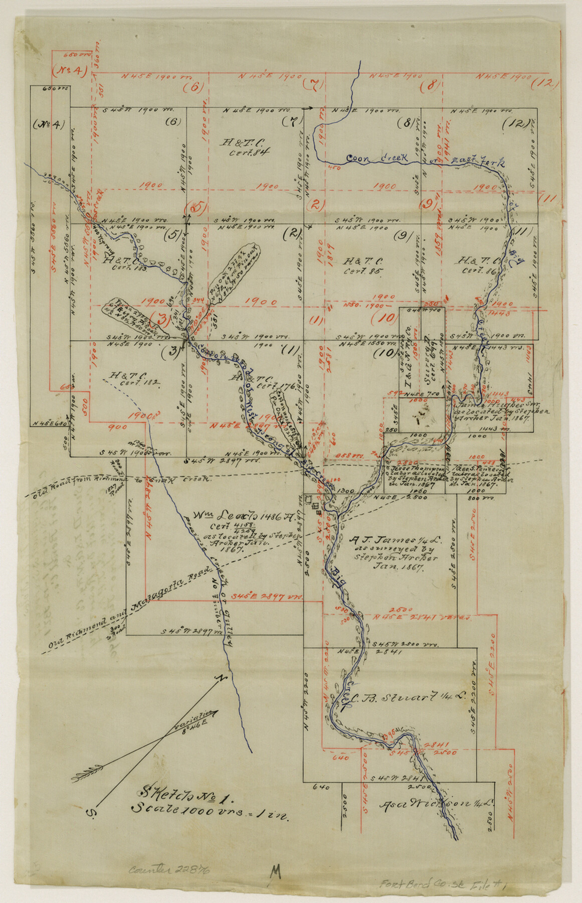
Fort Bend County Sketch File 1
[Two sketches in eastern part of the county]
-
Map/Doc
22876
-
Collection
General Map Collection
-
Object Dates
1873/11/15 (File Date)
-
Counties
Fort Bend
-
Subjects
Surveying Sketch File
-
Height x Width
14.7 x 9.5 inches
37.3 x 24.1 cm
-
Medium
paper, manuscript
-
Scale
1" = 1000 varas
-
Features
Coon Creek
East Fork of Big Creek
Cottonwood Creek
West Prong of Big Creek
Prairie Creek
Old Road from Richmond to Snak [sic] Creek
Old Richmond and Matagorta [sic] Road
Big Creek
Part of: General Map Collection
Trinity County Sketch File 9

Print $41.00
- Digital $50.00
Trinity County Sketch File 9
Size 8.5 x 7.8 inches
Map/Doc 38516
Irion County Boundary File 4

Print $23.00
- Digital $50.00
Irion County Boundary File 4
Size 11.2 x 8.8 inches
Map/Doc 55350
Hockley County Sketch File M

Print $20.00
- Digital $50.00
Hockley County Sketch File M
Size 22.2 x 25.8 inches
Map/Doc 11777
Lipscomb County

Print $20.00
- Digital $50.00
Lipscomb County
1932
Size 40.2 x 37.1 inches
Map/Doc 77355
Reagan County Working Sketch 14b

Print $20.00
- Digital $50.00
Reagan County Working Sketch 14b
Size 20.3 x 9.0 inches
Map/Doc 71855
Stonewall County Working Sketch 16

Print $20.00
- Digital $50.00
Stonewall County Working Sketch 16
1954
Size 39.2 x 29.7 inches
Map/Doc 62323
Map of the West Indies engraved to illustrate Mitchell's new intermediate geography

Print $20.00
- Digital $50.00
Map of the West Indies engraved to illustrate Mitchell's new intermediate geography
1885
Size 9.0 x 12.2 inches
Map/Doc 93524
Henderson County Sketch File 15

Print $4.00
- Digital $50.00
Henderson County Sketch File 15
1890
Size 8.1 x 13.1 inches
Map/Doc 26357
Glasscock County Rolled Sketch 10

Print $20.00
- Digital $50.00
Glasscock County Rolled Sketch 10
Size 47.6 x 45.9 inches
Map/Doc 9058
Medina County Working Sketch 13

Print $20.00
- Digital $50.00
Medina County Working Sketch 13
1972
Size 31.5 x 39.0 inches
Map/Doc 70928
Morris County Boundary File 1

Print $18.00
- Digital $50.00
Morris County Boundary File 1
Size 14.1 x 8.7 inches
Map/Doc 57473
Dallam County Sketch File 2

Print $260.00
- Digital $50.00
Dallam County Sketch File 2
1886
Size 29.9 x 17.4 inches
Map/Doc 11278
You may also like
Flight Mission No. DQN-2K, Frame 89, Calhoun County

Print $20.00
- Digital $50.00
Flight Mission No. DQN-2K, Frame 89, Calhoun County
1953
Size 16.2 x 15.7 inches
Map/Doc 84279
Tahoka Consolidated Independent School District

Print $20.00
- Digital $50.00
Tahoka Consolidated Independent School District
Size 34.1 x 22.1 inches
Map/Doc 92943
[Blocks 47, Z, XO2, M18, M23, M25, and H]
![91236, [Blocks 47, Z, XO2, M18, M23, M25, and H], Twichell Survey Records](https://historictexasmaps.com/wmedia_w700/maps/91236-1.tif.jpg)
Print $20.00
- Digital $50.00
[Blocks 47, Z, XO2, M18, M23, M25, and H]
Size 29.6 x 23.6 inches
Map/Doc 91236
East Portion of Matagorda Bay in Matagorda County, showing Subdivision for Mineral Development

Print $40.00
- Digital $50.00
East Portion of Matagorda Bay in Matagorda County, showing Subdivision for Mineral Development
1949
Size 30.8 x 51.1 inches
Map/Doc 1909
Coast Chart No. 210 - Aransas Pass and Corpus Christi Bay with the coast to latitude 27° 12', Texas

Print $20.00
- Digital $50.00
Coast Chart No. 210 - Aransas Pass and Corpus Christi Bay with the coast to latitude 27° 12', Texas
1887
Size 23.4 x 29.4 inches
Map/Doc 73443
Orange County Working Sketch 38

Print $20.00
- Digital $50.00
Orange County Working Sketch 38
1964
Size 25.4 x 27.7 inches
Map/Doc 71370
Flight Mission No. CLL-1N, Frame 39, Willacy County

Print $20.00
- Digital $50.00
Flight Mission No. CLL-1N, Frame 39, Willacy County
1954
Size 18.4 x 22.0 inches
Map/Doc 87020
Tarrant County Boundary File 2

Print $6.00
- Digital $50.00
Tarrant County Boundary File 2
Size 14.4 x 9.0 inches
Map/Doc 59111
Mills County Sketch File 18A

Print $20.00
- Digital $50.00
Mills County Sketch File 18A
1913
Size 26.5 x 18.4 inches
Map/Doc 12093
Current Miscellaneous File 72

Print $40.00
- Digital $50.00
Current Miscellaneous File 72
Size 10.8 x 8.2 inches
Map/Doc 74159
[Map to illustrate possible mineral resources on the lands belonging to the University of Texas]
![62963, [Map to illustrate possible mineral resources on the lands belonging to the University of Texas], General Map Collection](https://historictexasmaps.com/wmedia_w700/maps/62963.tif.jpg)
Print $2.00
- Digital $50.00
[Map to illustrate possible mineral resources on the lands belonging to the University of Texas]
Size 10.2 x 7.7 inches
Map/Doc 62963
Dimmit County Working Sketch 15

Print $20.00
- Digital $50.00
Dimmit County Working Sketch 15
1942
Size 19.0 x 34.5 inches
Map/Doc 68676