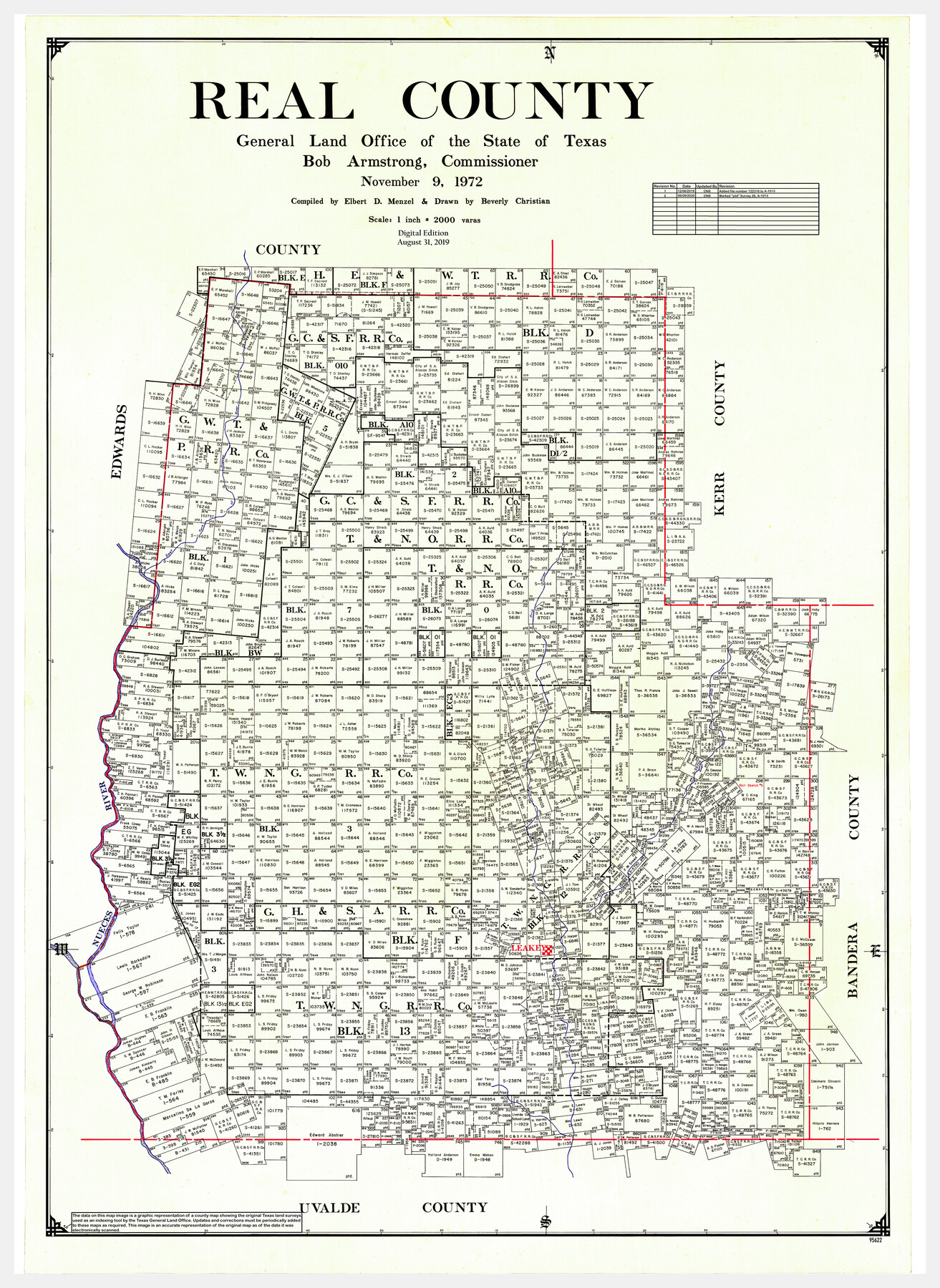
Real County
General Land Office Official County Map
-
Map/Doc
95622
-
Collection
General Map Collection
-
Object Dates
8/31/2019 (Revision Date)
11/9/1972 (Creation Date)
12/6/2019 (Revision Date)
6/9/2020 (Revision Date)
-
People and Organizations
Cheyenne Betancourt (Draftsman)
Beverly Christian (Draftsman)
Bob Armstrong (GLO Commissioner)
Elbert Menzel (Compiler)
-
Counties
Real
-
Subjects
County OCM
-
Height x Width
45.4 x 33.1 inches
115.3 x 84.1 cm
-
Medium
digital image
-
Scale
1" = 2000 varas
Part of: General Map Collection
Kinney County Working Sketch 29

Print $20.00
- Digital $50.00
Kinney County Working Sketch 29
1959
Size 37.8 x 33.8 inches
Map/Doc 70211
Ochiltree County

Print $20.00
- Digital $50.00
Ochiltree County
1889
Size 23.1 x 19.5 inches
Map/Doc 3923
Nueces County Rolled Sketch 93

Print $161.00
Nueces County Rolled Sketch 93
1983
Size 37.3 x 24.2 inches
Map/Doc 7029
Flight Mission No. BRA-3M, Frame 128, Jefferson County

Print $20.00
- Digital $50.00
Flight Mission No. BRA-3M, Frame 128, Jefferson County
1953
Size 18.5 x 22.3 inches
Map/Doc 85402
Frio County Sketch File 15

Print $6.00
- Digital $50.00
Frio County Sketch File 15
1949
Size 11.3 x 8.8 inches
Map/Doc 23145
Duval County Working Sketch 23

Print $20.00
- Digital $50.00
Duval County Working Sketch 23
1943
Size 41.8 x 37.8 inches
Map/Doc 68747
Edwards County Sketch File 19

Print $20.00
- Digital $50.00
Edwards County Sketch File 19
Size 17.1 x 23.7 inches
Map/Doc 11430
Brewster County Rolled Sketch 86

Print $20.00
- Digital $50.00
Brewster County Rolled Sketch 86
1940
Size 16.1 x 26.4 inches
Map/Doc 5247
Brewster County Sketch File 53

Print $94.00
- Digital $50.00
Brewster County Sketch File 53
1910
Size 13.3 x 8.9 inches
Map/Doc 16361
Coleman County Sketch File 19

Print $4.00
- Digital $50.00
Coleman County Sketch File 19
Size 12.5 x 8.1 inches
Map/Doc 18692
Webb County Rolled Sketch 11

Print $20.00
- Digital $50.00
Webb County Rolled Sketch 11
1911
Size 37.1 x 34.7 inches
Map/Doc 10118
Crockett County Rolled Sketch CRV

Print $40.00
- Digital $50.00
Crockett County Rolled Sketch CRV
1925
Size 35.8 x 52.3 inches
Map/Doc 8693
You may also like
Lampasas County

Print $20.00
- Digital $50.00
Lampasas County
1972
Size 33.2 x 41.9 inches
Map/Doc 77347
General Highway Map, Victoria County, Texas

Print $20.00
General Highway Map, Victoria County, Texas
1940
Size 24.8 x 18.5 inches
Map/Doc 79268
Hockley City Located on Labors 7, 8, 13, and 14 of Hood County School League Number 28 Situated in Hockley County, Texas

Print $20.00
- Digital $50.00
Hockley City Located on Labors 7, 8, 13, and 14 of Hood County School League Number 28 Situated in Hockley County, Texas
Size 24.2 x 30.8 inches
Map/Doc 92239
Hunt County Sketch File 40

Print $4.00
- Digital $50.00
Hunt County Sketch File 40
Size 7.6 x 8.0 inches
Map/Doc 27163
Montgomery County Rolled Sketch 41

Print $20.00
- Digital $50.00
Montgomery County Rolled Sketch 41
1975
Size 35.2 x 26.8 inches
Map/Doc 6814
[Points along west and north lines of county]
![90401, [Points along west and north lines of county], Twichell Survey Records](https://historictexasmaps.com/wmedia_w700/maps/90401-1.tif.jpg)
Print $20.00
- Digital $50.00
[Points along west and north lines of county]
Size 14.7 x 19.3 inches
Map/Doc 90401
Kent County Sketch File 12

Print $20.00
- Digital $50.00
Kent County Sketch File 12
1911
Size 26.8 x 23.6 inches
Map/Doc 11916
[Sketch of surveys north of "Las Animas" grant, Webb County]
![668, [Sketch of surveys north of "Las Animas" grant, Webb County], Maddox Collection](https://historictexasmaps.com/wmedia_w700/maps/668.tif.jpg)
Print $3.00
- Digital $50.00
[Sketch of surveys north of "Las Animas" grant, Webb County]
1908
Size 16.9 x 10.7 inches
Map/Doc 668
Webb County Sketch File 6

Print $5.00
- Digital $50.00
Webb County Sketch File 6
1875
Size 7.3 x 13.7 inches
Map/Doc 39735
Presidio County Sketch File 36

Print $10.00
- Digital $50.00
Presidio County Sketch File 36
1908
Size 10.4 x 8.2 inches
Map/Doc 34486
Tom Green County Working Sketch Graphic Index

Print $40.00
- Digital $50.00
Tom Green County Working Sketch Graphic Index
1942
Size 70.9 x 40.1 inches
Map/Doc 76715
Red River County Working Sketch 20

Print $20.00
- Digital $50.00
Red River County Working Sketch 20
1955
Size 26.2 x 25.9 inches
Map/Doc 72003