Frio County Sketch File 15
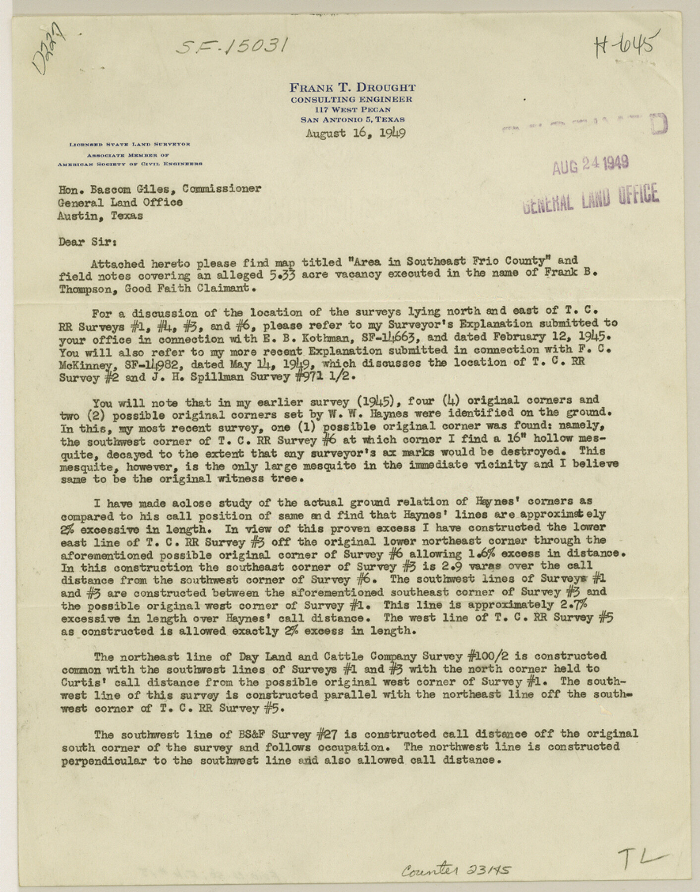
[Surveyor's report regarding SF-15031]
-
Map/Doc
23145
-
Collection
General Map Collection
-
Object Dates
1949/8/16 (Creation Date)
1949/9/3 (File Date)
-
People and Organizations
Frank T. Drought (Surveyor/Engineer)
W.W. Haynes (Surveyor/Engineer)
Hickey (Surveyor/Engineer)
A.L. Curtis (Surveyor/Engineer)
-
Counties
Frio
-
Subjects
Surveying Sketch File
-
Height x Width
11.3 x 8.8 inches
28.7 x 22.4 cm
-
Medium
paper, print
-
Comments
See Frio County Rolled Sketch 14 (5921) for sketch.
Related maps
Frio County Rolled Sketch 14

Print $20.00
- Digital $50.00
Frio County Rolled Sketch 14
1949
Size 25.3 x 32.9 inches
Map/Doc 5921
Part of: General Map Collection

Flight Mission No. DCL-6C, Frame 68, Kenedy County

Print $20.00
- Digital $50.00
Flight Mission No. DCL-6C, Frame 68, Kenedy County
1943
Size 18.6 x 22.4 inches
Map/Doc 85910
Waller County Working Sketch 6

Print $20.00
- Digital $50.00
Waller County Working Sketch 6
1988
Size 31.1 x 20.0 inches
Map/Doc 72305
Culberson County Working Sketch 40

Print $40.00
- Digital $50.00
Culberson County Working Sketch 40
1966
Size 35.5 x 60.9 inches
Map/Doc 68493
Archer County Sketch File 26

Print $4.00
- Digital $50.00
Archer County Sketch File 26
1934
Size 9.7 x 4.4 inches
Map/Doc 13663
Flight Mission No. CGI-3N, Frame 145, Cameron County

Print $20.00
- Digital $50.00
Flight Mission No. CGI-3N, Frame 145, Cameron County
1954
Size 18.6 x 22.3 inches
Map/Doc 84618

Shackelford County Boundary File 7a

Print $9.00
- Digital $50.00
Shackelford County Boundary File 7a
Size 14.9 x 9.4 inches
Map/Doc 58689
Leon County Working Sketch 53

Print $20.00
- Digital $50.00
Leon County Working Sketch 53
1982
Size 22.3 x 25.4 inches
Map/Doc 70453
Presidio County Working Sketch 19

Print $20.00
- Digital $50.00
Presidio County Working Sketch 19
1943
Size 32.9 x 40.3 inches
Map/Doc 71695
Loving County Working Sketch 12

Print $40.00
- Digital $50.00
Loving County Working Sketch 12
1957
Size 48.1 x 37.1 inches
Map/Doc 70645
Edwards County Rolled Sketch 37

Print $20.00
- Digital $50.00
Edwards County Rolled Sketch 37
2018
Size 23.3 x 30.2 inches
Map/Doc 94459
You may also like
[Knox County Blk. 44, H&TC]
![89463, [Knox County Blk. 44, H&TC], Barnes Railroad Collection](https://historictexasmaps.com/wmedia_w700/pdf_converted_jpg/qi_pdf_thumbnail_34701.jpg)
Print $42.00
- Digital $50.00
[Knox County Blk. 44, H&TC]
1892
Size 20.7 x 21.9 inches
Map/Doc 89463
Flight Mission No. CLL-1N, Frame 31, Willacy County

Print $20.00
- Digital $50.00
Flight Mission No. CLL-1N, Frame 31, Willacy County
1954
Size 18.5 x 22.2 inches
Map/Doc 87012
Terrell County Working Sketch 31

Print $20.00
- Digital $50.00
Terrell County Working Sketch 31
1945
Size 26.8 x 27.8 inches
Map/Doc 62123
Flight Mission No. DIX-5P, Frame 109, Aransas County

Print $20.00
- Digital $50.00
Flight Mission No. DIX-5P, Frame 109, Aransas County
1956
Size 17.8 x 18.1 inches
Map/Doc 83788
Reagan County Boundary File 1c

Print $56.00
- Digital $50.00
Reagan County Boundary File 1c
Size 9.2 x 8.2 inches
Map/Doc 58171
Aransas County Aerial Photograph Index Sheet 4

Print $20.00
- Digital $50.00
Aransas County Aerial Photograph Index Sheet 4
1957
Size 23.6 x 16.1 inches
Map/Doc 83662
Map of Bexar County

Print $20.00
- Digital $50.00
Map of Bexar County
1845
Size 47.5 x 41.7 inches
Map/Doc 87235
Lynn County Boundary File 10

Print $110.00
- Digital $50.00
Lynn County Boundary File 10
Size 14.3 x 8.7 inches
Map/Doc 56709
Flight Mission No. BRA-8M, Frame 128, Jefferson County

Print $20.00
- Digital $50.00
Flight Mission No. BRA-8M, Frame 128, Jefferson County
1953
Size 18.6 x 22.3 inches
Map/Doc 85624
Milam County Working Sketch 7

Print $40.00
- Digital $50.00
Milam County Working Sketch 7
1969
Size 42.7 x 48.0 inches
Map/Doc 71022
Cochran County

Print $20.00
- Digital $50.00
Cochran County
1913
Size 29.1 x 20.0 inches
Map/Doc 4743
Flight Mission No. CRC-2R, Frame 109, Chambers County

Print $20.00
- Digital $50.00
Flight Mission No. CRC-2R, Frame 109, Chambers County
1956
Size 18.6 x 22.3 inches
Map/Doc 84736