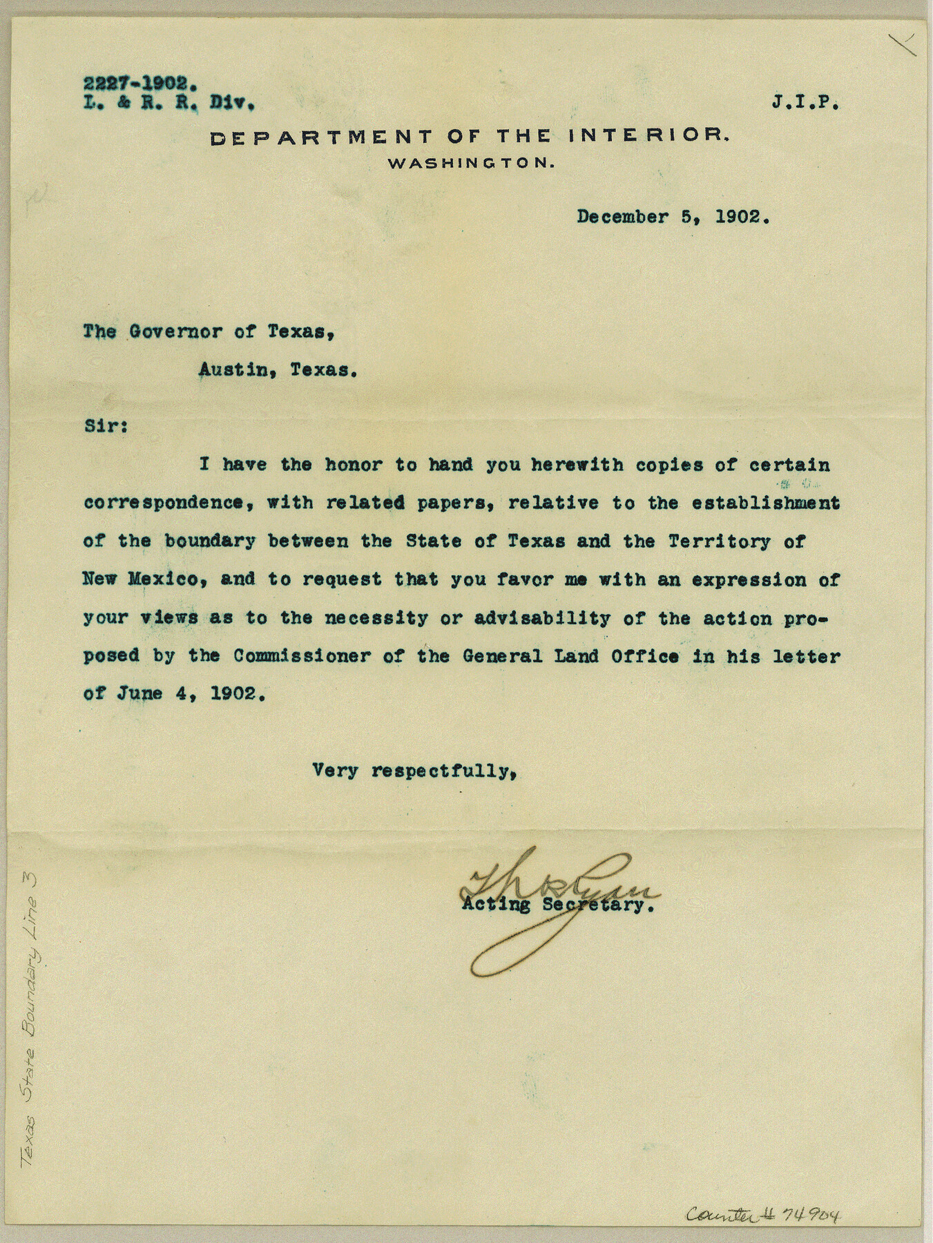
Texas State Boundary Line 3
Letters, reports and statements regarding the Texas-New Mexico boundary line
-
Map/Doc
74904
-
Collection
General Map Collection
-
Subjects
Texas Boundaries
-
Height x Width
10.9 x 8.2 inches
27.7 x 20.8 cm
Part of: General Map Collection
Texas Department of Corrections Prison Unit Locations

Print $20.00
- Digital $50.00
Texas Department of Corrections Prison Unit Locations
1960
Size 37.0 x 45.7 inches
Map/Doc 3104
Flight Mission No. BRE-1P, Frame 31, Nueces County

Print $20.00
- Digital $50.00
Flight Mission No. BRE-1P, Frame 31, Nueces County
1956
Size 18.0 x 21.6 inches
Map/Doc 86627
Upton County Sketch File 24

Print $4.00
- Digital $50.00
Upton County Sketch File 24
1928
Size 11.3 x 8.8 inches
Map/Doc 38879
Flight Mission No. DQN-2K, Frame 118, Calhoun County

Print $20.00
- Digital $50.00
Flight Mission No. DQN-2K, Frame 118, Calhoun County
1953
Size 18.5 x 22.2 inches
Map/Doc 84294
Crosby County Boundary File 1a

Print $32.00
- Digital $50.00
Crosby County Boundary File 1a
Size 12.8 x 8.1 inches
Map/Doc 51981

Guadalupe County Rolled Sketch 1

Print $20.00
- Digital $50.00
Guadalupe County Rolled Sketch 1
1954
Size 33.1 x 38.8 inches
Map/Doc 6044
Hidalgo County

Print $20.00
- Digital $50.00
Hidalgo County
1863
Size 46.0 x 25.2 inches
Map/Doc 3668
Brewster County Working Sketch 104

Print $20.00
- Digital $50.00
Brewster County Working Sketch 104
1980
Size 30.6 x 46.0 inches
Map/Doc 67704
Cooke County Boundary File 3

Print $4.00
- Digital $50.00
Cooke County Boundary File 3
Size 7.3 x 8.7 inches
Map/Doc 51853
Denton County Rolled Sketch 7

Print $20.00
- Digital $50.00
Denton County Rolled Sketch 7
2007
Size 24.5 x 19.3 inches
Map/Doc 87941
Edwards County Working Sketch 100

Print $20.00
- Digital $50.00
Edwards County Working Sketch 100
1971
Size 31.5 x 34.2 inches
Map/Doc 68976
You may also like
[Surveys on the Neches River]
![220, [Surveys on the Neches River], General Map Collection](https://historictexasmaps.com/wmedia_w700/maps/220.tif.jpg)
Print $2.00
- Digital $50.00
[Surveys on the Neches River]
1845
Size 6.0 x 3.8 inches
Map/Doc 220
Caldwell County Sketch File 1

Print $22.00
- Digital $50.00
Caldwell County Sketch File 1
Size 8.6 x 12.4 inches
Map/Doc 35825
Flight Mission No. CUG-3P, Frame 169, Kleberg County

Print $20.00
- Digital $50.00
Flight Mission No. CUG-3P, Frame 169, Kleberg County
1956
Size 18.5 x 22.2 inches
Map/Doc 86289
Montgomery County Boundary File 1

Print $4.00
- Digital $50.00
Montgomery County Boundary File 1
Size 5.8 x 5.5 inches
Map/Doc 57446
Wise County Working Sketch 17

Print $20.00
- Digital $50.00
Wise County Working Sketch 17
1972
Size 29.9 x 25.0 inches
Map/Doc 72631
Coast Chart No. 212 - From Latitude 26° 33' to the Rio Grande Texas

Print $20.00
- Digital $50.00
Coast Chart No. 212 - From Latitude 26° 33' to the Rio Grande Texas
1886
Size 27.4 x 18.2 inches
Map/Doc 72829
Pecos County Rolled Sketch 113

Print $20.00
- Digital $50.00
Pecos County Rolled Sketch 113
1942
Size 31.9 x 35.4 inches
Map/Doc 9721
Bandera County Rolled Sketch 6

Print $40.00
- Digital $50.00
Bandera County Rolled Sketch 6
Size 55.8 x 41.1 inches
Map/Doc 8439
[Mrs. May Vinson Survey]
![91875, [Mrs. May Vinson Survey], Twichell Survey Records](https://historictexasmaps.com/wmedia_w700/maps/91875-1.tif.jpg)
Print $20.00
- Digital $50.00
[Mrs. May Vinson Survey]
Size 25.2 x 14.8 inches
Map/Doc 91875
Flight Mission No. BRA-8M, Frame 68, Jefferson County

Print $20.00
- Digital $50.00
Flight Mission No. BRA-8M, Frame 68, Jefferson County
1953
Size 18.6 x 22.4 inches
Map/Doc 85588
Jasper County Sketch File 27

Print $22.00
- Digital $50.00
Jasper County Sketch File 27
Size 11.4 x 8.8 inches
Map/Doc 27842
Duval County Rolled Sketch 44

Print $20.00
- Digital $50.00
Duval County Rolled Sketch 44
Size 21.2 x 26.5 inches
Map/Doc 8822