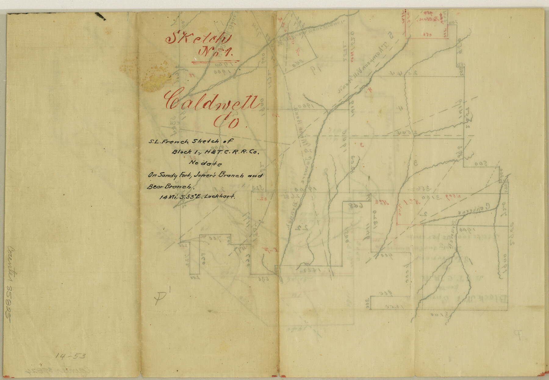
Caldwell County Sketch File 1
Block No. 1 surveyed for the H. & T. C. R.R. Co.
-
Map/Doc
35825
-
Collection
General Map Collection
-
People and Organizations
S.L. French (Surveyor/Engineer)
-
Counties
Caldwell
-
Subjects
Surveying Sketch File
-
Height x Width
8.6 x 12.4 inches
21.8 x 31.5 cm
-
Medium
paper, manuscript
-
Scale
1" = 1000 varas
-
Features
Sand Branch
East Fork Bear Branch
West Fork Bear Branch
Mina Road
Jourers Branch
Copperas Branch
Thompson Vill Road
Part of: General Map Collection
[Shelby District]
![69740, [Shelby District], General Map Collection](https://historictexasmaps.com/wmedia_w700/maps/69740.tif.jpg)
Print $2.00
- Digital $50.00
[Shelby District]
1845
Size 6.9 x 7.6 inches
Map/Doc 69740
Highland Lakes of Central Texas

Print $20.00
- Digital $50.00
Highland Lakes of Central Texas
1947
Size 18.2 x 21.9 inches
Map/Doc 60291
Liberty County Working Sketch 58

Print $40.00
- Digital $50.00
Liberty County Working Sketch 58
1968
Size 37.3 x 70.3 inches
Map/Doc 70518
Fractional Township No. 8 South Range No. 13 East of the Indian Meridian, Indian Territory

Print $20.00
- Digital $50.00
Fractional Township No. 8 South Range No. 13 East of the Indian Meridian, Indian Territory
1896
Size 19.1 x 24.3 inches
Map/Doc 75224
Milam County Working Sketch 6

Print $20.00
- Digital $50.00
Milam County Working Sketch 6
1963
Size 29.1 x 23.9 inches
Map/Doc 71021
Crosby County Sketch File 22

Print $22.00
- Digital $50.00
Crosby County Sketch File 22
1912
Size 11.3 x 8.6 inches
Map/Doc 20090
Map of Stephens County

Print $20.00
- Digital $50.00
Map of Stephens County
1879
Size 24.0 x 19.6 inches
Map/Doc 4053
Johnson County Sketch File 5

Print $20.00
- Digital $50.00
Johnson County Sketch File 5
1874
Size 33.3 x 14.3 inches
Map/Doc 11890
Starr County Working Sketch 8

Print $20.00
- Digital $50.00
Starr County Working Sketch 8
1939
Size 21.9 x 28.8 inches
Map/Doc 63924
Pecos County Working Sketch 134

Print $40.00
- Digital $50.00
Pecos County Working Sketch 134
1979
Size 53.3 x 37.3 inches
Map/Doc 71608
Presidio County Working Sketch 91

Print $40.00
- Digital $50.00
Presidio County Working Sketch 91
1974
Size 42.0 x 59.4 inches
Map/Doc 71768
Flight Mission No. DQN-7K, Frame 33, Calhoun County

Print $20.00
- Digital $50.00
Flight Mission No. DQN-7K, Frame 33, Calhoun County
1953
Size 18.5 x 22.1 inches
Map/Doc 84471
You may also like
Mitchell County Working Sketch 4

Print $20.00
- Digital $50.00
Mitchell County Working Sketch 4
1926
Size 28.5 x 31.5 inches
Map/Doc 71061
Bailey County Sketch File 15

Print $18.00
- Digital $50.00
Bailey County Sketch File 15
1912
Size 8.7 x 11.2 inches
Map/Doc 13975
Jeff Davis County Rolled Sketch 28

Print $20.00
- Digital $50.00
Jeff Davis County Rolled Sketch 28
1977
Size 41.0 x 30.5 inches
Map/Doc 6376
Newton County

Print $40.00
- Digital $50.00
Newton County
1946
Size 48.7 x 42.6 inches
Map/Doc 73250
Hudspeth County Working Sketch 29

Print $40.00
- Digital $50.00
Hudspeth County Working Sketch 29
1972
Size 31.5 x 55.2 inches
Map/Doc 66311
Reeves County Working Sketch 23

Print $40.00
- Digital $50.00
Reeves County Working Sketch 23
1966
Size 31.6 x 54.5 inches
Map/Doc 63466
Dimmit County Working Sketch 52

Print $20.00
- Digital $50.00
Dimmit County Working Sketch 52
1989
Size 25.2 x 37.0 inches
Map/Doc 68713
Crockett County Sketch File 4a

Print $20.00
- Digital $50.00
Crockett County Sketch File 4a
Size 28.1 x 8.2 inches
Map/Doc 11215
General Highway Map, Borden County, Texas

Print $20.00
General Highway Map, Borden County, Texas
1940
Size 18.5 x 25.0 inches
Map/Doc 79021

McMullen County Sketch File 11

Print $4.00
- Digital $50.00
McMullen County Sketch File 11
1876
Size 7.3 x 8.4 inches
Map/Doc 31355
George M. Boles' Ranch Lands

Print $20.00
- Digital $50.00
George M. Boles' Ranch Lands
1935
Size 31.0 x 24.9 inches
Map/Doc 92862