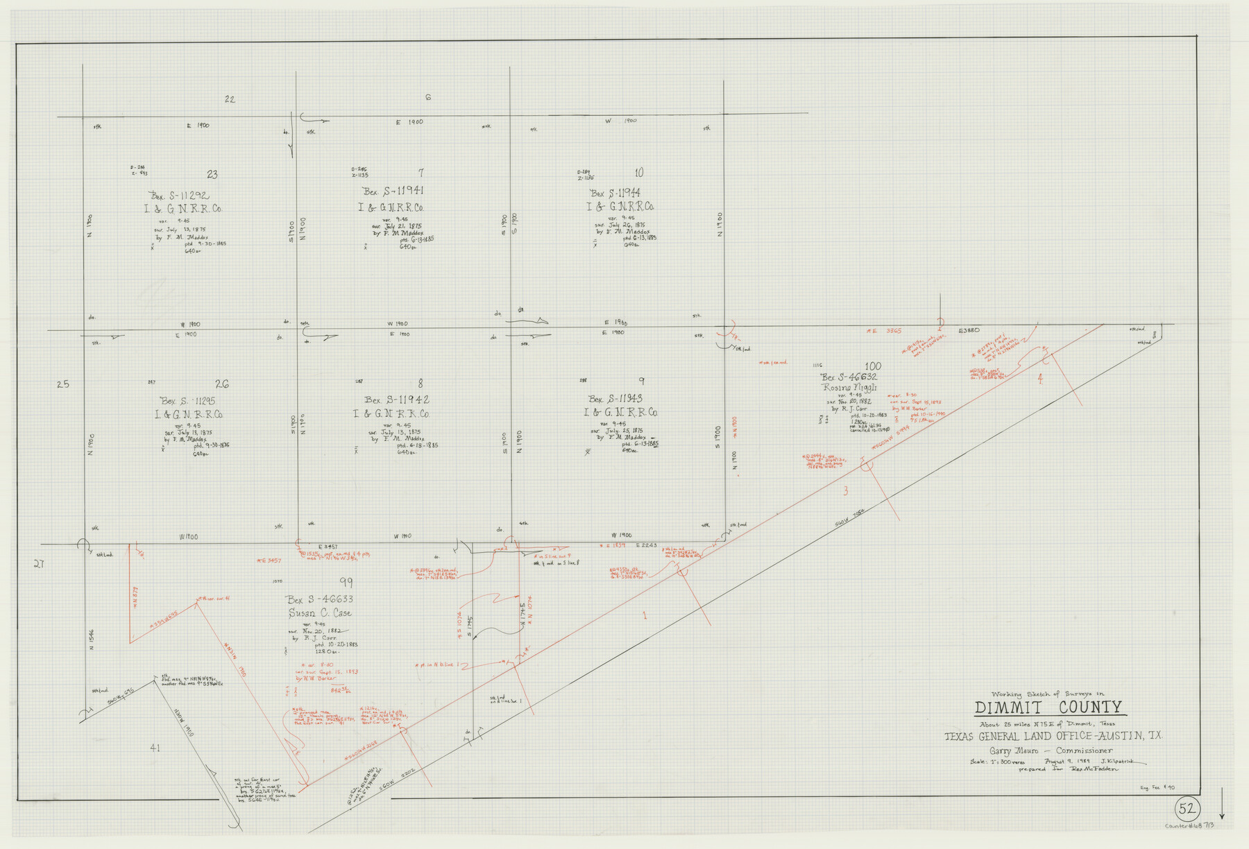
Dimmit County Working Sketch 52
- 
                          Map/Doc68713
- 
                            CollectionGeneral Map Collection
- 
                            Object Dates8/9/1989 (Creation Date)
- 
                            People and OrganizationsJoan Kilpatrick (Draftsman)
- 
                            CountiesDimmit
- 
                            SubjectsSurveying Working Sketch
- 
                            Height x Width25.2 x 37.0 inches64.0 x 94.0 cm
- 
                            Scale1" = 300 varas
Part of: General Map Collection
            Brewster County Rolled Sketch 24C


                                            Print $20.00                    
                                             -                         Digital $50.00                                    
                Brewster County Rolled Sketch 24C
Size 17.5 x 20.8 inches
                                Map/Doc 5210
            
            Upton County Working Sketch 5


                                            Print $20.00                    
                                             -                         Digital $50.00                                    
                Upton County Working Sketch 5
1909
Size 15.9 x 27.1 inches
                                Map/Doc 69501
            
            Regni Mexicani seu Novae Hispaniae, Ludovicianae, N. Angliae, Carolinae, Virginiae, et Pennsylvaniae


                                            Print $20.00                    
                                             -                         Digital $50.00                                    
                Regni Mexicani seu Novae Hispaniae, Ludovicianae, N. Angliae, Carolinae, Virginiae, et Pennsylvaniae
1720
Size 22.5 x 26.5 inches
                                Map/Doc 93408
            
            Outer Continental Shelf Leasing Maps (Louisiana Offshore Operations)


                                            Print $20.00                    
                                             -                         Digital $50.00                                    
                Outer Continental Shelf Leasing Maps (Louisiana Offshore Operations)
1954
Size 18.2 x 16.0 inches
                                Map/Doc 76105
            
            Map of the Fort Worth & Denver City Railway, Wichita County, Texas


                                            Print $40.00                    
                                             -                         Digital $50.00                                    
                Map of the Fort Worth & Denver City Railway, Wichita County, Texas
1885
Size 23.7 x 66.5 inches
                                Map/Doc 64455
            
            Walker County


                                            Print $20.00                    
                                             -                         Digital $50.00                                    
                Walker County
1944
Size 40.4 x 34.4 inches
                                Map/Doc 77448
            
            Chart of the Harbour of San [Luis]
            
                                    ![72761, Chart of the Harbour of San [Luis], General Map Collection](https://historictexasmaps.com/wmedia_w700/maps/72761.tif.jpg) 


    ![72761, Chart of the Harbour of San [Luis], General Map Collection](https://historictexasmaps.com/wmedia_w700/maps/72761.tif.jpg) 
                                
            
                                            Print $20.00                    
                                             -                         Digital $50.00                                    
                Chart of the Harbour of San [Luis]
1846
Size 27.3 x 18.3 inches
                                Map/Doc 72761
            
            Van Zandt County


                                            Print $20.00                    
                                             -                         Digital $50.00                                    
                Van Zandt County
1870
Size 22.8 x 21.1 inches
                                Map/Doc 4638
            
            Reagan County Sketch File 2B


                                            Print $20.00                    
                                             -                         Digital $50.00                                    
                Reagan County Sketch File 2B
Size 20.4 x 22.2 inches
                                Map/Doc 12212
            
            Intracoastal Waterway - Galveston Bay to West Bay including Galveston Bay Entrance


                                            Print $20.00                    
                                             -                         Digital $50.00                                    
                Intracoastal Waterway - Galveston Bay to West Bay including Galveston Bay Entrance
1962
Size 26.9 x 38.6 inches
                                Map/Doc 69936
            
            Nolan County Sketch File 17


                                            Print $6.00                    
                                             -                         Digital $50.00                                    
                Nolan County Sketch File 17
1940
Size 17.9 x 10.1 inches
                                Map/Doc 32487
            
            Coryell County Working Sketch 26


                                            Print $20.00                    
                                             -                         Digital $50.00                                    
                Coryell County Working Sketch 26
1988
Size 30.7 x 30.6 inches
                                Map/Doc 68233
            You may also like
            Flight Mission No. DAG-24K, Frame 53, Matagorda County


                                            Print $20.00                    
                                             -                         Digital $50.00                                    
                Flight Mission No. DAG-24K, Frame 53, Matagorda County
1953
Size 18.5 x 22.3 inches
                                Map/Doc 86540
            
            Flight Mission No. CRE-1R, Frame 193, Jackson County


                                            Print $20.00                    
                                             -                         Digital $50.00                                    
                Flight Mission No. CRE-1R, Frame 193, Jackson County
1956
Size 18.5 x 22.2 inches
                                Map/Doc 85347
            
            Map showing survey for proposed ship channel from Brownsville to Brazos Santiago Pass


                                            Print $20.00                    
                                             -                         Digital $50.00                                    
                Map showing survey for proposed ship channel from Brownsville to Brazos Santiago Pass
1912
Size 18.6 x 28.8 inches
                                Map/Doc 72901
            
            The Inca, An Empire and its Ancestors


            The Inca, An Empire and its Ancestors
Size 31.2 x 20.4 inches
                                Map/Doc 95936
            
            Map of the Fort Worth & Denver City Railway, Hartley County, Texas


                                            Print $40.00                    
                                             -                         Digital $50.00                                    
                Map of the Fort Worth & Denver City Railway, Hartley County, Texas
1887
Size 21.9 x 89.8 inches
                                Map/Doc 64390
            
            Llano County Sketch File 13


                                            Print $4.00                    
                                             -                         Digital $50.00                                    
                Llano County Sketch File 13
1891
Size 9.2 x 15.3 inches
                                Map/Doc 30387
            
            Brown County State Real Property Sketch 1


                                            Print $80.00                    
                                             -                         Digital $50.00                                    
                Brown County State Real Property Sketch 1
2018
Size 48.0 x 36.0 inches
                                Map/Doc 95204
            
            Flight Mission No. BRE-2P, Frame 10, Nueces County


                                            Print $20.00                    
                                             -                         Digital $50.00                                    
                Flight Mission No. BRE-2P, Frame 10, Nueces County
1956
Size 17.9 x 21.5 inches
                                Map/Doc 86719
            
            Brewster County Rolled Sketch 129


                                            Print $20.00                    
                                             -                         Digital $50.00                                    
                Brewster County Rolled Sketch 129
1978
Size 24.4 x 15.3 inches
                                Map/Doc 5301
            
            [State Capitol Leagues along Bailey-Lamb County Line]
            
                                    ![90163, [State Capitol Leagues along Bailey-Lamb County Line], Twichell Survey Records](https://historictexasmaps.com/wmedia_w700/maps/90163-1.tif.jpg) 


    ![90163, [State Capitol Leagues along Bailey-Lamb County Line], Twichell Survey Records](https://historictexasmaps.com/wmedia_w700/maps/90163-1.tif.jpg) 
                                
            
                                            Print $20.00                    
                                             -                         Digital $50.00                                    
                [State Capitol Leagues along Bailey-Lamb County Line]
Size 20.7 x 21.3 inches
                                Map/Doc 90163
            
            Wichita County


                                            Print $20.00                    
                                             -                         Digital $50.00                                    
                Wichita County
1889
Size 26.8 x 37.4 inches
                                Map/Doc 4144
             
                        ![89854, [Lamesa], Twichell Survey Records](https://historictexasmaps.com/wmedia_w700/maps/89854-1.tif.jpg)