Bandera County Rolled Sketch 6
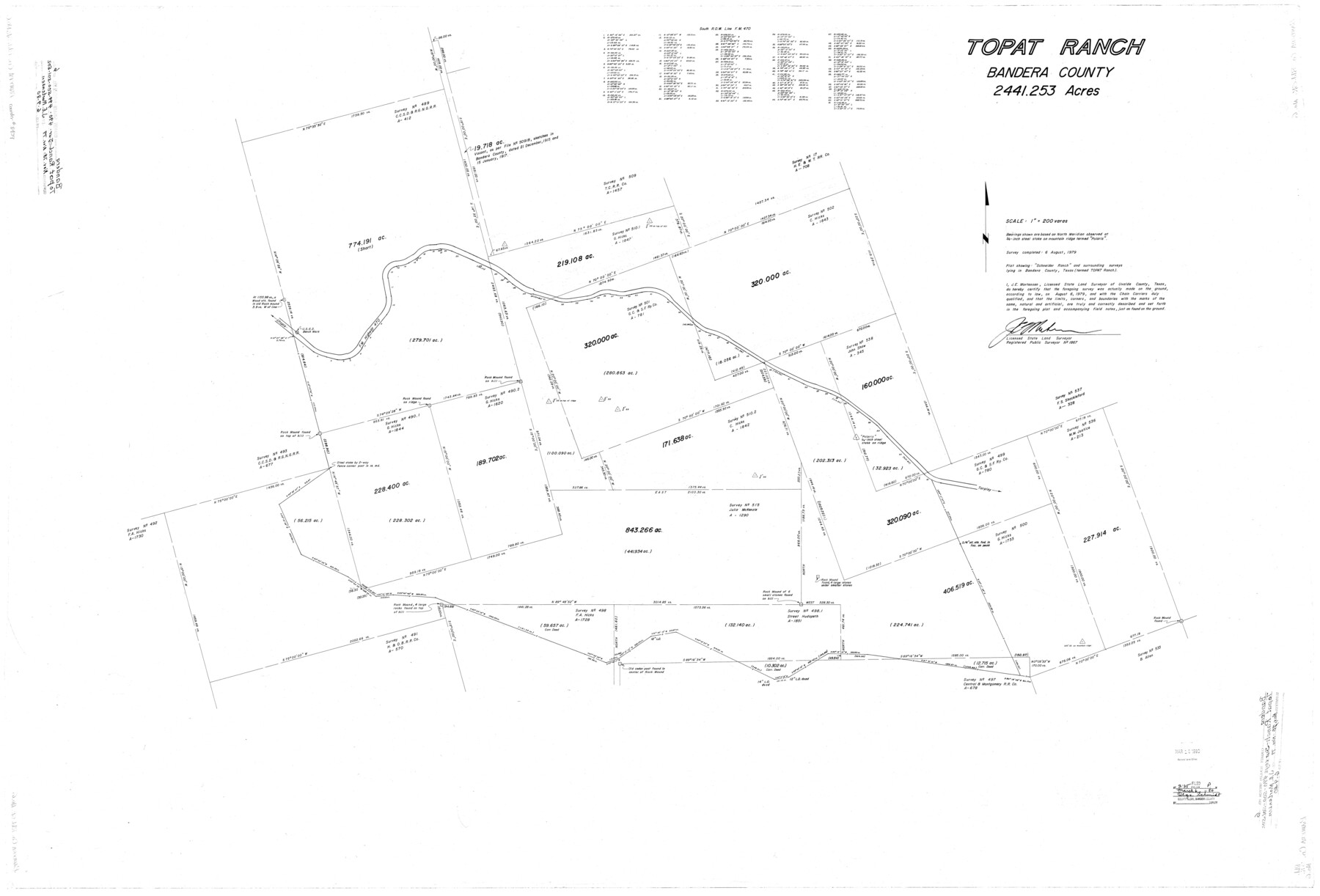
Topat Ranch, Bandera County, 2441.253 acres
-
Map/Doc
8439
-
Collection
General Map Collection
-
Object Dates
1979/8/6 (Survey Date)
1980/6/9 (File Date)
-
People and Organizations
James E. Mortensen (Surveyor/Engineer)
-
Counties
Bandera
-
Subjects
Surveying Rolled Sketch
-
Height x Width
55.8 x 41.1 inches
141.7 x 104.4 cm
-
Medium
linen, manuscript
-
Scale
1" = 200 varas
Part of: General Map Collection
Schleicher County Sketch File 17

Print $20.00
- Digital $50.00
Schleicher County Sketch File 17
Size 23.4 x 17.8 inches
Map/Doc 12299
Val Verde County Working Sketch 3

Print $20.00
- Digital $50.00
Val Verde County Working Sketch 3
Size 17.5 x 24.1 inches
Map/Doc 72138
Atascosa County Sketch File 37

Print $40.00
- Digital $50.00
Atascosa County Sketch File 37
Size 17.6 x 12.9 inches
Map/Doc 13829
Map of Williamson County

Print $20.00
- Digital $50.00
Map of Williamson County
1856
Size 21.8 x 27.6 inches
Map/Doc 4149

Jefferson County Sketch File 53

Print $36.00
- Digital $50.00
Jefferson County Sketch File 53
1973
Size 11.2 x 8.9 inches
Map/Doc 28255
[Sketch for Mineral Application 15559 - Hutchinson County, Canadian River]
![65680, [Sketch for Mineral Application 15559 - Hutchinson County, Canadian River], General Map Collection](https://historictexasmaps.com/wmedia_w700/maps/65680-1.tif.jpg)
Print $20.00
- Digital $50.00
[Sketch for Mineral Application 15559 - Hutchinson County, Canadian River]
1926
Size 12.0 x 13.2 inches
Map/Doc 65680
Sutton County Working Sketch 38

Print $20.00
- Digital $50.00
Sutton County Working Sketch 38
1942
Size 35.2 x 26.1 inches
Map/Doc 62381
Stonewall County Sketch File 18

Print $16.00
- Digital $50.00
Stonewall County Sketch File 18
1902
Size 13.7 x 8.4 inches
Map/Doc 37276
Upton County Rolled Sketch 47

Print $20.00
- Digital $50.00
Upton County Rolled Sketch 47
1937
Size 22.6 x 35.3 inches
Map/Doc 8083
Eastland County Sketch File 10

Print $42.00
- Digital $50.00
Eastland County Sketch File 10
Size 7.0 x 7.8 inches
Map/Doc 21582
Edwards County Working Sketch 49

Print $20.00
- Digital $50.00
Edwards County Working Sketch 49
1950
Size 23.6 x 28.1 inches
Map/Doc 68925
You may also like
Tarrant County Sketch File 30

Print $4.00
- Digital $50.00
Tarrant County Sketch File 30
1882
Size 8.9 x 5.9 inches
Map/Doc 37749

Central & Montgomery

Print $40.00
- Digital $50.00
Central & Montgomery
1941
Size 26.1 x 123.0 inches
Map/Doc 64523
Padre Island National Seashore

Print $4.00
- Digital $50.00
Padre Island National Seashore
Size 16.1 x 22.4 inches
Map/Doc 60541
Map of the United States, the British Provinces, Mexico &c. Showing the Routes of the U.S. Mail Steam Packets to California and a Plan of the Gold Region

Print $20.00
- Digital $50.00
Map of the United States, the British Provinces, Mexico &c. Showing the Routes of the U.S. Mail Steam Packets to California and a Plan of the Gold Region
1849
Size 19.6 x 26.6 inches
Map/Doc 95695
Rockwall County

Print $20.00
- Digital $50.00
Rockwall County
1941
Size 29.7 x 24.1 inches
Map/Doc 95628
Right-of-Way & Track Map, Houston & Brazos Valley Ry. operated by Houston & Brazos Valley Ry.

Print $40.00
- Digital $50.00
Right-of-Way & Track Map, Houston & Brazos Valley Ry. operated by Houston & Brazos Valley Ry.
1918
Size 25.0 x 56.3 inches
Map/Doc 64603
Gulf of Mexico

Print $20.00
- Digital $50.00
Gulf of Mexico
1905
Size 18.3 x 26.8 inches
Map/Doc 72654
Flight Mission No. BRA-7M, Frame 189, Jefferson County

Print $20.00
- Digital $50.00
Flight Mission No. BRA-7M, Frame 189, Jefferson County
1953
Size 18.5 x 22.3 inches
Map/Doc 85557
Young County Sketch File 3

Print $4.00
- Digital $50.00
Young County Sketch File 3
1854
Size 12.3 x 8.2 inches
Map/Doc 40847
Pecos County Rolled Sketch JAS-1

Print $40.00
- Digital $50.00
Pecos County Rolled Sketch JAS-1
1936
Size 41.8 x 63.8 inches
Map/Doc 76146
The First Part of Captn. Pike's Chart of the Internal Part of Louisiana

Print $20.00
- Digital $50.00
The First Part of Captn. Pike's Chart of the Internal Part of Louisiana
1810
Size 19.6 x 21.2 inches
Map/Doc 95154