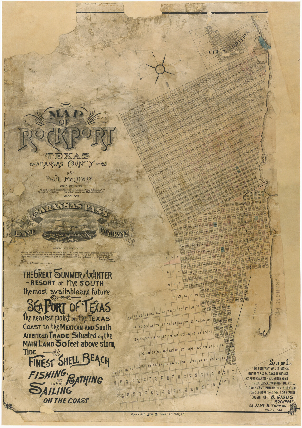
Map of Rockport Texas, Aransas County
- 
                          Map/Doc380
- 
                            CollectionMaddox Collection
- 
                            Object Dates1888 (Creation Date)
- 
                            People and OrganizationsAransas Pass Land Company (Publisher)Dallas Lithography Company (Printer)Paul McCombs (Compiler)Paul McCombs (Draftsman)Paul McCombs (Surveyor/Engineer)
- 
                            CountiesAransas
- 
                            SubjectsCity
- 
                            Height x Width29.0 x 20.5 inches73.7 x 52.1 cm
- 
                            CommentsConservation funded in 2004 with donation from Mr. and Mrs. Casey McManemin in honor of Robert T. Herrin, III.
- 
                            URLshttps://medium.com/save-texas-history/mapping-texas-the-gulf-coast-coastal-cities-5c63b65dea8c#.f78ryao5z
Part of: Maddox Collection
            Map showing the John B. Pier Survey, Near Houston


                                            Print $3.00                    
                                             -                         Digital $50.00                                    
                Map showing the John B. Pier Survey, Near Houston
Size 11.9 x 17.8 inches
                                Map/Doc 478
            
            Map of Kimble County, Texas


                                            Print $20.00                    
                                             -                         Digital $50.00                                    
                Map of Kimble County, Texas
1879
Size 18.1 x 28.3 inches
                                Map/Doc 527
            
            Moore County, Texas


                                            Print $20.00                    
                                             -                         Digital $50.00                                    
                Moore County, Texas
1888
Size 22.0 x 18.3 inches
                                Map/Doc 742
            
            Plat of Ingleside and Garden Tracts


                                            Print $20.00                    
                                             -                         Digital $50.00                                    
                Plat of Ingleside and Garden Tracts
1890
Size 25.4 x 30.4 inches
                                Map/Doc 661
            
            Map of Martinsburg Property, Gillespie Co., Tex.


                                            Print $20.00                    
                                             -                         Digital $50.00                                    
                Map of Martinsburg Property, Gillespie Co., Tex.
Size 15.7 x 13.6 inches
                                Map/Doc 446
            
            Comanche County, Texas


                                            Print $20.00                    
                                             -                         Digital $50.00                                    
                Comanche County, Texas
1879
Size 23.5 x 28.4 inches
                                Map/Doc 702
            
            Sketch of Surveys in Knox, Baylor, Haskell and Throckmorton Ctes


                                            Print $40.00                    
                                             -                         Digital $50.00                                    
                Sketch of Surveys in Knox, Baylor, Haskell and Throckmorton Ctes
1888
Size 43.3 x 58.5 inches
                                Map/Doc 4386
            
            Map of surveys 189 & 190 T. C. R.R. Co. in Travis County, Texas


                                            Print $20.00                    
                                             -                         Digital $50.00                                    
                Map of surveys 189 & 190 T. C. R.R. Co. in Travis County, Texas
1915
Size 16.1 x 24.0 inches
                                Map/Doc 5079
            
            [Surveying sketch of P. Castleman, H. George, et al in Wichita County]
            
                                    ![389, [Surveying sketch of P. Castleman, H. George, et al in Wichita County], Maddox Collection](https://historictexasmaps.com/wmedia_w700/maps/0389-1.tif.jpg) 


    ![389, [Surveying sketch of P. Castleman, H. George, et al in Wichita County], Maddox Collection](https://historictexasmaps.com/wmedia_w700/maps/0389-1.tif.jpg) 
                                
            
                                            Print $20.00                    
                                             -                         Digital $50.00                                    
                [Surveying sketch of P. Castleman, H. George, et al in Wichita County]
Size 12.6 x 24.5 inches
                                Map/Doc 389
            
            [Unknown Building Sketch]
            
                                    ![75794, [Unknown Building Sketch], Maddox Collection](https://historictexasmaps.com/wmedia_w700/maps/75794.tif.jpg) 


    ![75794, [Unknown Building Sketch], Maddox Collection](https://historictexasmaps.com/wmedia_w700/maps/75794.tif.jpg) 
                                
            
                                            Print $20.00                    
                                             -                         Digital $50.00                                    
                [Unknown Building Sketch]
Size 17.1 x 22.6 inches
                                Map/Doc 75794
            
            Map of Bandera County, Texas


                                            Print $20.00                    
                                             -                         Digital $50.00                                    
                Map of Bandera County, Texas
1879
Size 19.6 x 32.6 inches
                                Map/Doc 691
            
            Survey in South Austin for Mr. R.N. Graham


                                            Print $20.00                    
                                             -                         Digital $50.00                                    
                Survey in South Austin for Mr. R.N. Graham
1915
Size 22.6 x 33.8 inches
                                Map/Doc 564
            You may also like
            Flight Mission No. CLL-1N, Frame 32, Willacy County


                                            Print $20.00                    
                                             -                         Digital $50.00                                    
                Flight Mission No. CLL-1N, Frame 32, Willacy County
1954
Size 17.5 x 19.4 inches
                                Map/Doc 87013
            
            Concho County Rolled Sketch 13


                                            Print $20.00                    
                                             -                         Digital $50.00                                    
                Concho County Rolled Sketch 13
1958
Size 23.7 x 20.3 inches
                                Map/Doc 78461
            
            Map of Chicago, Rock Island & Texas Railway through Wise and Tarrant County, Texas


                                            Print $40.00                    
                                             -                         Digital $50.00                                    
                Map of Chicago, Rock Island & Texas Railway through Wise and Tarrant County, Texas
1893
Size 19.4 x 121.0 inches
                                Map/Doc 64428
            
            Baylor County Sketch File 12h


                                            Print $49.00                    
                                             -                         Digital $50.00                                    
                Baylor County Sketch File 12h
Size 9.3 x 14.7 inches
                                Map/Doc 14175
            
            General Highway Map, Loving County, Texas


                                            Print $20.00                    
                                    
                General Highway Map, Loving County, Texas
1940
Size 18.3 x 24.8 inches
                                Map/Doc 79179
            
            Lynn County Working Sketch Graphic Index


                                            Print $20.00                    
                                             -                         Digital $50.00                                    
                Lynn County Working Sketch Graphic Index
1961
Size 38.7 x 35.1 inches
                                Map/Doc 76627
            
            The Republic County of Washington. January 30, 1841


                                            Print $20.00                    
                                    
                The Republic County of Washington. January 30, 1841
2020
Size 20.3 x 21.7 inches
                                Map/Doc 96305
            
            Fort Bend County Working Sketch 4


                                            Print $20.00                    
                                             -                         Digital $50.00                                    
                Fort Bend County Working Sketch 4
1909
Size 23.5 x 34.8 inches
                                Map/Doc 69210
            
            Fisher County Sketch File 11


                                            Print $20.00                    
                                             -                         Digital $50.00                                    
                Fisher County Sketch File 11
Size 22.8 x 20.4 inches
                                Map/Doc 11478
            
            Anderson County Working Sketch 43


                                            Print $20.00                    
                                             -                         Digital $50.00                                    
                Anderson County Working Sketch 43
1988
Size 37.2 x 33.9 inches
                                Map/Doc 67043
            
            Sterling County Sketch File 2


                                            Print $6.00                    
                                             -                         Digital $50.00                                    
                Sterling County Sketch File 2
Size 10.7 x 15.6 inches
                                Map/Doc 37113
             
                        