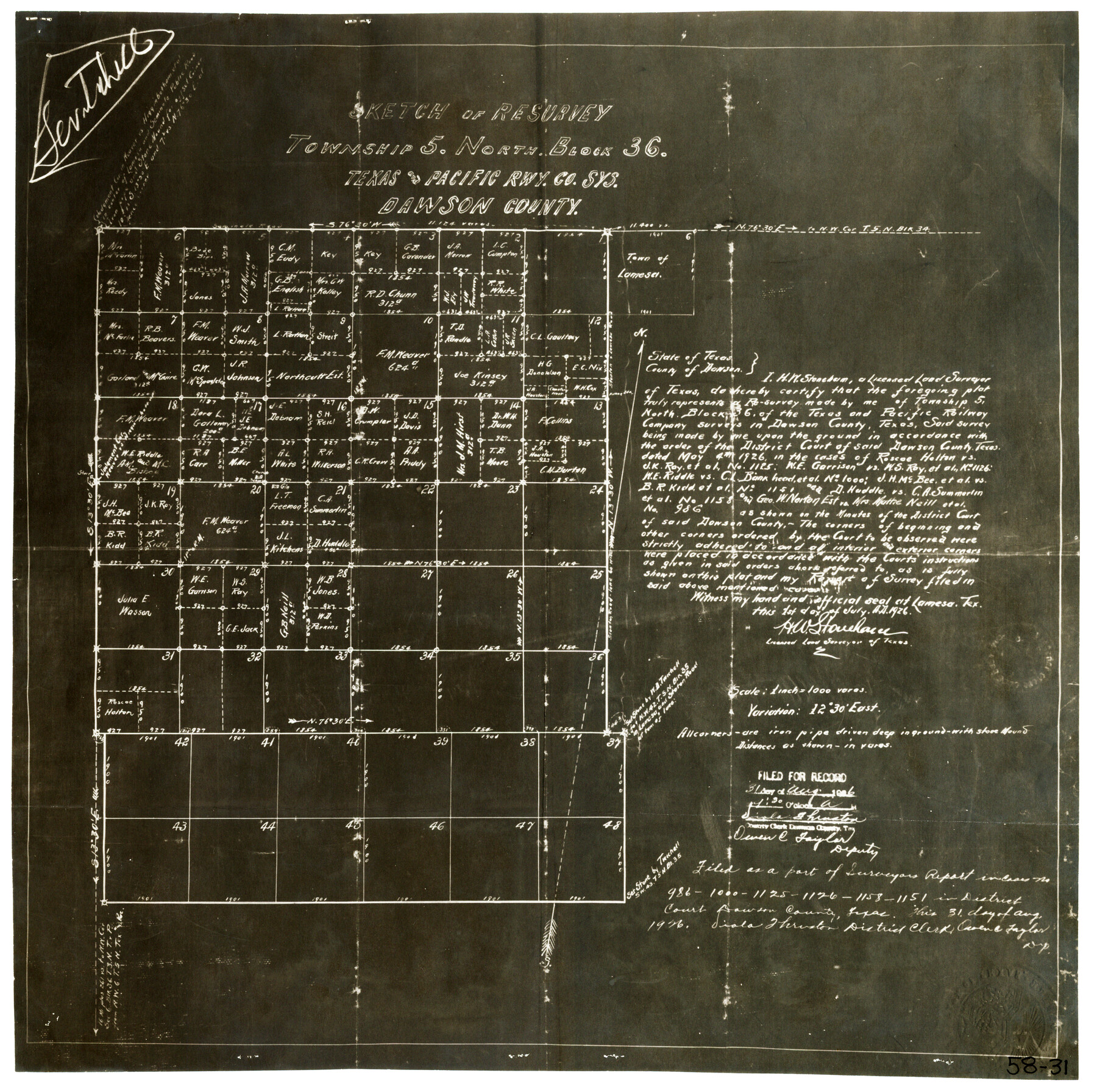
Sketch of Resurvey Township 5 North Block 36, Texas and Pacific Rwy. Co. Sys. Dawson County
58-31
-
Map/Doc
90544
-
Collection
Twichell Survey Records
-
Object Dates
7/1/1926 (Creation Date)
-
People and Organizations
H.W. Stoneham (Surveyor/Engineer)
-
Counties
Dawson
-
Height x Width
12.1 x 12.0 inches
30.7 x 30.5 cm
Part of: Twichell Survey Records
Working Sketch of Surveys in Kent & Scurry Counties Located South of Clairemont, Texas

Print $20.00
- Digital $50.00
Working Sketch of Surveys in Kent & Scurry Counties Located South of Clairemont, Texas
1947
Size 41.2 x 43.4 inches
Map/Doc 89861
[Sketch from Paul McCombs Map of 1884, showing T. & P. Township 5, Block 60, Township 6, Block 59, and Township 7, Blocks 59 and 60]
![91774, [Sketch from Paul McCombs Map of 1884, showing T. & P. Township 5, Block 60, Township 6, Block 59, and Township 7, Blocks 59 and 60], Twichell Survey Records](https://historictexasmaps.com/wmedia_w700/maps/91774-1.tif.jpg)
Print $2.00
- Digital $50.00
[Sketch from Paul McCombs Map of 1884, showing T. & P. Township 5, Block 60, Township 6, Block 59, and Township 7, Blocks 59 and 60]
Size 9.2 x 15.0 inches
Map/Doc 91774
Western Cotton Oil Co. Property Lamb County, Texas

Print $20.00
- Digital $50.00
Western Cotton Oil Co. Property Lamb County, Texas
1951
Size 20.9 x 16.9 inches
Map/Doc 92166
Leagues 35, 36, 37, 38, 39, 40, 41, and 42]
![92236, Leagues 35, 36, 37, 38, 39, 40, 41, and 42], Twichell Survey Records](https://historictexasmaps.com/wmedia_w700/maps/92236-1.tif.jpg)
Print $20.00
- Digital $50.00
Leagues 35, 36, 37, 38, 39, 40, 41, and 42]
Size 40.4 x 34.4 inches
Map/Doc 92236
[Sketch showing Blocks 1, 3, 5, K14, 2Z, 7]
![91824, [Sketch showing Blocks 1, 3, 5, K14, 2Z, 7], Twichell Survey Records](https://historictexasmaps.com/wmedia_w700/maps/91824-1.tif.jpg)
Print $20.00
- Digital $50.00
[Sketch showing Blocks 1, 3, 5, K14, 2Z, 7]
Size 23.6 x 20.0 inches
Map/Doc 91824
[Survey 321, Double Lakes Area, Northwest of Tohoka]
![91299, [Survey 321, Double Lakes Area, Northwest of Tohoka], Twichell Survey Records](https://historictexasmaps.com/wmedia_w700/maps/91299-1.tif.jpg)
Print $20.00
- Digital $50.00
[Survey 321, Double Lakes Area, Northwest of Tohoka]
Size 26.9 x 19.5 inches
Map/Doc 91299
[H. & T. C. Blocks 25 and 26]
![92025, [H. & T. C. Blocks 25 and 26], Twichell Survey Records](https://historictexasmaps.com/wmedia_w700/maps/92025-1.tif.jpg)
Print $20.00
- Digital $50.00
[H. & T. C. Blocks 25 and 26]
1873
Size 42.2 x 33.9 inches
Map/Doc 92025
Map of Dalhart

Print $20.00
- Digital $50.00
Map of Dalhart
1905
Size 23.5 x 32.0 inches
Map/Doc 92146
[T. & P. RR. Lands and Surrounding surveys]
![91131, [T. & P. RR. Lands and Surrounding surveys], Twichell Survey Records](https://historictexasmaps.com/wmedia_w700/maps/91131.tif.jpg)
Print $20.00
- Digital $50.00
[T. & P. RR. Lands and Surrounding surveys]
1900
Size 16.4 x 12.2 inches
Map/Doc 91131
[Block C-35 Public School Land]
![93227, [Block C-35 Public School Land], Twichell Survey Records](https://historictexasmaps.com/wmedia_w700/maps/93227-1.tif.jpg)
Print $20.00
- Digital $50.00
[Block C-35 Public School Land]
1943
Size 14.9 x 17.0 inches
Map/Doc 93227
[Sketch showing C. D. & W. A. Murphy's Pasture and Wint Barfield's Pasture]
![90935, [Sketch showing C. D. & W. A. Murphy's Pasture and Wint Barfield's Pasture], Twichell Survey Records](https://historictexasmaps.com/wmedia_w700/maps/90935-1.tif.jpg)
Print $20.00
- Digital $50.00
[Sketch showing C. D. & W. A. Murphy's Pasture and Wint Barfield's Pasture]
Size 30.4 x 26.7 inches
Map/Doc 90935
Brazos River Conservation and Reclamation District Official Boundary Line Survey, Parmer County

Print $20.00
- Digital $50.00
Brazos River Conservation and Reclamation District Official Boundary Line Survey, Parmer County
Size 24.9 x 36.9 inches
Map/Doc 91599
You may also like
Maverick County Working Sketch 10

Print $40.00
- Digital $50.00
Maverick County Working Sketch 10
1959
Size 52.9 x 39.1 inches
Map/Doc 70902
Culberson County Working Sketch 60

Print $40.00
- Digital $50.00
Culberson County Working Sketch 60
1974
Size 74.7 x 32.7 inches
Map/Doc 68514
The City of Austin and Suburbs

Print $20.00
The City of Austin and Suburbs
1919
Size 24.1 x 19.1 inches
Map/Doc 76203

San Saba County Boundary File 77a

Print $51.00
- Digital $50.00
San Saba County Boundary File 77a
Size 17.3 x 10.8 inches
Map/Doc 58591
Limestone County Sketch File 5

Print $44.00
- Digital $50.00
Limestone County Sketch File 5
1848
Size 9.7 x 7.6 inches
Map/Doc 30160
Rio Grande, Lower Rio Grande Valley/Bulletin 29-A

Print $4.00
- Digital $50.00
Rio Grande, Lower Rio Grande Valley/Bulletin 29-A
1937
Size 12.1 x 24.0 inches
Map/Doc 65103
The Republic County of Houston. December 6, 1841

Print $20.00
The Republic County of Houston. December 6, 1841
2020
Size 19.7 x 21.8 inches
Map/Doc 96180
Flight Mission No. CGI-3N, Frame 176, Cameron County

Print $20.00
- Digital $50.00
Flight Mission No. CGI-3N, Frame 176, Cameron County
1954
Size 18.6 x 22.4 inches
Map/Doc 84640
[Sketch of surveys between Miguel Perez and Francisco Antonio Villareal grants, Starr County]
![5074, [Sketch of surveys between Miguel Perez and Francisco Antonio Villareal grants, Starr County], Maddox Collection](https://historictexasmaps.com/wmedia_w700/maps/5074.tif.jpg)
Print $3.00
- Digital $50.00
[Sketch of surveys between Miguel Perez and Francisco Antonio Villareal grants, Starr County]
1914
Size 16.7 x 10.6 inches
Map/Doc 5074
El Nuevo Mexico y Tierras Adyacentes Mapa Levantado para la demarcacion de los Limites de los Dominios Españoles y de los Estados Unidos

Print $20.00
El Nuevo Mexico y Tierras Adyacentes Mapa Levantado para la demarcacion de los Limites de los Dominios Españoles y de los Estados Unidos
1811
Size 27.1 x 36.4 inches
Map/Doc 97477
Liberty County Rolled Sketch O

Print $40.00
- Digital $50.00
Liberty County Rolled Sketch O
1954
Size 52.3 x 42.8 inches
Map/Doc 10720