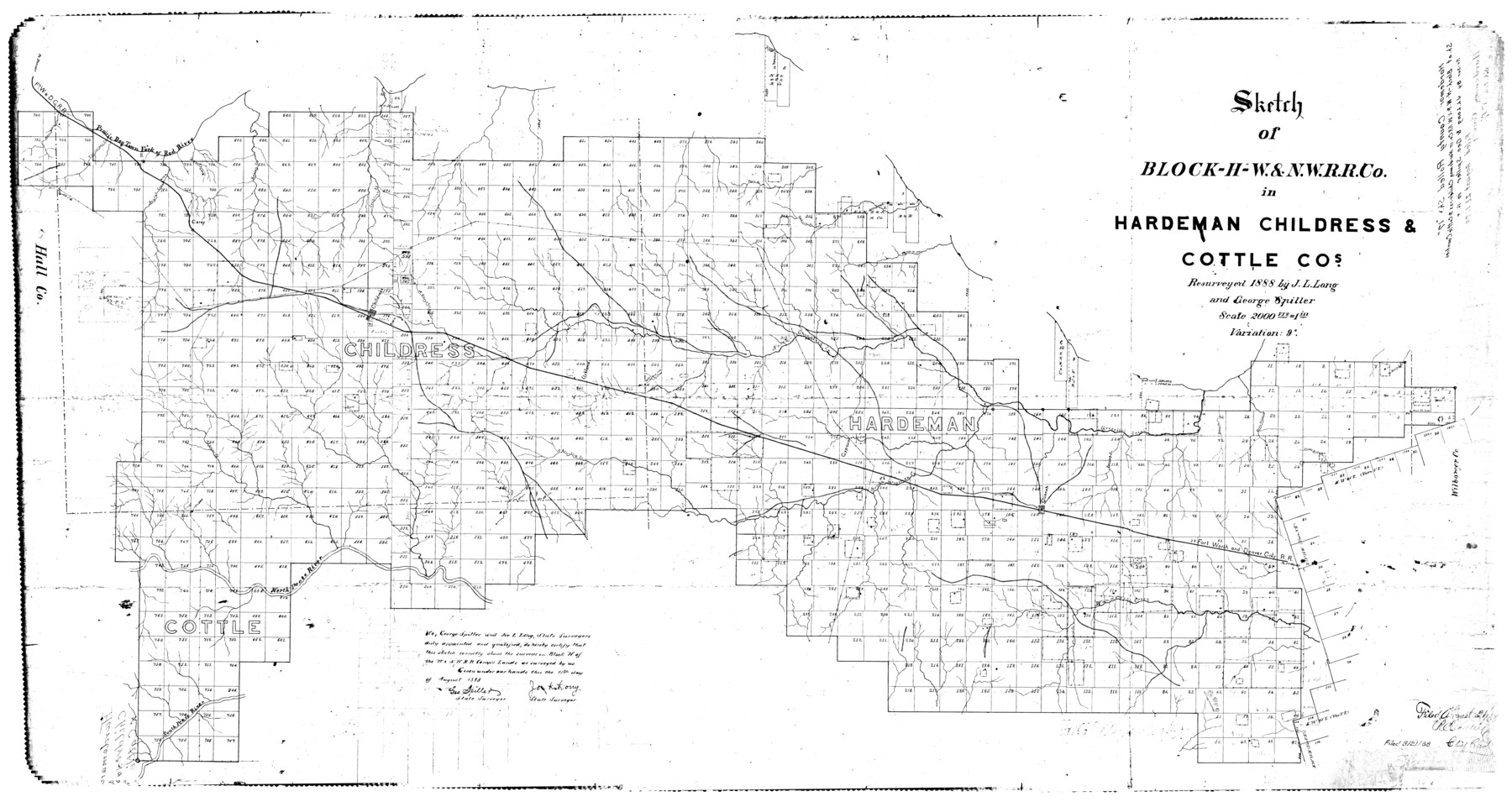
Hardeman County Rolled Sketch 17
Sketch of Block H, W. & N. W. R.R. Co. in Hardeman, Childress & Cottle Cos.
-
Map/Doc
9100
-
Collection
General Map Collection
-
Object Dates
1888 (Creation Date)
1888/8/21 (File Date)
-
People and Organizations
George Spiller (Surveyor/Engineer)
J.L. Long (Surveyor/Engineer)
-
Counties
Hardeman Childress Cottle
-
Subjects
Surveying Rolled Sketch
-
Height x Width
57.9 x 31.1 inches
147.1 x 79.0 cm
-
Scale
1" = 2000 varas
Part of: General Map Collection
Palo Pinto County Rolled Sketch 9

Print $40.00
- Digital $50.00
Palo Pinto County Rolled Sketch 9
Size 78.0 x 30.9 inches
Map/Doc 9675

Brewster County Rolled Sketch 65

Print $40.00
- Digital $50.00
Brewster County Rolled Sketch 65
1940
Size 57.0 x 38.8 inches
Map/Doc 8489
Newton County Working Sketch 1

Print $20.00
- Digital $50.00
Newton County Working Sketch 1
Size 25.5 x 25.9 inches
Map/Doc 71247
Randall County

Print $20.00
- Digital $50.00
Randall County
1917
Size 45.2 x 38.9 inches
Map/Doc 73339
Fort Bend County Rolled Sketch 7

Print $20.00
- Digital $50.00
Fort Bend County Rolled Sketch 7
1919
Size 21.1 x 24.0 inches
Map/Doc 5898
Map of Collingsworth County

Print $20.00
- Digital $50.00
Map of Collingsworth County
1899
Size 41.1 x 38.6 inches
Map/Doc 4738
Flight Mission No. DQN-2K, Frame 99, Calhoun County

Print $20.00
- Digital $50.00
Flight Mission No. DQN-2K, Frame 99, Calhoun County
1953
Size 18.7 x 22.3 inches
Map/Doc 84289
Erath County Working Sketch 39

Print $20.00
- Digital $50.00
Erath County Working Sketch 39
1976
Size 26.9 x 28.0 inches
Map/Doc 69120
Coryell County Working Sketch Graphic Index

Print $20.00
- Digital $50.00
Coryell County Working Sketch Graphic Index
1936
Size 44.8 x 40.5 inches
Map/Doc 76505
Winkler County Sketch File 3

Print $20.00
- Digital $50.00
Winkler County Sketch File 3
Size 38.6 x 33.8 inches
Map/Doc 10436
Lamar County Sketch File 6

Print $40.00
- Digital $50.00
Lamar County Sketch File 6
Size 16.2 x 13.4 inches
Map/Doc 29286
You may also like

San Saba County

Print $20.00
- Digital $50.00
San Saba County
1987
Size 43.5 x 47.3 inches
Map/Doc 95635
Stonewall County Sketch File 24

Print $6.00
- Digital $50.00
Stonewall County Sketch File 24
1951
Size 24.8 x 35.2 inches
Map/Doc 12369
[Sketch showing Miguel Perez, Juan Jose Solis and Francisco Antonio Villareal surveys in Starr County]
![75549, [Sketch showing Miguel Perez, Juan Jose Solis and Francisco Antonio Villareal surveys in Starr County], Maddox Collection](https://historictexasmaps.com/wmedia_w700/maps/75549.tif.jpg)
Print $20.00
- Digital $50.00
[Sketch showing Miguel Perez, Juan Jose Solis and Francisco Antonio Villareal surveys in Starr County]
1914
Size 20.9 x 13.6 inches
Map/Doc 75549
General Highway Map, Kleberg County, Texas

Print $20.00
General Highway Map, Kleberg County, Texas
1961
Size 24.6 x 18.3 inches
Map/Doc 79559
Crane County Working Sketch 26

Print $20.00
- Digital $50.00
Crane County Working Sketch 26
1971
Size 32.4 x 33.0 inches
Map/Doc 68303
Maps & Lists Showing Prison Lands (Oil & Gas) Leased as of June 1955

Digital $50.00
Maps & Lists Showing Prison Lands (Oil & Gas) Leased as of June 1955
1930
Size 24.4 x 26.8 inches
Map/Doc 62876
[Sketch showing San Augustine, Morris, Stephens and Eastland School Land Leagues and adjacent Blocks]
![89918, [Sketch showing San Augustine, Morris, Stephens and Eastland School Land Leagues and adjacent Blocks], Twichell Survey Records](https://historictexasmaps.com/wmedia_w700/maps/89918-1.tif.jpg)
Print $40.00
- Digital $50.00
[Sketch showing San Augustine, Morris, Stephens and Eastland School Land Leagues and adjacent Blocks]
Size 54.7 x 43.5 inches
Map/Doc 89918
Bailey County Rolled Sketch 2

Print $20.00
- Digital $50.00
Bailey County Rolled Sketch 2
1913
Size 26.8 x 21.4 inches
Map/Doc 5109
[Surveys along Big Blue Creek]
![91510, [Surveys along Big Blue Creek], Twichell Survey Records](https://historictexasmaps.com/wmedia_w700/maps/91510-1.tif.jpg)
Print $3.00
- Digital $50.00
[Surveys along Big Blue Creek]
Size 9.5 x 14.8 inches
Map/Doc 91510
Hardeman County Sketch File 30

Print $20.00
- Digital $50.00
Hardeman County Sketch File 30
Size 26.4 x 27.5 inches
Map/Doc 11630
Flight Mission No. DQN-3K, Frame 66, Calhoun County

Print $20.00
- Digital $50.00
Flight Mission No. DQN-3K, Frame 66, Calhoun County
1953
Size 18.7 x 22.5 inches
Map/Doc 84357