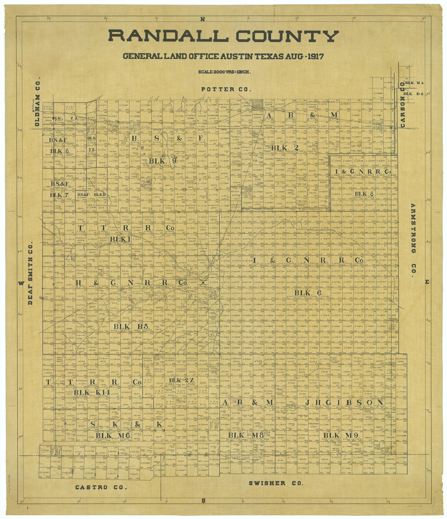
Randall County
-
Map/Doc
73339
-
Collection
General Map Collection
-
Object Dates
1917 (Creation Date)
-
People and Organizations
Texas General Land Office (Publisher)
-
Counties
Randall
-
Subjects
County
-
Height x Width
45.2 x 38.9 inches
114.8 x 98.8 cm
Part of: General Map Collection
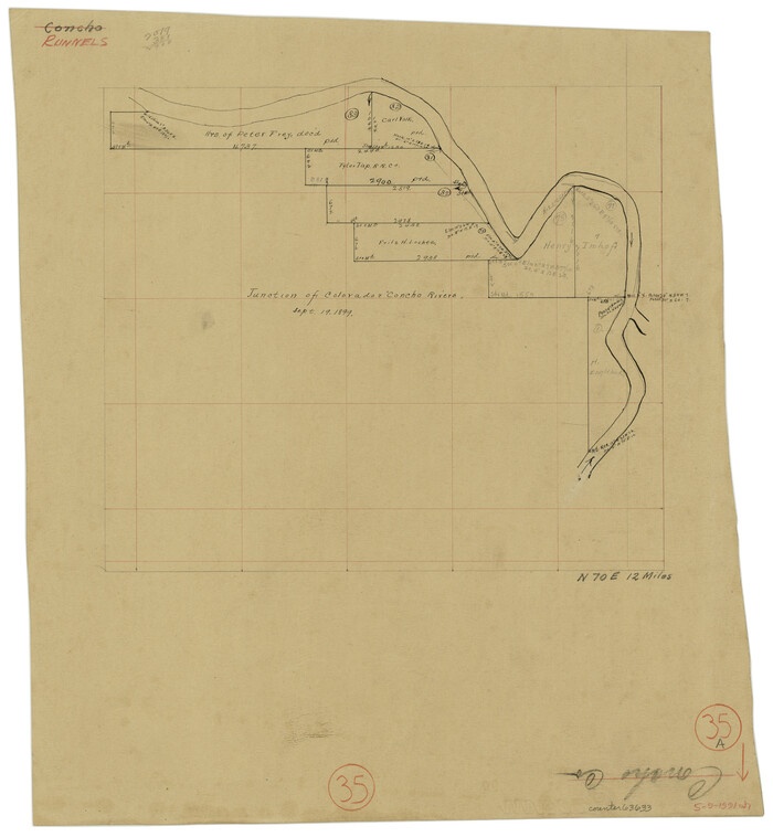
Runnels County Working Sketch 35a
Print $20.00
- Digital $50.00
Runnels County Working Sketch 35a
Size 14.9 x 14.2 inches
Map/Doc 63633
Montgomery County Working Sketch 67

Print $20.00
- Digital $50.00
Montgomery County Working Sketch 67
1972
Size 35.0 x 29.6 inches
Map/Doc 71174
Motley County Sketch File 7 (S)

Print $4.00
- Digital $50.00
Motley County Sketch File 7 (S)
Size 8.1 x 9.6 inches
Map/Doc 32149

Atascosa County Sketch File 20

Print $4.00
- Digital $50.00
Atascosa County Sketch File 20
Size 7.9 x 9.0 inches
Map/Doc 13787
Andrews County

Print $40.00
- Digital $50.00
Andrews County
1925
Size 42.3 x 55.4 inches
Map/Doc 4778
Travis County State Real Property Sketch 12

Print $40.00
- Digital $50.00
Travis County State Real Property Sketch 12
2005
Size 24.0 x 35.6 inches
Map/Doc 88617
Township No. 5 South Range No. 9 West of the Indian Meridian

Print $20.00
- Digital $50.00
Township No. 5 South Range No. 9 West of the Indian Meridian
1874
Size 19.2 x 24.4 inches
Map/Doc 75167
[Pecos River Bed]
![2467, [Pecos River Bed], General Map Collection](https://historictexasmaps.com/wmedia_w700/maps/2467.tif.jpg)
Print $20.00
- Digital $50.00
[Pecos River Bed]
Size 16.6 x 39.8 inches
Map/Doc 2467
Sutton County Sketch File 37

Print $20.00
- Digital $50.00
Sutton County Sketch File 37
Size 19.7 x 19.7 inches
Map/Doc 12387

Val Verde County Working Sketch Graphic Index, Sheet 1 (Sketches 1 to 25)

Print $20.00
- Digital $50.00
Val Verde County Working Sketch Graphic Index, Sheet 1 (Sketches 1 to 25)
1944
Size 40.4 x 36.5 inches
Map/Doc 76724
You may also like
Dallam County

Print $20.00
- Digital $50.00
Dallam County
1888
Size 29.5 x 24.6 inches
Map/Doc 90654
Dawson County Sketch File 26

Print $10.00
- Digital $50.00
Dawson County Sketch File 26
Size 14.7 x 9.1 inches
Map/Doc 20583
Cooke County Boundary File 3

Print $4.00
- Digital $50.00
Cooke County Boundary File 3
Size 7.3 x 8.7 inches
Map/Doc 51853
Comanche County Sketch File 10

Print $4.00
- Digital $50.00
Comanche County Sketch File 10
1859
Size 8.4 x 16.0 inches
Map/Doc 19070
Brazos River Conservation and Reclamation District Official Boundary Line Survey, Parmer County

Print $20.00
- Digital $50.00
Brazos River Conservation and Reclamation District Official Boundary Line Survey, Parmer County
Size 24.6 x 16.8 inches
Map/Doc 91657
[Sketch of Blocks D5-D8]
![93046, [Sketch of Blocks D5-D8], Twichell Survey Records](https://historictexasmaps.com/wmedia_w700/maps/93046-1.tif.jpg)
Print $20.00
- Digital $50.00
[Sketch of Blocks D5-D8]
Size 43.1 x 28.3 inches
Map/Doc 93046
Flight Mission No. BQR-4K, Frame 68, Brazoria County

Print $20.00
- Digital $50.00
Flight Mission No. BQR-4K, Frame 68, Brazoria County
1952
Size 18.7 x 22.4 inches
Map/Doc 84001
Brown County Rolled Sketch 2A

Print $20.00
- Digital $50.00
Brown County Rolled Sketch 2A
1984
Size 25.6 x 37.4 inches
Map/Doc 5350
Gregg County Sketch File 1E

Print $4.00
- Digital $50.00
Gregg County Sketch File 1E
1849
Size 12.6 x 8.2 inches
Map/Doc 24545
[East Half of Hockley County]
![91194, [East Half of Hockley County], Twichell Survey Records](https://historictexasmaps.com/wmedia_w700/maps/91194-1.tif.jpg)
Print $20.00
- Digital $50.00
[East Half of Hockley County]
Size 26.0 x 35.5 inches
Map/Doc 91194
Hardeman County Aerial Photograph Index Sheet 1

Print $20.00
- Digital $50.00
Hardeman County Aerial Photograph Index Sheet 1
1950
Size 19.8 x 17.0 inches
Map/Doc 83697
Ward County Sketch File 9

Print $25.00
- Digital $50.00
Ward County Sketch File 9
1937
Size 10.8 x 8.9 inches
Map/Doc 39623