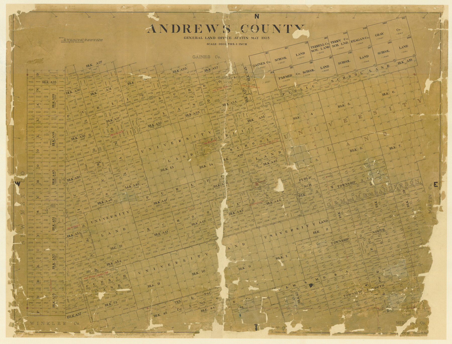
Andrews County
-
Map/Doc
4778
-
Collection
General Map Collection
-
Object Dates
1925 (Creation Date)
-
People and Organizations
Texas General Land Office (Publisher)
Tom G. Atlee (Compiler)
Tom G. Atlee (Draftsman)
-
Counties
Andrews
-
Subjects
County
-
Height x Width
42.3 x 55.4 inches
107.4 x 140.7 cm
-
Comments
Conservation funded in 2006 by Friends of The Texas General Land Office.
-
Features
Florey
Shafter's Lake
Andrews
Fasken
Harvey
Part of: General Map Collection
Kimble County Working Sketch 17

Print $20.00
- Digital $50.00
Kimble County Working Sketch 17
1924
Size 27.8 x 22.5 inches
Map/Doc 70085
Sutton County Working Sketch 56

Print $20.00
- Digital $50.00
Sutton County Working Sketch 56
1958
Size 27.6 x 28.8 inches
Map/Doc 62399
Duval County Working Sketch 27

Print $20.00
- Digital $50.00
Duval County Working Sketch 27
1947
Size 20.7 x 16.8 inches
Map/Doc 68751
Newton County Working Sketch 20

Print $20.00
- Digital $50.00
Newton County Working Sketch 20
1951
Size 22.7 x 15.7 inches
Map/Doc 71266
Navarro County Working Sketch 10

Print $20.00
- Digital $50.00
Navarro County Working Sketch 10
1960
Size 29.7 x 26.0 inches
Map/Doc 71240
Blanco County Rolled Sketch 19

Print $20.00
- Digital $50.00
Blanco County Rolled Sketch 19
Size 20.4 x 17.0 inches
Map/Doc 76409
Flight Mission No. DQN-2K, Frame 157, Calhoun County

Print $20.00
- Digital $50.00
Flight Mission No. DQN-2K, Frame 157, Calhoun County
1953
Size 18.5 x 22.2 inches
Map/Doc 84319
Uvalde County Working Sketch 20

Print $20.00
- Digital $50.00
Uvalde County Working Sketch 20
1950
Size 41.5 x 32.4 inches
Map/Doc 72090
Lynn County Sketch File 4

Print $12.00
- Digital $50.00
Lynn County Sketch File 4
1902
Size 12.8 x 8.2 inches
Map/Doc 30458
Gaines County Sketch File 20

Print $12.00
- Digital $50.00
Gaines County Sketch File 20
1906
Size 7.1 x 8.9 inches
Map/Doc 23335
Chambers County Rolled Sketch 24A

Print $40.00
- Digital $50.00
Chambers County Rolled Sketch 24A
1940
Size 36.5 x 49.0 inches
Map/Doc 8595
Presidio County Rolled Sketch 42

Print $20.00
- Digital $50.00
Presidio County Rolled Sketch 42
1907
Size 31.7 x 19.0 inches
Map/Doc 7339
You may also like
Working Sketch Bastrop County

Print $20.00
- Digital $50.00
Working Sketch Bastrop County
1923
Size 23.1 x 13.7 inches
Map/Doc 90150
El Paso County Boundary File 9

Print $14.00
- Digital $50.00
El Paso County Boundary File 9
Size 12.7 x 8.2 inches
Map/Doc 53111
Polk County Sketch File 23

Print $20.00
- Digital $50.00
Polk County Sketch File 23
Size 18.0 x 18.6 inches
Map/Doc 12191
Bandera County Working Sketch 3

Print $20.00
- Digital $50.00
Bandera County Working Sketch 3
1914
Size 14.5 x 13.9 inches
Map/Doc 67596
Bexar County Sketch File 52

Print $28.00
- Digital $50.00
Bexar County Sketch File 52
1935
Size 13.5 x 16.8 inches
Map/Doc 14534
[Sketch of surveys between Miguel Perez and Francisco Antonio Villareal grants, Starr County]
![5074, [Sketch of surveys between Miguel Perez and Francisco Antonio Villareal grants, Starr County], Maddox Collection](https://historictexasmaps.com/wmedia_w700/maps/5074.tif.jpg)
Print $3.00
- Digital $50.00
[Sketch of surveys between Miguel Perez and Francisco Antonio Villareal grants, Starr County]
1914
Size 16.7 x 10.6 inches
Map/Doc 5074
Counties of Martin, Dawson, Borden, Howard, Texas, Soash Lands, Big Spring Ranch

Print $20.00
- Digital $50.00
Counties of Martin, Dawson, Borden, Howard, Texas, Soash Lands, Big Spring Ranch
Size 34.7 x 36.9 inches
Map/Doc 93006
Bosque County Working Sketch 6

Print $20.00
- Digital $50.00
Bosque County Working Sketch 6
1939
Size 22.3 x 35.6 inches
Map/Doc 67439
[West Part of Labor 18]
![91006, [West Part of Labor 18], Twichell Survey Records](https://historictexasmaps.com/wmedia_w700/maps/91006-1.tif.jpg)
Print $20.00
- Digital $50.00
[West Part of Labor 18]
Size 18.9 x 19.4 inches
Map/Doc 91006
Houston County Sketch File 24a

Print $20.00
- Digital $50.00
Houston County Sketch File 24a
1873
Size 26.3 x 21.0 inches
Map/Doc 11787
General Highway Map, Hansford County, Texas

Print $20.00
General Highway Map, Hansford County, Texas
1940
Size 18.4 x 25.0 inches
Map/Doc 79112
Presidio County Sketch File 79

Print $20.00
- Digital $50.00
Presidio County Sketch File 79
1949
Size 17.0 x 30.8 inches
Map/Doc 11722