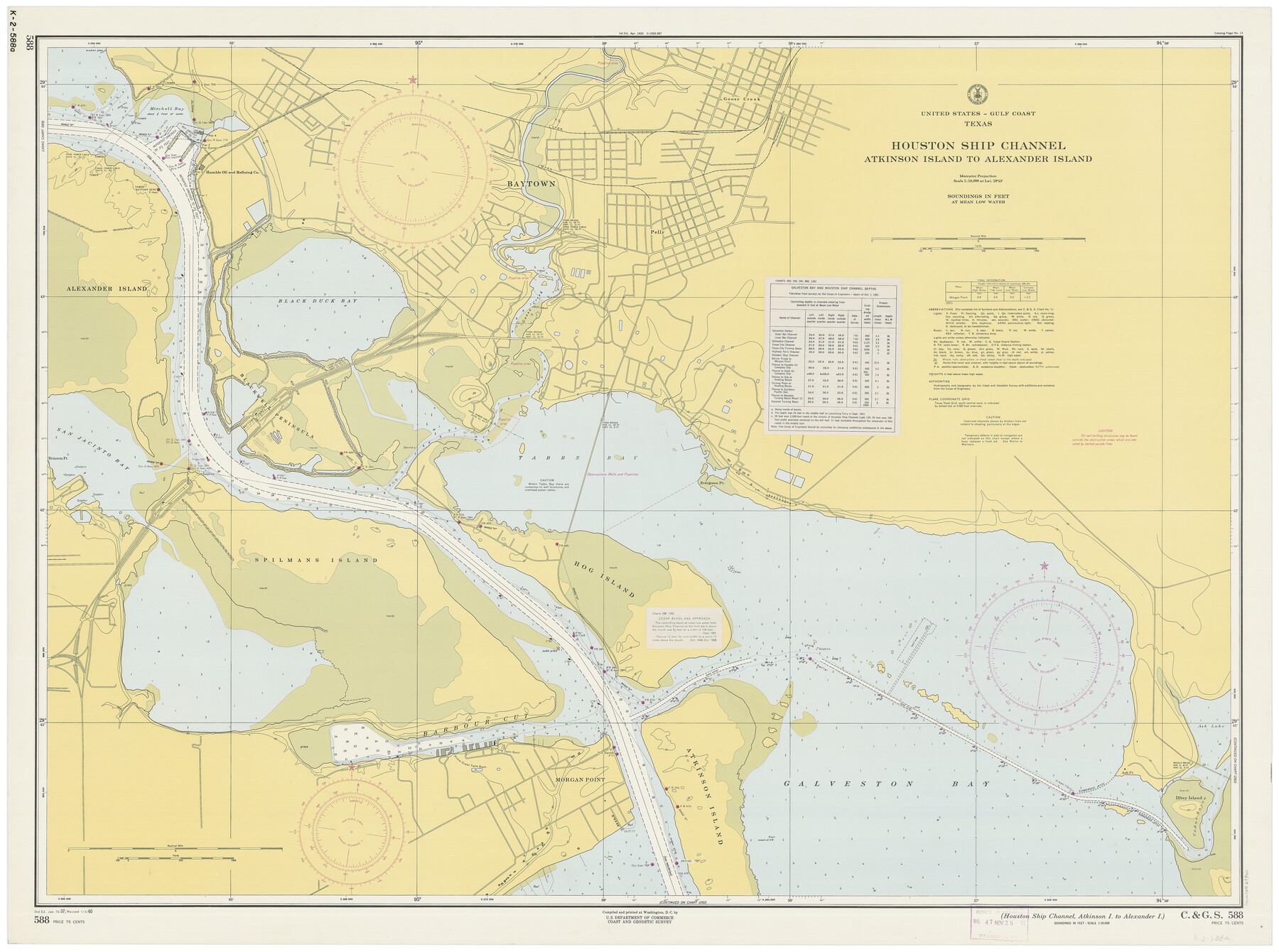
Houston Ship Channel, Atkinson Island to Alexander Island
K-2-588a
-
Map/Doc
69900
-
Collection
General Map Collection
-
Object Dates
1/4/1960 (Creation Date)
-
Counties
Harris Chambers
-
Subjects
Nautical Charts
-
Height x Width
33.2 x 44.0 inches
84.3 x 111.8 cm
Part of: General Map Collection
Padre Island National Seashore, Texas - Dependent Resurvey

Print $4.00
- Digital $50.00
Padre Island National Seashore, Texas - Dependent Resurvey
2001
Size 18.2 x 24.3 inches
Map/Doc 60552
Freestone County Working Sketch 4

Print $20.00
- Digital $50.00
Freestone County Working Sketch 4
1921
Size 29.6 x 22.7 inches
Map/Doc 69246
Andrews County Rolled Sketch 17

Print $40.00
- Digital $50.00
Andrews County Rolled Sketch 17
1934
Size 30.9 x 48.9 inches
Map/Doc 8393
Flight Mission No. CGI-3N, Frame 174, Cameron County

Print $20.00
- Digital $50.00
Flight Mission No. CGI-3N, Frame 174, Cameron County
1954
Size 18.5 x 22.1 inches
Map/Doc 84638
Flight Mission No. BRA-6M, Frame 83, Jefferson County

Print $20.00
- Digital $50.00
Flight Mission No. BRA-6M, Frame 83, Jefferson County
1953
Size 18.6 x 22.3 inches
Map/Doc 85427
Mills County Working Sketch 14

Print $20.00
- Digital $50.00
Mills County Working Sketch 14
1946
Size 27.5 x 28.1 inches
Map/Doc 71044
Fisher County Working Sketch 6

Print $20.00
- Digital $50.00
Fisher County Working Sketch 6
1929
Size 38.7 x 33.6 inches
Map/Doc 69140

Map of Caldwell County

Print $20.00
- Digital $50.00
Map of Caldwell County
1871
Size 16.9 x 19.9 inches
Map/Doc 4591
Edwards County Working Sketch 71

Print $20.00
- Digital $50.00
Edwards County Working Sketch 71
1957
Size 17.4 x 23.8 inches
Map/Doc 68947
Flight Mission No. DQN-3K, Frame 36, Calhoun County

Print $20.00
- Digital $50.00
Flight Mission No. DQN-3K, Frame 36, Calhoun County
1953
Size 18.6 x 22.2 inches
Map/Doc 84349
Midland County Working Sketch 5

Print $20.00
- Digital $50.00
Midland County Working Sketch 5
1893
Size 31.2 x 25.6 inches
Map/Doc 70985
You may also like
Real County Working Sketch 24

Print $20.00
- Digital $50.00
Real County Working Sketch 24
1946
Size 17.4 x 22.5 inches
Map/Doc 71916
Survey of Mustang Is., Joseph's and a part of Matagorda Island.

Print $20.00
- Digital $50.00
Survey of Mustang Is., Joseph's and a part of Matagorda Island.
1834
Size 19.5 x 20.2 inches
Map/Doc 3183
Map of Waller County

Print $20.00
- Digital $50.00
Map of Waller County
1897
Size 46.7 x 28.9 inches
Map/Doc 16915
[Worksheets related to the Wilson Strickland survey and vicinity]
![91381, [Worksheets related to the Wilson Strickland survey and vicinity], Twichell Survey Records](https://historictexasmaps.com/wmedia_w700/maps/91381-1.tif.jpg)
Print $20.00
- Digital $50.00
[Worksheets related to the Wilson Strickland survey and vicinity]
Size 20.1 x 24.8 inches
Map/Doc 91381
Coke County Rolled Sketch 16

Print $20.00
- Digital $50.00
Coke County Rolled Sketch 16
1950
Size 44.0 x 34.3 inches
Map/Doc 8630
[Sketch of part of G. & M. Block 5, G. & M. Block 4, Block M19 and Block 21W]
![93085, [Sketch of part of G. & M. Block 5, G. & M. Block 4, Block M19 and Block 21W], Twichell Survey Records](https://historictexasmaps.com/wmedia_w700/maps/93085-1.tif.jpg)
Print $20.00
- Digital $50.00
[Sketch of part of G. & M. Block 5, G. & M. Block 4, Block M19 and Block 21W]
Size 23.1 x 17.8 inches
Map/Doc 93085
Harris County Boundary File 39 (19)

Print $4.00
- Digital $50.00
Harris County Boundary File 39 (19)
Size 12.6 x 7.9 inches
Map/Doc 54361
Brown County Working Sketch 5

Print $20.00
- Digital $50.00
Brown County Working Sketch 5
1939
Size 20.9 x 24.0 inches
Map/Doc 67770
Flight Mission No. BRE-1P, Frame 143, Nueces County

Print $20.00
- Digital $50.00
Flight Mission No. BRE-1P, Frame 143, Nueces County
1956
Size 18.3 x 22.2 inches
Map/Doc 86703
Fisher County Boundary File 1

Print $16.00
- Digital $50.00
Fisher County Boundary File 1
Size 12.8 x 8.4 inches
Map/Doc 53411
Nueces County Working Sketch 1

Print $20.00
- Digital $50.00
Nueces County Working Sketch 1
1937
Size 27.9 x 28.5 inches
Map/Doc 71303
Lynn County Sketch File 21

Print $52.00
- Digital $50.00
Lynn County Sketch File 21
1913
Size 5.7 x 8.6 inches
Map/Doc 30528